world.wikisort.org - USA
Lucerne is a ghost town in Adell Township, Sheridan County, Kansas, United States. It is approximately 18 miles northeast of the county seat of Hoxie.
Lucerne, Kansas | |
|---|---|
Ghost town | |
 KDOT map of Sheridan County (legend) | |
 Lucerne  Lucerne | |
| Coordinates: 39°29′48″N 100°12′01″W | |
| Country | United States |
| State | Kansas |
| County | Sheridan |
| Township | Adell |
| Elevation | 2,648 ft (807 m) |
| Population | |
| • Total | 0 |
| Time zone | UTC-6 (CST) |
| • Summer (DST) | UTC-5 (CDT) |
| Area code | 785 |
| GNIS ID | 484550[1] |
History
The town had a post office from 1880 until 1943. As of 2010, the remains of the town included a cemetery, stone foundation, and a partial wooden sign that used to announce the town's name.[2] As of the 2010 census, the entirety of Adell Township had a population of only 12.[3]
According to a 1912 reference work on Kansas, the town at that time held a population of 50, a general store, a hotel, a money order post office, and a daily stagecoach to the town of Jennings.[4]
References
- "Lucerne". Geographic Names Information System. United States Geological Survey.
- Bickel, Amy (October 2010). Chicago mirrored what killed towns, The Hutchinson News
- Adell Township, 2010 census information Archived 2020-02-14 at archive.today, American Fact Finder, retrieved 23 October 2017
- Kansas: A Cyclopedia of State History, p. 193 (1912)
Further reading
External links
- Lucerne Cemetery interments, KSGenweb.com
- Lucerne photos, Kansas Historical Society
- Sheridan County maps: Current, Historic, KDOT
Municipalities and communities of Sheridan County, Kansas, United States | ||
|---|---|---|
County seat: Hoxie | ||
| Cities | 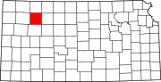 | |
| Unincorporated communities |
| |
| Ghost towns | ||
| Townships |
| |
| ||
Текст в блоке "Читать" взят с сайта "Википедия" и доступен по лицензии Creative Commons Attribution-ShareAlike; в отдельных случаях могут действовать дополнительные условия.
Другой контент может иметь иную лицензию. Перед использованием материалов сайта WikiSort.org внимательно изучите правила лицензирования конкретных элементов наполнения сайта.
Другой контент может иметь иную лицензию. Перед использованием материалов сайта WikiSort.org внимательно изучите правила лицензирования конкретных элементов наполнения сайта.
2019-2026
WikiSort.org - проект по пересортировке и дополнению контента Википедии
WikiSort.org - проект по пересортировке и дополнению контента Википедии