world.wikisort.org - USA
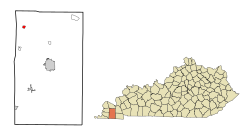
Lowes is an unincorporated community and census-designated place (CDP) in Graves County, Kentucky, United States.[3] Lowes is 13 miles (21 km) northwest of Mayfield. As of the 2010 Census the population of Lowes was 98.[4]
Lowes, Kentucky | |
|---|---|
Census-designated place | |
 | |
| Coordinates: 36°53′08″N 88°46′26″W | |
| Country | United States |
| State | Kentucky |
| County | Graves |
| Area | |
| • Total | 0.69 sq mi (1.78 km2) |
| • Land | 0.69 sq mi (1.77 km2) |
| • Water | 0.00 sq mi (0.00 km2) |
| Elevation | 469 ft (143 m) |
| Population (2020) | |
| • Total | 92 |
| • Density | 134.31/sq mi (51.84/km2) |
| Time zone | UTC-6 (Central (CST)) |
| • Summer (DST) | UTC-5 (CDT) |
| Area code(s) | 270 & 364 |
| GNIS feature ID | 497318[2] |
Demographics
| Historical population | |||
|---|---|---|---|
| Census | Pop. | %± | |
| 2020 | 92 | — | |
| U.S. Decennial Census[5] | |||
Notable people
- Alben W. Barkley, U.S. Senator and Vice President of the United States, born near Lowes
- J. Paul Hogan, pioneer in the invention of the plastics industry, born in Lowes
References
- "2020 U.S. Gazetteer Files". United States Census Bureau. Retrieved March 18, 2022.
- "US Board on Geographic Names". United States Geological Survey. 2007-10-25. Retrieved 2008-01-31.
- "Feature Detail Report for: Lowes, Kentucky." United States Geological Survey. U.S. Geological Survey Geographic Names Information System: Lowes, Kentucky Retrieved May 11, 2011.
- "Geographic Identifiers: 2010 Demographic Profile Data (G001): Lowes CDP, Kentucky". American Factfinder. U.S. Census Bureau. Retrieved December 12, 2016.[dead link]
- "Census of Population and Housing". Census.gov. Retrieved June 4, 2016.
Municipalities and communities of Graves County, Kentucky, United States | ||
|---|---|---|
County seat: Mayfield | ||
| Cities | 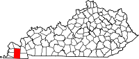 | |
| CDPs | ||
| Unincorporated communities |
| |
| Footnotes | ‡This populated place also has portions in an adjacent county or counties | |
| ||
This Graves County, Kentucky state location article is a stub. You can help Wikipedia by expanding it. |
На других языках
- [en] Lowes, Kentucky
[ru] Лоус (Кентукки)
Лоус (англ. Lowes) — статистически обособленная местность, расположенная в округе Грейвс штата Кентукки, США.Текст в блоке "Читать" взят с сайта "Википедия" и доступен по лицензии Creative Commons Attribution-ShareAlike; в отдельных случаях могут действовать дополнительные условия.
Другой контент может иметь иную лицензию. Перед использованием материалов сайта WikiSort.org внимательно изучите правила лицензирования конкретных элементов наполнения сайта.
Другой контент может иметь иную лицензию. Перед использованием материалов сайта WikiSort.org внимательно изучите правила лицензирования конкретных элементов наполнения сайта.
2019-2026
WikiSort.org - проект по пересортировке и дополнению контента Википедии
WikiSort.org - проект по пересортировке и дополнению контента Википедии