world.wikisort.org - USA
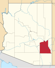
Lone Star is a populated place situated in Graham County, Arizona, United States.[2] It has an estimated elevation of 2,953 feet (900 m) above sea level.[1] Eight miles north of Solomonville, the community was named after the nearby mine and mountain.[3]
Lone Star, Arizona | |
|---|---|
Populated place | |
 Lone Star Location within the state of Arizona  Lone Star Lone Star (the United States) | |
| Coordinates: 32°48′59″N 109°40′52″W | |
| Country | United States |
| State | Arizona |
| County | Graham |
| Elevation | 2,953 ft (900 m) |
| Time zone | UTC-7 (Mountain (MST)) |
| • Summer (DST) | UTC-7 (MST) |
| Area code(s) | 928 |
| FIPS code | 04-41820 |
| GNIS feature ID | 7310 |
References
- "Feature Detail Report for: Lone Star". Geographic Names Information System. United States Geological Survey, United States Department of the Interior.
- "Lone Star (in Graham County, AZ) Populated Place Profile". AZ Hometown Locator. Retrieved November 27, 2016.
- Barnes, Will Croft (2016). Arizona Place Names. Tucson: University of Arizona Press. p. 252. ISBN 978-0816534951.
Текст в блоке "Читать" взят с сайта "Википедия" и доступен по лицензии Creative Commons Attribution-ShareAlike; в отдельных случаях могут действовать дополнительные условия.
Другой контент может иметь иную лицензию. Перед использованием материалов сайта WikiSort.org внимательно изучите правила лицензирования конкретных элементов наполнения сайта.
Другой контент может иметь иную лицензию. Перед использованием материалов сайта WikiSort.org внимательно изучите правила лицензирования конкретных элементов наполнения сайта.
2019-2025
WikiSort.org - проект по пересортировке и дополнению контента Википедии
WikiSort.org - проект по пересортировке и дополнению контента Википедии
