world.wikisort.org - USA
Linton Township is one of twelve townships in Vigo County, Indiana, United States. As of the 2010 census, its population was 1,323 and it contained 555 housing units.[1]
Linton Township | |
|---|---|
Township | |
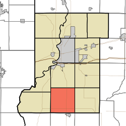 Location in Vigo County | |
| Coordinates: 39°18′23″N 87°24′43″W | |
| Country | United States |
| State | Indiana |
| County | Vigo |
| Government | |
| • Type | Indiana township |
| Area | |
| • Total | 35.43 sq mi (91.8 km2) |
| • Land | 34.97 sq mi (90.6 km2) |
| • Water | 0.46 sq mi (1.2 km2) 1.30% |
| Elevation | 574 ft (175 m) |
| Population (2010) | |
| • Total | 1,323 |
| • Density | 37.8/sq mi (14.6/km2) |
| ZIP codes | 47802, 47850, 47866 |
| GNIS feature ID | 453575 |
History
Linton Township High School and Community Building was listed on the National Register of Historic Places in 2002.[2]
Geography
According to the 2010 census, the township has a total area of 35.43 square miles (91.8 km2), of which 34.97 square miles (90.6 km2) (or 98.70%) is land and 0.46 square miles (1.2 km2) (or 1.30%) is water.[1]
Unincorporated communities
- Pimento
Adjacent townships
- Honey Creek Township (north)
- Riley Township (northeast)
- Pierson Township (east)
- Jackson Township, Sullivan County (southeast)
- Curry Township, Sullivan County (south)
- Fairbanks Township, Sullivan County (southwest)
- Prairie Creek Township (west)
- Prairieton Township (northwest)
Cemeteries
The township contains three cemeteries: Kester Family Cemetery, Brown, and Union.
Airports and landing strips
- Kester Fly Inn Airport
Lakes
- Fowler Lake
School districts
- Vigo County School Corporation
Political districts
- Indiana's 8th congressional district
- State House District 46
- State Senate District 39
References
- United States Census Bureau 2007 TIGER/Line Shapefiles
- United States Board on Geographic Names (GNIS)
- IndianaMap
- "Population, Housing Units, Area, and Density: 2010 - County -- County Subdivision and Place -- 2010 Census Summary File 1". United States Census. Archived from the original on 2020-02-10. Retrieved 2013-05-10.
- "National Register Information System". National Register of Historic Places. National Park Service. July 9, 2010.
External links
Municipalities and communities of Vigo County, Indiana, United States | ||
|---|---|---|
County seat: Terre Haute | ||
| City |
|  |
| Towns |
| |
| Townships |
| |
| CDPs |
| |
| Other unincorporated communities |
| |
| Footnotes | ‡This populated place also has portions in an adjacent county or counties | |
| ||
Текст в блоке "Читать" взят с сайта "Википедия" и доступен по лицензии Creative Commons Attribution-ShareAlike; в отдельных случаях могут действовать дополнительные условия.
Другой контент может иметь иную лицензию. Перед использованием материалов сайта WikiSort.org внимательно изучите правила лицензирования конкретных элементов наполнения сайта.
Другой контент может иметь иную лицензию. Перед использованием материалов сайта WikiSort.org внимательно изучите правила лицензирования конкретных элементов наполнения сайта.
2019-2025
WikiSort.org - проект по пересортировке и дополнению контента Википедии
WikiSort.org - проект по пересортировке и дополнению контента Википедии