world.wikisort.org - USA
LeLoup is an unincorporated community in Franklin County, Kansas, United States.[1] It is located a mile and half north of Interstate 35 on Tennessee Road, 11 miles northeast of Ottawa, 7 miles southwest of Wellsville.
LeLoup, Kansas | |
|---|---|
Unincorporated community | |
 KDOT map of Franklin County (legend) | |
 LeLoup  LeLoup | |
| Coordinates: 38°24′52″N 95°5′37″W[1] | |
| Country | United States |
| State | Kansas |
| County | Franklin |
| Founded | 1870 |
| Named for | Wolf |
| Elevation | 955 ft (291 m) |
| Time zone | UTC-6 (CST) |
| • Summer (DST) | UTC-5 (CDT) |
| Area code | 785 |
| FIPS code | 20-39300 [1] |
| GNIS ID | 479371 [1] |
History
LeLoup was founded in 1870 after the Santa Fe Railroad laid tracks through the area. The community was originally named Ferguson after Robert Ferguson, the original owner of the town site.[2] The community was renamed LeLoup after a French traveler got off at Ferguson and mistook a coyote for a wolf and began shouting "le loup", then the community voted to change the name to LeLoup.
LeLoup had a post office from September 1870 until 1954; the name of the post office was changed from Ferguson in 1879.[3]
Gallery
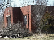 An old school in LeLoup (2008)

References
- "LeLoup, Kansas", Geographic Names Information System, United States Geological Survey
- Blackmar, Frank Wilson (1912). Kansas: A Cyclopedia of State History, Volume 2. Standard Publishing Company. pp. 137.
- "Kansas Post Offices, 1828-1961 (archived)". Kansas Historical Society. Archived from the original on 9 October 2013. Retrieved 10 June 2014.
Further reading
- Fitzgerald, Daniel. Ghost Towns of Kansas 6. 2009.
External links
Municipalities and communities of Franklin County, Kansas, United States | ||
|---|---|---|
County seat: Ottawa | ||
| Cities |  | |
| Unincorporated communities |
| |
| Ghost towns |
| |
| Townships |
| |
| Footnotes | †This community is designated a Census-Designated Place (CDP) by the United States Census Bureau. | |
| ||
Текст в блоке "Читать" взят с сайта "Википедия" и доступен по лицензии Creative Commons Attribution-ShareAlike; в отдельных случаях могут действовать дополнительные условия.
Другой контент может иметь иную лицензию. Перед использованием материалов сайта WikiSort.org внимательно изучите правила лицензирования конкретных элементов наполнения сайта.
Другой контент может иметь иную лицензию. Перед использованием материалов сайта WikiSort.org внимательно изучите правила лицензирования конкретных элементов наполнения сайта.
2019-2026
WikiSort.org - проект по пересортировке и дополнению контента Википедии
WikiSort.org - проект по пересортировке и дополнению контента Википедии