world.wikisort.org - USA
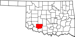
The Lawton Metropolitan Statistical Area, as defined by the United States Census Bureau, is an area consisting of two counties – Comanche and Cotton – in Oklahoma, anchored by the city of Lawton. As of the 2010 census, the MSA had a population of 130,291.[1][2]
Lawton metropolitan area | |
|---|---|
Metropolitan statistical area | |
| Lawton Metropolitan Statistical Area | |
 | |
| Coordinates: 34°39′45″N 98°28′35″W | |
| Country | United States |
| State(s) | Oklahoma |
| Largest city | Lawton, Oklahoma |
| Other cities | - Cache - Elgin |
| Area | |
| • Total | 1,069.3 sq mi (2,769 km2) |
| Highest elevation | 2,476 ft (754 m) |
| Lowest elevation | 1,000 ft (304 m) |
| Population | |
| • Total | 130,291 (2,010 Census) |
| • Rank | 324th in the U.S. |
| • Density | 116.1/sq mi (44.8/km2) |
Counties
Communities
Cities
- Cache
- Elgin
- Lawton (Principal city)
- Walters (County Seat)
Towns
- Ahpeatone
- Chattanooga (partial)
- Cookietown
- Devol
- Emerson Center
- Faxon
- Fivemile
- Fletcher
- Geronimo
- Hooper
- Hulen
- Indiahoma
- Medicine Park
- Randlett
- Sterling
- Taylor
- Temple
See also
- Oklahoma census statistical areas
References
- "Table 1. Annual Estimates of the Population of Metropolitan and Micropolitan Statistical Areas: April 1, 2010 to July 1, 2012". 2012 Population Estimates. United States Census Bureau, Population Division. March 2013. Archived from the original (CSV) on April 1, 2013. Retrieved March 17, 2013.
- http://www2.census.gov/geo/maps/metroarea/stcbsa_pg/Feb2013/cbsa2013_OK.pdf [bare URL PDF]
Oklahoma City (capital) | ||
| Topics |
|  |
| Society |
| |
| Regions |
| |
| Largest cities |
| |
| Counties |
| |
Текст в блоке "Читать" взят с сайта "Википедия" и доступен по лицензии Creative Commons Attribution-ShareAlike; в отдельных случаях могут действовать дополнительные условия.
Другой контент может иметь иную лицензию. Перед использованием материалов сайта WikiSort.org внимательно изучите правила лицензирования конкретных элементов наполнения сайта.
Другой контент может иметь иную лицензию. Перед использованием материалов сайта WikiSort.org внимательно изучите правила лицензирования конкретных элементов наполнения сайта.
2019-2025
WikiSort.org - проект по пересортировке и дополнению контента Википедии
WikiSort.org - проект по пересортировке и дополнению контента Википедии