world.wikisort.org - USA
Lawndale is an unincorporated community in Prairie View Township, Wilkin County, Minnesota, United States.[1]
Lawndale | |
|---|---|
Unincorporated community | |
 Lawndale  Lawndale | |
| Coordinates: 46°33′25″N 96°21′37″W | |
| Country | United States |
| State | Minnesota |
| County | Wilkin |
| Elevation | 1,070 ft (330 m) |
| Time zone | UTC-6 (Central (CST)) |
| • Summer (DST) | UTC-5 (CDT) |
| Area code(s) | 218 |
| GNIS feature ID | 646532[1] |
The community is located between Rothsay and Barnesville at the junction of County Road 30 and County Road 52.
Lawndale is immediately west of the junction of Interstate 94 and State Highway 108 / County 30.
References
- "Lawndale". Geographic Names Information System. United States Geological Survey, United States Department of the Interior.
Rand McNally Road Atlas - 2007 edition - Minnesota entry
Official State of Minnesota Highway Map - 2007/2008 edition
Municipalities and communities of Wilkin County, Minnesota, United States | ||
|---|---|---|
County seat: Breckenridge | ||
| Cities | 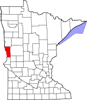 | |
| Townships | ||
| Unincorporated communities |
| |
| Footnotes | ‡This populated place also has portions in an adjacent county or counties | |
| ||
Текст в блоке "Читать" взят с сайта "Википедия" и доступен по лицензии Creative Commons Attribution-ShareAlike; в отдельных случаях могут действовать дополнительные условия.
Другой контент может иметь иную лицензию. Перед использованием материалов сайта WikiSort.org внимательно изучите правила лицензирования конкретных элементов наполнения сайта.
Другой контент может иметь иную лицензию. Перед использованием материалов сайта WikiSort.org внимательно изучите правила лицензирования конкретных элементов наполнения сайта.
2019-2026
WikiSort.org - проект по пересортировке и дополнению контента Википедии
WikiSort.org - проект по пересортировке и дополнению контента Википедии