world.wikisort.org - USA
Lashmeet is a census-designated place (CDP) in western Mercer County, West Virginia, United States. It lies along West Virginia Route 10 northwest of the city of Princeton, the county seat of Mercer County.[3] Its elevation is 2,539 feet (774 m).[4] Although Lashmeet is unincorporated, it has a post office, with the ZIP code of 24733.[5] As of the 2010 census, its population was 479.[2]
Lashmeet | |
|---|---|
Census-designated place (CDP) | |
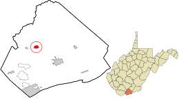 Location in Mercer County and the state of West Virginia. | |
| Coordinates: 37°25′15″N 81°11′57″W | |
| Country | United States |
| State | West Virginia |
| County | Mercer |
| Area | |
| • Total | 0.750 sq mi (1.94 km2) |
| • Land | 0.750 sq mi (1.94 km2) |
| • Water | 0 sq mi (0 km2) |
| Population (2010)[2] | |
| • Total | 479 |
| • Density | 640/sq mi (250/km2) |
| Time zone | UTC-5 (Eastern (EST)) |
| • Summer (DST) | UTC-4 (EDT) |
| ZIP codes | 24733 |
The community most likely derives its name from the local Lashmeet (or Lashmutt) family.[6]
References
- "US Gazetteer files: 2010, 2000, and 1990". United States Census Bureau. 2011-02-12. Retrieved 2011-04-23.
- "U.S. Census website". United States Census Bureau. Retrieved 2011-05-14.
- DeLorme. West Virginia Atlas & Gazetteer. 4th ed. Yarmouth: DeLorme, 2007, p. 59. ISBN 0-89933-327-3.
- U.S. Geological Survey Geographic Names Information System: Lashmeet, West Virginia, Geographic Names Information System, 1980-06-27. Accessed 2008-06-02.
- Zip Code Lookup
- Kenny, Hamill (1945). West Virginia Place Names: Their Origin and Meaning, Including the Nomenclature of the Streams and Mountains. Piedmont, WV: The Place Name Press. p. 360.
Municipalities and communities of Mercer County, West Virginia, United States | ||
|---|---|---|
County seat: Princeton | ||
| Cities |
|  |
| Towns |
| |
| CDPs | ||
| Other communities |
| |
| Ghost town | ||
| Footnotes | ‡This populated place also has portions in an adjacent county or counties | |
| ||
This article about a location in Mercer County, West Virginia is a stub. You can help Wikipedia by expanding it. |
Текст в блоке "Читать" взят с сайта "Википедия" и доступен по лицензии Creative Commons Attribution-ShareAlike; в отдельных случаях могут действовать дополнительные условия.
Другой контент может иметь иную лицензию. Перед использованием материалов сайта WikiSort.org внимательно изучите правила лицензирования конкретных элементов наполнения сайта.
Другой контент может иметь иную лицензию. Перед использованием материалов сайта WikiSort.org внимательно изучите правила лицензирования конкретных элементов наполнения сайта.
2019-2025
WikiSort.org - проект по пересортировке и дополнению контента Википедии
WikiSort.org - проект по пересортировке и дополнению контента Википедии