world.wikisort.org - USA
Kingston is an unincorporated community in Des Moines County, Iowa, United States. It is part of the Burlington, IA–IL Micropolitan Statistical Area. Kingston is located along State Highway 99, approximately 15 miles north of Burlington.[2]
Kingston, Iowa | |
|---|---|
Unincorporated community | |
 Streetside in Kingston | |
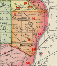
 Kingston Location within the state of Iowa | |
| Coordinates: 40°58′36″N 91°2′26″W | |
| Country | United States |
| State | Iowa |
| County | Des Moines |
| Area | |
| • Total | 1.77 sq mi (4.59 km2) |
| • Land | 1.77 sq mi (4.59 km2) |
| • Water | 0.00 sq mi (0.00 km2) |
| Population (2020) | |
| • Total | 81 |
| • Density | 45.71/sq mi (17.65/km2) |
| Time zone | UTC-6 (Central (CST)) |
| • Summer (DST) | UTC-5 (CDT) |
| ZIP codes | 52637 |
| Area code(s) | 319 |
| FIPS code | 19-41430 |
Demographics
| Historical population | |||
|---|---|---|---|
| Census | Pop. | %± | |
| 2020 | 81 | — | |
| U.S. Decennial Census[3] | |||
History
Kingston is known for its Late Prehistoric Kingston Oneota Site[4] and it is close to the Malchow Mounds State Preserve and the grave of Taimah, a native chieftain.
Kingston was named for its founder, W. King.[5]
References
- "2020 U.S. Gazetteer Files". United States Census Bureau. Retrieved March 16, 2022.
- Iowa Department of Transportation (2008): Iowa Transportation Map. Ames: Iowa Department of Transportation.
- "Census of Population and Housing". Census.gov. Retrieved June 4, 2016.
- Straffin,Dean (1971):The Kingston Oneota Site. Iowa City: University of Iowa.
- The History of Des Moines County, Iowa: Containing a History of the County, Its Cities, Towns, &c. Western Historical Company. 1879. pp. 615.
Municipalities and communities of Des Moines County, Iowa, United States | ||
|---|---|---|
County seat: Burlington | ||
| Cities |
|  |
| Townships |
| |
| CDPs | ||
| Other community |
| |
| ||
This article about the geography of Des Moines County, Iowa is a stub. You can help Wikipedia by expanding it. |
Текст в блоке "Читать" взят с сайта "Википедия" и доступен по лицензии Creative Commons Attribution-ShareAlike; в отдельных случаях могут действовать дополнительные условия.
Другой контент может иметь иную лицензию. Перед использованием материалов сайта WikiSort.org внимательно изучите правила лицензирования конкретных элементов наполнения сайта.
Другой контент может иметь иную лицензию. Перед использованием материалов сайта WikiSort.org внимательно изучите правила лицензирования конкретных элементов наполнения сайта.
2019-2026
WikiSort.org - проект по пересортировке и дополнению контента Википедии
WikiSort.org - проект по пересортировке и дополнению контента Википедии