world.wikisort.org - USA
Keytesville is a city in and the county seat of Chariton County, Missouri, United States.[4] The population was 440 as of the 2020 census.[5] Keytesville is the hometown of U.S. Army General Maxwell D. Taylor, who commanded the "Screaming Eagles" 101st Airborne division during the Normandy invasion of World War II. Confederate General Sterling Price, who attacked Keytesville during an unsuccessful cavalry raid across his home state, had previously operated a hotel there.
Keytesville, Missouri | |
|---|---|
City | |
| City of Keytesville | |
 Location of Keytesville, Missouri | |
| Coordinates: 39°26′3″N 92°56′13″W | |
| Country | United States |
| State | Missouri |
| County | Chariton |
| Incorporated | 1868 |
| Named for | James Keyte |
| Area | |
| • Total | 0.78 sq mi (2.02 km2) |
| • Land | 0.77 sq mi (1.99 km2) |
| • Water | 0.01 sq mi (0.03 km2) |
| Elevation | 715 ft (218 m) |
| Population (2020) | |
| • Total | 440 |
| • Density | 572.17/sq mi (220.93/km2) |
| Time zone | UTC-6 (Central (CST)) |
| • Summer (DST) | UTC-5 (CDT) |
| ZIP code | 65261 |
| Area code(s) | 660 |
| FIPS code | 29-38468[3] |
| GNIS feature ID | 0720566[2] |
History

The town is named for Englishman James Keyte, the town founder.[6] Keyte, a Methodist preacher, purchased a large parcel of land in 1830 and, two years later, donated fifty acres of it to Chariton County for the purpose of establishing a centralized seat of county government.[7] Prior to that time, the county business had been conducted from "Old Chariton," a small village near the confluence of the Chariton and Missouri Rivers. However, incessant disease-spreading mosquitoes and repeated river flooding necessitated a new location.[8]
The first courthouse was constructed in Keytesville between 1833 and 1834. As a two-story, four-room brick building, it survived until September 20, 1864, when it was burned down by the Confederate raiders during the American Civil War.[8] James Keyte constructed the first home in Keytesville, and the first business as well. Both were log structures, with the second doubling as a post office. Keyte is also responsible for the town's first industry of any sort, when he constructed a mill near his home on Mussel Fork Creek.[7] Isaac Redding added Keytesville's first hotel in August 1842. Keytesville was incorporated on February 3, 1868, by the state of Missouri, and incorporated as a Missouri 4th class city in March 1883.[7]
Confederate raid
As mentioned above, on September 20, 1864, Confederate General Samuel Price arrived on the outskirts of Keytesville with a force of 250 men, among them George Todd and other members of Quantrill's Raiders[9]—under the command of Major John Thrailkill. This action was part of Price's larger 1864 campaign that extended across the state from eastern Missouri to the Kansas City area. When Thrailkill's force arrived, Keytesville was defended by a small Union detachment of thirty-five men from the Missouri militia, commanded by Lieutenant Anthony Pleyer,[10] and many local residents were sympathetic to the Confederate cause. Early on the morning of September 20, under a flag of truce, Thrailkill demanded the surrender of the Union troops, promising fair treatment. Unable to persuade his men to fight, Pleyer surrendered. Price paroled the Union garrison, and six men promptly joined his force.[11] Confederate forces then briefly occupied the town, commandeering supplies from various merchants, burning down the courthouse, and executing Chariton County sheriff Robert Carmon and William Young, a Union scout and alleged spy.[12]
Late Nineteenth century
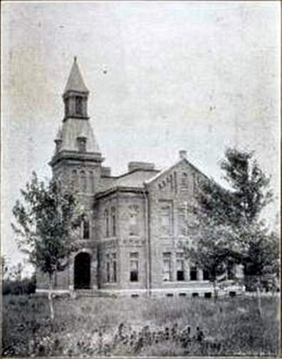
A second courthouse was built not long after the end of the Civil War. In February 1866, a contract was awarded for construction of a two-story brick building with cupola. Built at a cost of $40,000, it served the county until 1973.[13] By the mid-1890s, Keytesville had an estimated population of about 1,100 citizens. Two newspapers, the Chariton Courier and Keytesville Signal, served the community. Businesses included the Keytesville Roller Mill, a large water-powered grist mill on Muscle Fork Creek, two banks, a building and loan association, two hotels, a distillery, general mercantiles and restaurants.[7][8] Because of the town's location 1.5 mi (2.4 km) north of the Wabash Railroad line, Keytesville merchants encouraged the construction, in 1889, of a streetcar line. Hugo Bartz and J. J. Moore, secured land and financing for the project, which when completed consisted of two miles of track and a large barn for horses and rolling stock, constructed for a cost of $10,000.[7] Two horse-drawn passenger coaches and a large flatcar for freight delivered new arrivals at the Wabash depot to the town.
Keytesville today
While small, the town does have a business district, a public library, and chamber of commerce.[14] Included are a swimming pool, insurance sales, bank, convenience store, law offices, chiropractor, restaurant, auto repair, agricultural services and medical clinic.[8] The town has various service clubs and organizations, including the Lions Club. There are three sites in Keytesville listed on the National Register of Historic Places: the First Presbyterian Church, the Chariton County Jail and Sheriff's Residence, and the Redding-Hill House. Price Park features a statue of Sterling Price sculpted by Allen George Newman. A new Chariton County Courthouse was constructed in Keytesville in the summer of 1974 and occupied the following July. This was made necessary due to a fire that destroyed the previous Chariton County Courthouse on August 27, 1973.[13]
Government
Keytesville, a Missouri 4th class city, governs by a mayor-council system. Voters elect two aldermen from two wards, each serving a two-year term, and a mayor at-large, also for a two-year term.[8] The Keytesville Fire District, a volunteer force, provides fire protection for the town and surrounding rural area. law enforcement duties are handled by the Chariton County Sheriff's Department. The department headquarters and county jail are located in Keytesville. The city of Keytesville operates two parks. One of the parks provides camping opportunities with full hookup available.
Education
Keytesville R-III School district serves the town of Keytesville and surrounding rural area. Education in the community dates to before the Civil War, but many records indicating the exact date were lost in an 1861 fire at the county clerk's office.[15] In 1889, what might be considered the first modern-style school, a large 2-story building, was erected at a cost of $13,000[16] By 1909, Keytesville school was rated a first-class school by the state of Missouri. In 1949, a large number of the rural schools were combined with Keytesville to form the current district.[15] The current high school was constructed in 1959, with the current elementary school added in 1967. In 2010, the district had a total of 153 students K-12, and a graduation rate of 90-percent.[17] The school mascot is the Tiger and school colors are black and gold. Keytesville competes athletically in the Carroll-Livingston Activities Association. Its enrollment places the Tigers in Class 1 under Missouri State High School Activities Association guidelines.
Geography
Keytesville is located at the intersection of U.S. Route 24 and Missouri Route 5. It is 10 mi (16 km) east of Brunswick and 30 mi (48 km) west of Moberly.[18]
According to the United States Census Bureau, the city has a total area of 0.78 square miles (2.02 km2), of which 0.77 square miles (1.99 km2) is land and 0.01 square miles (0.03 km2) is water.[19]
Demographics
| Historical population | |||
|---|---|---|---|
| Census | Pop. | %± | |
| 1870 | 529 | — | |
| 1880 | 737 | 39.3% | |
| 1890 | 819 | 11.1% | |
| 1900 | 1,127 | 37.6% | |
| 1910 | 963 | −14.6% | |
| 1920 | 872 | −9.4% | |
| 1930 | 738 | −15.4% | |
| 1940 | 854 | 15.7% | |
| 1950 | 733 | −14.2% | |
| 1960 | 644 | −12.1% | |
| 1970 | 730 | 13.4% | |
| 1980 | 689 | −5.6% | |
| 1990 | 564 | −18.1% | |
| 2000 | 533 | −5.5% | |
| 2010 | 471 | −11.6% | |
| 2020 | 440 | −6.6% | |
| U.S. Decennial Census[20] | |||
2010 census
As of the census[21] of 2010, there were 471 people, 225 households, and 124 families residing in the city. The population density was 611.7 inhabitants per square mile (236.2/km2). There were 275 housing units at an average density of 357.1 per square mile (137.9/km2). The racial makeup of the city was 98.5% White, 0.6% African American, 0.4% Native American, and 0.4% Asian.
There were 225 households, of which 20.0% had children under the age of 18 living with them, 42.2% were married couples living together, 7.6% had a female householder with no husband present, 5.3% had a male householder with no wife present, and 44.9% were non-families. 40.0% of all households were made up of individuals, and 16.4% had someone living alone who was 65 years of age or older. The average household size was 2.07 and the average family size was 2.71.
The median age in the city was 46.4 years. 17.8% of residents were under the age of 18; 8.6% were between the ages of 18 and 24; 21.2% were from 25 to 44; 31.5% were from 45 to 64; and 21% were 65 years of age or older. The gender makeup of the city was 49.7% male and 50.3% female.
2000 census
As of the census[3] of 2000, there were 533 people, 253 households, and 129 families residing in the city. The population density was 764.8 people per square mile (294.0/km2). There were 295 housing units at an average density of 423.3 per square mile (162.7/km2). The racial makeup of the city was 95.31% White, 3.94% African American, 0.19% from other races, and 0.56% from two or more races. Hispanic or Latino of any race were 0.19% of the population.
There were 253 households, out of which 22.5% had children under the age of 18 living with them, 40.7% were married couples living together, 7.1% had a female householder with no husband present, and 49.0% were non-families. 45.5% of all households were made up of individuals, and 27.7% had someone living alone who was 65 years of age or older. The average household size was 2.07 and the average family size was 2.96.
In the city, the population was spread out, with 21.8% under the age of 18, 7.3% from 18 to 24, 23.3% from 25 to 44, 21.4% from 45 to 64, and 26.3% who were 65 years of age or older. The median age was 44 years. For every 100 females, there were 88.3 males. For every 100 females age 18 and over, there were 80.5 males.
The median income for a household in the city was $25,000, and the median income for a family was $35,568. Males had a median income of $25,156 versus $16,071 for females. The per capita income for the city was $14,699. About 10.9% of families and 16.4% of the population were below the poverty line, including 12.4% of those under age 18 and 17.0% of those age 65 or over.
Notable people from Keytesville
- Jane Hadley Barkley, wife of U.S. vice president Alben Barkley
- Cal Hubbard, member of both the Pro Football Hall of Fame, NFL Top 100, and National Baseball Hall of Fame and Museum
- Sterling Price, Missouri governor and Confederate general
- Maxwell D. Taylor, U.S. Army general and diplomat
- Lyda Southard, serial killer
19th-century Keytesville
 A portion of the Keytesville business district in 1896
 Sneed's Hotel, Keytesville, 1896
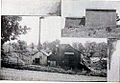 Big Spring Distillery, Keytesville, Missouri. Makers of "Old Chariton Rye" and "Ole Kentuck" whiskey, 1896
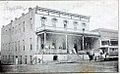 Hotel Snyder, Keytesville. Note the horse-drawn streetcar in the right corner, part of Keytesville's streetcar rail system


References
- "ArcGIS REST Services Directory". United States Census Bureau. Retrieved August 28, 2022.
- U.S. Geological Survey Geographic Names Information System: Keytesville, Missouri
- "U.S. Census website". United States Census Bureau. Retrieved 2008-01-31.
- "Find a County". National Association of Counties. Archived from the original on 2011-05-31. Retrieved 2011-06-07.
- "Explore Census Data". data.census.gov. Retrieved 2021-12-21.
- "Disappearing Missouri Names". The Kansas City Star. March 19, 1911. p. 15. Retrieved August 15, 2014 – via Newspapers.com.

- Historical, Pictorial, & Biographical Record of Chariton County, Missouri, Pictorial and Biographical Publishing Co., Salisbury Missouri, 1896
- "History of the city of Keytesville". Keytesville Area Chamber of Commerce. 2011. Archived from the original on 13 June 2012. Retrieved 5 August 2012.
- Castel, Albert E. with TH Goodrich, Bloody Bill Anderson: The Short Savage Life of a Civil War Guerrilla, Stackpole Books, 1998. pg. 60.
- The War of the Rebellion: A compilation of the official records of the Union Army., Written and published by the United States War Department. pp. 427-430
- FROM NORTHWEST MISSOURI.; Another Chapter of Pawpawism A Dark and Bloody Record Radical Union Men Warned to Leave the Country-They Vote at tho Peril of their Lives Murder and Arson in Chariton County. Missouri Democrat. October 2, 1864
- Lause, Mark A., Prices Lost Campaign: The 1864 Invasion of Missouri, University of Missouri Press, 2011, pg. 60.
- "Chariton County Courthouse profile". University of Missouri Extension. 2011. Retrieved 5 August 2012.
- "Missouri Public Libraries". PublicLibraries.com. Archived from the original on 10 June 2017. Retrieved 2 June 2019.
- "Keytesville School History". Keytesville R-III website. 2011. Archived from the original on 1 November 2012. Retrieved 5 August 2012.
- Chariton Courier, 29 May 1896.
- "Chariton County school districts data" (PDF). Keytesville Chamber of Commerce. 2011. Retrieved 5 August 2012.[permanent dead link]
- Missouri Atlas & Gazetteer, DeLorme, 1st ed., 1998, pp. 29-30 ISBN 0899332242
- "US Gazetteer files 2010". United States Census Bureau. Archived from the original on 2012-01-25. Retrieved 2012-07-08.
- "Census of Population and Housing". Census.gov. Retrieved June 4, 2015.
- "U.S. Census website". United States Census Bureau. Retrieved 2012-07-08.
External links
- Historic maps of Keytesville in the Sanborn Maps of Missouri Collection at the University of Missouri
Municipalities and communities of Chariton County, Missouri, United States | ||
|---|---|---|
County seat: Keytesville | ||
| Cities |  | |
| Villages |
| |
| Townships |
| |
| CDP |
| |
| Other communities |
| |
| Footnotes | ‡This populated place also has portions in an adjacent county or counties | |
| ||
Authority control | |
|---|---|
| General |
|
| National libraries | |
Другой контент может иметь иную лицензию. Перед использованием материалов сайта WikiSort.org внимательно изучите правила лицензирования конкретных элементов наполнения сайта.
WikiSort.org - проект по пересортировке и дополнению контента Википедии