world.wikisort.org - USA
Howevalley is an unincorporated community in Hardin County, Kentucky, United States. Howe Valley is located on Kentucky Route 86 12.3 miles (19.8 km) west of Elizabethtown.[2]
Howevalley, Kentucky | |
|---|---|
Unincorporated community | |
 Howevalley  Howevalley | |
| Coordinates: 37°41′14″N 86°05′18″W | |
| Country | United States |
| State | Kentucky |
| County | Hardin |
| Elevation | 682 ft (208 m) |
| Time zone | UTC-5 (Eastern (EST)) |
| • Summer (DST) | UTC-4 (EDT) |
| Area code(s) | 270 & 364 |
| GNIS feature ID | 494687[1] |
A post office operated in the community from 1852 to 1908. Howevalley (also historically spelled Howe's Valley and Howevalley) is situated in a valley of the same name, which in turn was named for John Howe, an early settler.[3] John Howe was in the American Revolutionary War and was given the land for his work.
References
- "Howe Valley". Geographic Names Information System. United States Geological Survey.
- State Primary Road System: Hardin County (PDF) (Map). Kentucky Transportation Cabinet. 2012. Retrieved May 1, 2013.
- Rennick, Robert M. (1987). Kentucky Place Names. University Press of Kentucky. p. 146. ISBN 0813126312. Retrieved 2013-04-28.
Municipalities and communities of Hardin County, Kentucky, United States | ||
|---|---|---|
County seat: Elizabethtown | ||
| Cities | 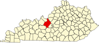 | |
| CDPs |
| |
| Other unincorporated communities |
| |
| Footnotes | ‡This populated place also has portions in an adjacent county or counties | |
| ||
This Hardin County, Kentucky state location article is a stub. You can help Wikipedia by expanding it. |
Текст в блоке "Читать" взят с сайта "Википедия" и доступен по лицензии Creative Commons Attribution-ShareAlike; в отдельных случаях могут действовать дополнительные условия.
Другой контент может иметь иную лицензию. Перед использованием материалов сайта WikiSort.org внимательно изучите правила лицензирования конкретных элементов наполнения сайта.
Другой контент может иметь иную лицензию. Перед использованием материалов сайта WikiSort.org внимательно изучите правила лицензирования конкретных элементов наполнения сайта.
2019-2026
WikiSort.org - проект по пересортировке и дополнению контента Википедии
WikiSort.org - проект по пересортировке и дополнению контента Википедии