world.wikisort.org - USA
Hoosierville is an unincorporated community in Jackson Township, Clay County, Indiana. It is part of the Terre Haute Metropolitan Statistical Area.
Hoosierville | |
|---|---|
Unincorporated community | |
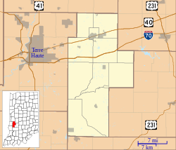
 Hoosierville Location in Clay County | |
| Coordinates: 39°28′30″N 87°06′30″W | |
| Country | United States |
| State | Indiana |
| County | Clay |
| Township | Jackson |
| Elevation | 653 ft (199 m) |
| ZIP code | 47834 |
| FIPS code | 18-34690[1] |
| GNIS feature ID | 436417[2] |
History
A post office was established at Hoosierville in 1874, and remained in operation until it was discontinued in 1902.[3] It was named from Indiana's official demonym, Hoosier.[4]
Mining was originally the primary industry of Hoosierville.[5]
Geography
Hoosierville is located at 39°28′30″N 87°06′30″W.
References
- "U.S. Census website". United States Census Bureau. Retrieved 2008-01-31.
- "Hoosierville, Indiana". Geographic Names Information System. United States Geological Survey. Retrieved 2009-10-17.
- "Clay County". Jim Forte Postal History. Retrieved 30 August 2014.
- Baker, Ronald L. (October 1995). From Needmore to Prosperity: Hoosier Place Names in Folklore and History. Indiana University Press. p. 171. ISBN 978-0-253-32866-3.
...named for its location in the Hoosier state.
- Blanchard, Charles (1884). Counties of Clay and Owen, Indiana: Historical and Biographical. F.A. Battey & Company. pp. 298.
Текст в блоке "Читать" взят с сайта "Википедия" и доступен по лицензии Creative Commons Attribution-ShareAlike; в отдельных случаях могут действовать дополнительные условия.
Другой контент может иметь иную лицензию. Перед использованием материалов сайта WikiSort.org внимательно изучите правила лицензирования конкретных элементов наполнения сайта.
Другой контент может иметь иную лицензию. Перед использованием материалов сайта WikiSort.org внимательно изучите правила лицензирования конкретных элементов наполнения сайта.
2019-2025
WikiSort.org - проект по пересортировке и дополнению контента Википедии
WikiSort.org - проект по пересортировке и дополнению контента Википедии
