world.wikisort.org - USA
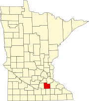
Hazelwood is an unincorporated community in Webster Township, Rice County, Minnesota, United States.
Hazelwood | |
|---|---|
Unincorporated community | |
 The Church of the Annunciation in Hazelwood | |
 Hazelwood Location of the community of Hazelwood within Webster Township, Rice County  Hazelwood Hazelwood (the United States) | |
| Coordinates: 44°31′21″N 93°17′10″W | |
| Country | United States |
| State | Minnesota |
| County | Rice County |
| Township | Webster Township |
| Elevation | 1,047 ft (319 m) |
| Time zone | UTC-6 (Central (CST)) |
| • Summer (DST) | UTC-5 (CDT) |
| ZIP code | 55057 |
| Area code(s) | 952 |
| GNIS feature ID | 644811[1] |
The community is located at the junction of Rice County Roads 3 and 46, near Interstate 35, 15 miles north of Faribault.
Dutch Creek flows through the community. Nearby places also include Lonsdale, Elko New Market, and Northfield.
ZIP codes 55088 (Webster) and 55057 (Northfield) meet near Hazelwood.
Hazelwood had a post office from 1857 to 1905, which was operated out of postmaster John J. McCabe's general store.[2]
References
- "Hazelwood, Minnesota". Geographic Names Information System. United States Geological Survey.
- "Hazelwood". Minnesota Historical Society. Retrieved March 21, 2012.
Текст в блоке "Читать" взят с сайта "Википедия" и доступен по лицензии Creative Commons Attribution-ShareAlike; в отдельных случаях могут действовать дополнительные условия.
Другой контент может иметь иную лицензию. Перед использованием материалов сайта WikiSort.org внимательно изучите правила лицензирования конкретных элементов наполнения сайта.
Другой контент может иметь иную лицензию. Перед использованием материалов сайта WikiSort.org внимательно изучите правила лицензирования конкретных элементов наполнения сайта.
2019-2025
WikiSort.org - проект по пересортировке и дополнению контента Википедии
WikiSort.org - проект по пересортировке и дополнению контента Википедии
