world.wikisort.org - USA
Greenville is an unincorporated community and census-designated place (CDP) in Love County, Oklahoma, United States. It was first listed as a CDP following the 2010 census.[2]
Greenville, Oklahoma | |
|---|---|
Census-designated place | |
 Greenville  Greenville | |
| Coordinates: 34°0′26″N 97°7′34″W | |
| Country | United States |
| State | Oklahoma |
| County | Love |
| Area | |
| • Total | 1.29 sq mi (3.34 km2) |
| • Land | 1.27 sq mi (3.30 km2) |
| • Water | 0.02 sq mi (0.04 km2) |
| Elevation | 760 ft (230 m) |
| Population (2020) | |
| • Total | 167 |
| • Density | 131.08/sq mi (50.63/km2) |
| Time zone | UTC-6 (Central (CST)) |
| • Summer (DST) | UTC-5 (CDT) |
| ZIP Code | 73448 (Marietta) |
| Area code | 580 |
| FIPS code | 40-31375 |
| GNIS feature ID | 2629921[2] |
The CDP is in northeastern Love County, along U.S. Route 77, 5 miles (8 km) north of Marietta, the county seat, and 12 miles (19 km) south of Ardmore. Interstate 35 passes just west of Greenville, with access from Exit 21 (Oswalt Road) 2 miles (3 km) to the north.
Demographics
| Historical population | |||
|---|---|---|---|
| Census | Pop. | %± | |
| 2020 | 167 | — | |
| U.S. Decennial Census[3] | |||
References
- "ArcGIS REST Services Directory". United States Census Bureau. Retrieved September 20, 2022.
- "Greenville Census Designated Place". Geographic Names Information System. United States Geological Survey, United States Department of the Interior.
- "Census of Population and Housing". Census.gov. Retrieved June 4, 2016.
Municipalities and communities of Love County, Oklahoma, United States | ||
|---|---|---|
County seat: Marietta | ||
| City | 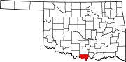 | |
| Towns | ||
| CDP | ||
| Other communities | ||
| Indian reservation |
| |
| Footnotes | ‡This populated place also has portions in an adjacent county or counties | |
| ||
This Oklahoma state location article is a stub. You can help Wikipedia by expanding it. |
Текст в блоке "Читать" взят с сайта "Википедия" и доступен по лицензии Creative Commons Attribution-ShareAlike; в отдельных случаях могут действовать дополнительные условия.
Другой контент может иметь иную лицензию. Перед использованием материалов сайта WikiSort.org внимательно изучите правила лицензирования конкретных элементов наполнения сайта.
Другой контент может иметь иную лицензию. Перед использованием материалов сайта WikiSort.org внимательно изучите правила лицензирования конкретных элементов наполнения сайта.
2019-2025
WikiSort.org - проект по пересортировке и дополнению контента Википедии
WikiSort.org - проект по пересортировке и дополнению контента Википедии