world.wikisort.org - USA
Greenville is a city and the county seat of Butler County, Alabama, United States. At the 2020 census, the population was 7,374. Greenville is known as the Camellia City, wherein originated the movement to change the official Alabama state flower from the goldenrod to the camellia with legislative sponsors LaMont Glass and H.B. Taylor.[2]
Greenville | |
|---|---|
City | |
 Butler County Courthouse in Greenville | |
| Nickname(s): Camellia City | |
 Location of Greenville in Butler County, Alabama. | |
| Coordinates: 31°49′52″N 86°37′39″W | |
| Country | United States |
| State | Alabama |
| County | Butler |
| Founded | 1819 |
| Government | |
| • Type | Mayor/Council |
| • Mayor | Dexter McLendon |
| Area | |
| • Total | 21.53 sq mi (55.76 km2) |
| • Land | 21.35 sq mi (55.31 km2) |
| • Water | 0.18 sq mi (0.46 km2) |
| Elevation | 440 ft (134 m) |
| Population (2020) | |
| • Total | 7,374 |
| • Density | 345.32/sq mi (133.33/km2) |
| Time zone | UTC-6 (Central (CST)) |
| • Summer (DST) | UTC-5 (CDT) |
| ZIP code | 36037 |
| Area code | 334 |
| FIPS code | 01-31912 |
| GNIS feature ID | 0119376 |
| Website | www |
History
Greenville was first settled in 1819. Its original name was Buttsville,[3] but after becoming the county seat in 1822, its name was changed to Greenville, in remembrance of the former locale in South Carolina of many of the original settlers.[4][5] The first county seat was at Fort Dale, a fortification that was named for Sam Dale, who fought to defend the area during the Creek War. The site of Fort Dale lies on the north of the city near the Fort Dale Cemetery, along what is now Alabama Highway 185.
The namesake of the county, Captain William Butler, was killed during the Creek War. He is buried in the Pioneer Cemetery, which is across from the oldest church in Butler County, the First United Methodist Church of Greenville.
During World War II, a satellite camp for German prisoners was based in Greenville.[6]
Geography
Greenville is located in southern Alabama at 31°49'52.583" North, 86°37'39.241" West (31.831273, -86.627567).[7] Interstate 65 passes to the west of the city center, with access from exits 128 and 130. U.S. Route 31 passes to the east of the city center. Montgomery, the state capital, is 44 miles (71 km) northeast, the closest city to Greenville with a population above 50,000.[8] Mobile is 127 miles (204 km) to the southwest on I-65.
According to the U.S. Census Bureau, Greenville has a total area of 21.5 square miles (55.8 km2), of which 21.4 square miles (55.3 km2) is land and 0.19 square miles (0.5 km2), or 0.82%, is water.[9]
Climate
The city of Greenville has a humid subtropical climate, with an average high temperature of 77.3 °F (25.2 °C) and an average low temperature of 53.8 °F (12.1 °C). The city averages 4.80 inches (122 mm) of precipitation per month.[10]
| Climate data for Greenville, Alabama | |||||||||||||
|---|---|---|---|---|---|---|---|---|---|---|---|---|---|
| Month | Jan | Feb | Mar | Apr | May | Jun | Jul | Aug | Sep | Oct | Nov | Dec | Year |
| Record high °F (°C) | 83 (28) |
86 (30) |
89 (32) |
96 (36) |
100 (38) |
108 (42) |
106 (41) |
105 (41) |
103 (39) |
100 (38) |
91 (33) |
86 (30) |
108 (42) |
| Average high °F (°C) | 59 (15) |
64 (18) |
72 (22) |
78 (26) |
85 (29) |
90 (32) |
92 (33) |
92 (33) |
87 (31) |
79 (26) |
69 (21) |
61 (16) |
77 (25) |
| Average low °F (°C) | 37 (3) |
40 (4) |
46 (8) |
52 (11) |
60 (16) |
67 (19) |
70 (21) |
69 (21) |
65 (18) |
54 (12) |
46 (8) |
39 (4) |
54 (12) |
| Record low °F (°C) | −1 (−18) |
9 (−13) |
15 (−9) |
28 (−2) |
38 (3) |
48 (9) |
56 (13) |
50 (10) |
38 (3) |
29 (−2) |
11 (−12) |
5 (−15) |
−1 (−18) |
| Average precipitation inches (mm) | 5.97 (152) |
5.08 (129) |
6.75 (171) |
4.19 (106) |
4.12 (105) |
4.88 (124) |
5.51 (140) |
4.30 (109) |
4.56 (116) |
2.69 (68) |
4.67 (119) |
4.90 (124) |
57.62 (1,463) |
| Average snowfall inches (cm) | 0 (0) |
0.4 (1.0) |
0 (0) |
0 (0) |
0 (0) |
0 (0) |
0 (0) |
0 (0) |
0 (0) |
0 (0) |
0 (0) |
0 (0) |
0.4 (1.0) |
| Source: [11] | |||||||||||||
Demographics
| Historical population | |||
|---|---|---|---|
| Census | Pop. | %± | |
| 1870 | 2,856 | — | |
| 1880 | 2,471 | −13.5% | |
| 1890 | 2,806 | 13.6% | |
| 1900 | 3,162 | 12.7% | |
| 1910 | 3,377 | 6.8% | |
| 1920 | 3,471 | 2.8% | |
| 1930 | 3,985 | 14.8% | |
| 1940 | 5,075 | 27.4% | |
| 1950 | 6,731 | 32.6% | |
| 1960 | 6,894 | 2.4% | |
| 1970 | 8,033 | 16.5% | |
| 1980 | 7,807 | −2.8% | |
| 1990 | 7,492 | −4.0% | |
| 2000 | 7,228 | −3.5% | |
| 2010 | 8,135 | 12.5% | |
| 2020 | 7,374 | −9.4% | |
| U.S. Decennial Census[12] | |||
2020 census
| Race | Num. | Perc. |
|---|---|---|
| White | 2,624 | 35.58% |
| Black or African American | 4,292 | 58.2% |
| Native American | 8 | 0.11% |
| Asian | 118 | 1.6% |
| Pacific Islander | 2 | 0.03% |
| Other/Mixed | 197 | 2.67% |
| Hispanic or Latino | 133 | 1.8% |
As of the 2020 United States Census, there were 7,374 people, 2,356 households, and 1,496 families residing in the city.
2010 census
As of the census[14] of 2010, there were 8,135 people, 3,332 households, and 2,126 families residing in the city. The racial makeup of the city was 55.5% Black or African American, 41.7% White, 0.0% Native American, 1.8% Asian, 0.5% from other races, and 0.5% from two or more races. 1.3% of the population were Hispanic or Latino of any race.
In the city, 27.3% of the population was under the age of 18, 8.6% were 18 to 24, 25.0% were 25 to 44, 24.4% were 45 to 64, and 14.8% were 65 years of age or older. The median age was 35.3. For every 100 females, there were 82.2 males. For every 100 females age 18 and over, there were 78.7 males.
There were 3,332 households. Of those, 31.6% had children under the age of 18 living with them, 35.0% were married couples living together, 25.3% had a female householder with no husband present, and 36.2% were non-families. 33.3% of all households were made up of individuals, and 13.1% had someone living alone who was 65 years of age or older. The average household size was 2.40 and the average family size was 3.06.
The median income for a household in the city was $26,664, and the median income for a family was $31,107. Males had a median income of $33,716 versus $24,928 for females. The per capita income for the city was $15,649. About 20.3% of families and 24.9% of the population were below the poverty line, including 30.1% of those under age 18 and 20.9% of those age 65 or over.
Education
Primary and secondary education
Public education is provided by the Butler County Board of Education.[15]
- High School: Greenville High School
- Middle School: Greenville Middle School
- Elementary School: W.O. Parmer Elementary and Greenville Elementary School
Private schools in Greenville include Fort Dale Academy[16] and Camellia City Christian School.
Post-secondary education
- Lurleen B. Wallace Community College, member of the Alabama Community College System awards two-year associate degrees and professional certificates.[17]
Economy
Prior to the Civil War, cotton farming was the main occupation in Butler County. During the 1850s lines along the Mobile and Ohio Railroad were constructed, making the county a major trading center. Greenville was a railroad town and became the center of commerce between Montgomery and south Alabama. During the late nineteenth century, the construction of the Louisville and Nashville Railroad through Greenville contributed further to the town's success. At the turn of the century, Gulf Red Cedar Company and Factory in Greenville became a noted bucket manufacturing enterprise.
Today, Greenville has a diverse industrial manufacturing base of companies in the textile, wood products, automobile, and other industries. Major employers include Hwashin American Corporation, Hysco America Corporation, CorStone Industry, and Connector Manufacturing.[18]
Law and government
The local government of Greenville is run by the Mayor and City Council. The city council consists of five members each elected from single member districts. The city is located in Alabama's 2nd Congressional District and is currently represented by U.S. Representative Barry Moore.[19]
Media
Radio stations
- WGYV 1380 AM (Talk)
- WKXN 95.7 FM (Urban Contemporary)
- WQZX 94.3 FM
WGYV has applied to relocate its license to Aurora, Indiana.[20]
Newspaper
- The Greenville Standard (weekly)
- Greenville Advocate (weekly)
Recreation and culture
Greenville was a common setting in the 2002 movie Sweet Home Alabama. None of the movie was actually filmed in Greenville.
The city's residents were featured on the premiere episode of the ABC reality/game show series My Kind of Town, on Sunday, August 14, 2005.
The 2007 movie Honeydripper was shot in locations around Greenville in late summer and fall of 2006. The film featured sites located on Main Street in the city's historic downtown. Local residents were selected as principal characters and extras for the movie. New Beginnings Ministry's church choir was featured in the film.[21]
Located in Greenville is the historic Ritz Theatre, a local theatre where community events and plays can be performed for the city.[22] Annually, the city's Area Arts Council will perform a musical revue by the name of "Puttin' on the Ritz" which has a different theme each year.[23]
Greenville is the location of a Robert Trent Jones-designed golf course, Cambrian Ridge, 7 miles (11 km) northwest of downtown, and to Sherling Lake Park and Campground which has 41 campsites and surrounds two lakes just east of the golf course.
Greenville is also the home of the Watermelon Jubilee, a local arts and crafts exposition held each year in the month of August. Every year in September, the city hosts the Butler County Fair. Also, during the fall, Greenville hosts Old Time Farm Day which features activities such as tractor races, blacksmithing and quilting demonstrations.[24] Watermelon Jubilee no longer held
Notable people
This section needs additional citations for verification. (October 2020) |
- Janice Rogers Brown, Judge of the United States Court of Appeals for the District of Columbia Circuit
- Beth Chapman, Secretary of State of Alabama from 2007 to 2013
- Leon Crenshaw, former defensive tackle for the Green Bay Packers
- Marlon Davidson, defensive tackle for the Atlanta Falcons
- Walter Flowers, member of the United States House of Representatives from 1969 to 1979
- Phil Hancock, professional golfer
- Johnny Lewis, former outfielder for the St. Louis Cardinals and New York Mets
- Tommy Lewis, former American football fullback and coach
- George McMillan, 23rd Lieutenant Governor of Alabama
- Mark Matthews, World War II veteran and Buffalo Soldier
- Rufus Payne, blues musician
- Lewis B. Porterfield, Rear admiral in the United States Navy
- Bill Powell, first African American to design, construct and own a professional golf course in the United States
- Marty Raybon, country music singer of the group Shenandoah
- Za’Darius Smith, linebacker for the Minnesota Vikings
- Thomas H. Watts, eighteenth governor of Alabama
- Hank Williams, country music singer lived in Greenville briefly during childhood
- Ed Bell (musician), country blues singer and guitarist
Gallery
- Greenville, Alabama
 View of the old L&N train depot
 View of Confederate Park
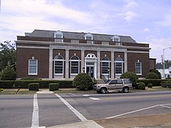 View of Greenville Post Office
 View of Greenville City Hall


See also
- National Register of Historic Places listings in Butler County, Alabama
References
- "2020 U.S. Gazetteer Files". United States Census Bureau. Retrieved October 29, 2021.
- "Camellia Day". The Office of Alabama Governor Robert Bentley. Retrieved January 15, 2016.
- "Alabama Counties: Butler County". Alabama Department of Archives and History. Retrieved January 7, 2010.
- "History". City of Greenville, Alabama. Retrieved January 7, 2010.
- Gannett, Henry (1905). The Origin of Certain Place Names in the United States. Govt. Print. Off. pp. 144.
- Hutchinson, Daniel (October 6, 2009). "World War II POW Camps in Alabama". Encyclopedia of Alabama. Retrieved January 7, 2010.
- "US Gazetteer files: 2010, 2000, and 1990". United States Census Bureau. February 12, 2011. Retrieved April 23, 2011.
- "Greenville-Alabama" Archived March 11, 2010, at the Wayback Machine Retrieved April 14, 2010
- "Geographic Identifiers: 2010 Demographic Profile Data (G001): Greenville city, Alabama". U.S. Census Bureau, American Factfinder. Archived from the original on February 12, 2020. Retrieved September 18, 2013.
- "Climate-Charts" Archived 2012-02-27 at the Wayback Machine Retrieved April 13, 2010
- "Intellicast | Weather Underground".
- "U.S. Decennial Census". Census.gov. Retrieved June 6, 2013.
- "Explore Census Data". data.census.gov. Retrieved 2021-12-08.
- "U.S. Census website". United States Census Bureau. Retrieved July 9, 2015.
- "Butler County Schools / Homepage".
- "Fort Dale Academy".
- "About LBWCC". Lurleen B. Wallace Community College. Retrieved January 8, 2010.
- "Butler County". Encyclopedia of Alabama. December 10, 2009. Retrieved January 7, 2010.
- Alabama's 2nd congressional district
- "Application Search Details (BMJP-20051031AGM)". FCC Media Bureau. August 6, 2008.
- Archived September 17, 2010, at the Wayback Machine"Alabama Blues Project" Retrieved April 11, 2010
- "Greenville: Ritz Theatre" Retrieved July 25, 2016
- "GAAC: Ritz Players" Retrieved July 25, 2016
- "Greenville-Alabama" Archived March 11, 2010, at the Wayback Machine Retrieved April 13, 2010
External links
- City of Greenville official website
- The Greenville Standard
- The Greenville Advocate
- Article on Greenville by Senator Russ Feingold (D-WI) in Salon magazine
Municipalities and communities of Butler County, Alabama, United States | ||
|---|---|---|
County seat: Greenville | ||
| City |  | |
| Towns |
| |
| Unincorporated communities | ||
| Footnotes | ‡This populated place also has portions in an adjacent county or counties | |
| ||
Authority control | |
|---|---|
| General | |
| National libraries | |
| Other |
|
Другой контент может иметь иную лицензию. Перед использованием материалов сайта WikiSort.org внимательно изучите правила лицензирования конкретных элементов наполнения сайта.
WikiSort.org - проект по пересортировке и дополнению контента Википедии