world.wikisort.org - USA
Garrison is an unincorporated community and census-designated place in Lewis County, Kentucky, United States. Its population was 866 as of the 2010 census.[3] Garrison has a post office with ZIP code 41141, which opened on February 26, 1886.[4][5] The community is located along the Ohio River and Kentucky Route 8.
Garrison, Kentucky | |
|---|---|
Census-designated place | |
 Garrison  Garrison | |
| Coordinates: 38°36′22″N 83°10′24″W | |
| Country | United States |
| State | Kentucky |
| County | Lewis |
| Area | |
| • Total | 2.76 sq mi (7.16 km2) |
| • Land | 2.70 sq mi (6.98 km2) |
| • Water | 0.07 sq mi (0.17 km2) |
| Elevation | 538 ft (164 m) |
| Population (2020) | |
| • Total | 731 |
| • Density | 271.14/sq mi (104.68/km2) |
| Time zone | UTC-5 (Eastern (EST)) |
| • Summer (DST) | UTC-4 (EDT) |
| ZIP code | 41141 |
| Area code(s) | 606 |
| GNIS feature ID | 492728[2] |
Geography
According to the U.S. Census Bureau, the community has an area of 2.763 square miles (7.16 km2); 2.696 square miles (6.98 km2) of its area is land, and 0.067 square miles (0.17 km2) is water.[3]
Demographics
| Historical population | |||
|---|---|---|---|
| Census | Pop. | %± | |
| 2020 | 731 | — | |
Notable people
- Thomas Massie, congressman[7]
References
- "2020 U.S. Gazetteer Files". United States Census Bureau. Retrieved March 18, 2022.
- "Garrison". Geographic Names Information System. United States Geological Survey.
- "2010 Census Gazetteer Files - Places: Kentucky". U.S. Census Bureau. Retrieved April 2, 2017.
- United States Postal Service. "USPS - Look Up a ZIP Code". Retrieved April 2, 2017.
- "Postmaster Finder - Post Offices by ZIP Code". United States Postal Service. Retrieved April 2, 2017.
- "Census of Population and Housing". Census.gov. Retrieved June 4, 2016.
- Wartman, Scott (February 8, 2018). "Thomas Massie powers his house with a Tesla battery. And the Congressman made a video about it". The Cincinnati Enquirer. Retrieved October 13, 2020.
Municipalities and communities of Lewis County, Kentucky, United States | ||
|---|---|---|
County seat: Vanceburg | ||
| Cities | 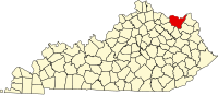 | |
| CDP | ||
| Other unincorporated communities |
| |
| ||
This Lewis County, Kentucky state location article is a stub. You can help Wikipedia by expanding it. |
Текст в блоке "Читать" взят с сайта "Википедия" и доступен по лицензии Creative Commons Attribution-ShareAlike; в отдельных случаях могут действовать дополнительные условия.
Другой контент может иметь иную лицензию. Перед использованием материалов сайта WikiSort.org внимательно изучите правила лицензирования конкретных элементов наполнения сайта.
Другой контент может иметь иную лицензию. Перед использованием материалов сайта WikiSort.org внимательно изучите правила лицензирования конкретных элементов наполнения сайта.
2019-2026
WikiSort.org - проект по пересортировке и дополнению контента Википедии
WikiSort.org - проект по пересортировке и дополнению контента Википедии