world.wikisort.org - USA
Franklin Township is a civil township of Lenawee County in the U.S. state of Michigan. The population was 2,939 at the 2000 census.[2]
Franklin Township, Michigan | |
|---|---|
Civil township | |
 Franklin Township Hall along M-50 | |
 Location within Lenawee County | |
 Franklin Township Location within the state of Michigan  Franklin Township Franklin Township (the United States) | |
| Coordinates: 42°01′53″N 84°04′28″W | |
| Country | United States |
| State | Michigan |
| County | Lenawee |
| Government | |
| • Supervisor | Daniel VanValkenburg |
| • Clerk | Susan Whitehead |
| Area | |
| • Total | 39.3 sq mi (101.8 km2) |
| • Land | 38.5 sq mi (99.7 km2) |
| • Water | 0.8 sq mi (2.2 km2) |
| Elevation | 958 ft (292 m) |
| Population (2000)[2] | |
| • Total | 2,939 |
| • Density | 76.4/sq mi (29.5/km2) |
| Time zone | UTC-5 (Eastern (EST)) |
| • Summer (DST) | UTC-4 (EDT) |
| ZIP code(s) | 49221 (Adrian) 49236 (Clinton) 49265 (Onsted) 49286 (Tecumseh) 49287 (Tipton) |
| FIPS code | 26-30320[3] |
| GNIS feature ID | 1626308[1] |
| Website | www |
Communities
- Evans Lake was a post office here from 1890 until 1900.[4]
- Tipton is an unincorporated community in the township at the junction of M-50 and Tipton Highway at 42°01′00″N 84°03′51″W.[5] The community was founded by the Rev. Henry Tripp in 1831. It was first known as Franklin Center, after Benjamin Franklin (and for whom the township is named). It was renamed Tripp Town and then shortened to Tipton. A post office was opened June 6, 1834, with William Camburn as the first postmaster.[6][7] The Tipton ZIP code 49287 also serves most of Franklin Township, as well as small areas of northeast Cambridge Township, southwest Manchester Township, and north central Adrian Township.[8]
- The city of Adrian is to the south, and the Adrian ZIP code 49221 also serves portions of southern Franklin Township.[9]
- The village of Clinton is to the east and the Clinton ZIP code 49236 also serves portions of northeastern Franklin Township.[10]
- The village of Onsted is to the west and the Onsted ZIP code 49265 also serves portions of western Franklin Township.[11]
- The city of Tecumseh is to the east, and the Tecumseh ZIP code 49286 also serves portions of eastern Franklin Township.[12]
Geography
According to the United States Census Bureau, the township has a total area of 39.3 square miles (101.8 km2), of which 38.5 square miles (99.7 km2) is land and 0.8 square mile (2.1 km2) (2.11%) is water.
Demographics
As of the census[3] of 2000, there were 2,939 people, 1,071 households, and 846 families residing in the township. The population density was 76.4 per square mile (29.5/km2). There were 1,275 housing units at an average density of 33.1 per square mile (12.8/km2). The racial makeup of the township was 98.03% White, 0.07% African American, 0.10% Native American, 0.31% Asian, 0.48% from other races, and 1.02% from two or more races. Hispanic or Latino of any race were 1.09% of the population.
There were 1,071 households, out of which 36.4% had children under the age of 18 living with them, 68.3% were married couples living together, 7.1% had a female householder with no husband present, and 21.0% were non-families. 17.1% of all households were made up of individuals, and 5.5% had someone living alone who was 65 years of age or older. The average household size was 2.74 and the average family size was 3.08.
In the township the population was spread out, with 27.2% under the age of 18, 6.2% from 18 to 24, 30.4% from 25 to 44, 26.9% from 45 to 64, and 9.4% who were 65 years of age or older. The median age was 38 years. For every 100 females, there were 102.0 males. For every 100 females age 18 and over, there were 102.5 males.
The median income for a household in the township was $56,296, and the median income for a family was $61,979. Males had a median income of $47,083 versus $25,691 for females. The per capita income for the township was $24,300. About 1.6% of families and 2.7% of the population were below the poverty line, including 1.7% of those under age 18 and 3.0% of those age 65 or over.
Gallery
 Former Franklin Township Hall
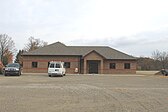 New Township Hall under construction in 2010
 U.S. Post Office in Tipton
 Community of Tipton along M-50
 The Keeney Farm
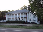 The Davenport House


References
- U.S. Geological Survey Geographic Names Information System: Franklin Township, Lenawee County, Michigan
- Franklin township, Lenawee County, Michigan Fact Sheet Archived 2020-02-16 at archive.today, United States Census Bureau
- "U.S. Census website". United States Census Bureau. Retrieved 2008-01-31.
- Romig, Michigan Place Names, p. 188
- U.S. Geological Survey Geographic Names Information System: Tipton, Michigan
- Romig, Walter (1986) [1973]. Michigan Place Names. Detroit, Michigan: Wayne State University Press. ISBN 0-8143-1838-X.
- U.S. Geological Survey Geographic Names Information System: Tipton Post Office
- 49287 5-Digit ZCTA, 492 3-Digit ZCTA - Reference Map - American FactFinder[permanent dead link], U.S. Census Bureau, 2000 census
- 49221 5-Digit ZCTA, 492 3-Digit ZCTA - Reference Map - American FactFinder[permanent dead link], U.S. Census Bureau, 2000 census
- 49236 5-Digit ZCTA, 492 3-Digit ZCTA - Reference Map - American FactFinder[permanent dead link], U.S. Census Bureau, 2000 census
- 49265 5-Digit ZCTA, 492 3-Digit ZCTA - Reference Map - American FactFinder[permanent dead link], U.S. Census Bureau, 2000 census
- 49286 5-Digit ZCTA, 492 3-Digit ZCTA - Reference Map - American FactFinder[permanent dead link], U.S. Census Bureau, 2000 census
External links
- Franklin Township government site
- Lenawee County government site
- Complete text of History of Lenawee County published in 1909 by the Western Historical Society
Municipalities and communities of Lenawee County, Michigan, United States | ||
|---|---|---|
County seat: Adrian | ||
| Cities |
|  |
| Villages |
| |
| Charter townships |
| |
| Civil townships | ||
| CDPs |
| |
| Other unincorporated communities |
| |
| Footnotes | ‡This populated place also has portions in an adjacent county or counties | |
| ||
Другой контент может иметь иную лицензию. Перед использованием материалов сайта WikiSort.org внимательно изучите правила лицензирования конкретных элементов наполнения сайта.
WikiSort.org - проект по пересортировке и дополнению контента Википедии