world.wikisort.org - USA
Falmouth is an unincorporated community and census-designated place (CDP) in Missaukee County in the U.S. state of Michigan.[2] The community is located within Clam Union Township.
Falmouth, Michigan
Pinhook or Clam Union | |
|---|---|
Census-designated place (CDP) & unincorporated community | |
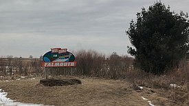
 Welcome sign to Falmouth (February 2018) | |
 Falmouth Location within the state of Michigan##Location within the United States | |
| Coordinates: 44°14′36″N 85°05′13″W | |
| Country | United States |
| State | Michigan |
| County | Missaukee |
| Township | Clam Union |
| Settled | 1871 |
| Area | |
| • Total | 0.68 sq mi (1.76 km2) |
| • Land | 0.68 sq mi (1.76 km2) |
| • Water | 0.00 sq mi (0.00 km2) |
| Population (2020) | |
| • Total | 183 |
| • Density | 269.12/sq mi (103.95/km2) |
| Time zone | UTC-5 (Eastern (EST)) |
| • Summer (DST) | UTC-4 (EDT) |
| ZIP code(s) | 49632 |
| Area code | 231 |
| GNIS feature ID | 625817[2] |
History
It began as a lumbering settlement and was first known as "Pinhook". A post office named Falmouth was established on December 18, 1871,[3] with Eugene W. Watson as the first postmaster. In 1873, Falmouth nearly became the county seat, losing to Reeder (now Lake City) by one vote. John Koopman built a store in 1879, and in 1881 bought the village plat, along with its saw, shingle and grist mill.[4]
Geography
The Falmouth post office, with ZIP code 49632, also serves portions of northern and eastern Clam Union Township, as well as all of Holland Township to the east, and portions of Butterfield Township to the northeast, Aetna Township to the north, and smaller areas in Reeder Township to the northwest and Riverside Township to the west.[5]
Demographics
| Historical population | |||
|---|---|---|---|
| Census | Pop. | %± | |
| 2020 | 183 | — | |
| U.S. Decennial Census[6] | |||
Transportation
The main roads that provide access to Falmouth are Prosper Road (to the east), 7 Mile Road (to the northeast), Forward Road (to the north and south), and Falmouth Road (to the west.
Nearby major highways
 M-66
M-66 M-55
M-55
References
- "2020 U.S. Gazetteer Files". United States Census Bureau. Retrieved May 21, 2022.
- U.S. Geological Survey Geographic Names Information System: Falmouth, Michigan
- U.S. Geological Survey Geographic Names Information System: Falmouth Post Office
- Romig, Walter (1986) [1973]. Michigan Place Names. Detroit, Michigan: Wayne State University Press. ISBN 0-8143-1838-X.
- 49632 5-Digit ZCTA, 496 3-Digit ZCTA - Reference Map - American FactFinder[permanent dead link], U.S. Census Bureau, 2000 census
- "Census of Population and Housing". Census.gov. Retrieved June 4, 2016.
Другой контент может иметь иную лицензию. Перед использованием материалов сайта WikiSort.org внимательно изучите правила лицензирования конкретных элементов наполнения сайта.
WikiSort.org - проект по пересортировке и дополнению контента Википедии
