world.wikisort.org - USA
Falls City is a city in Polk County, Oregon, United States. The population was 947 at the 2010 census. It is part of the Salem Metropolitan Statistical Area.
This article uses bare URLs, which are uninformative and vulnerable to link rot. (August 2022) |
Falls City, Oregon | |
|---|---|
City | |
 Fire department in Falls City | |
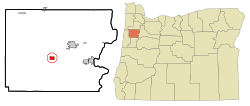 Location in Oregon | |
| Coordinates: 44°51′58″N 123°26′19″W | |
| Country | United States |
| State | Oregon |
| County | Polk |
| Incorporated | 1893 |
| Government | |
| • Mayor | Jeremy Gordon |
| Area | |
| • Total | 1.20 sq mi (3.11 km2) |
| • Land | 1.20 sq mi (3.11 km2) |
| • Water | 0.00 sq mi (0.00 km2) |
| Elevation | 370 ft (112.8 m) |
| Population (2020)[2] | |
| • Total | 1,051 |
| • Density | 874.38/sq mi (337.72/km2) |
| Time zone | UTC-8 (Pacific) |
| • Summer (DST) | UTC-7 (Pacific) |
| ZIP code | 97344 |
| Area code | 503 |
| FIPS code | 41-24550[3] |
| GNIS feature ID | 1162976[4] |
| Website | www.fallscityoregon.gov |
History

It is part of the Dallas micropolitan statistical area. Falls City is named after a waterfall in the Little Luckiamute River that passes through the center of town. In the past it was a lumbermill town and once had three mills in operation, a bank, hotel, soda shop, jail, and several grocery stores and bars. It formerly supported a large logging population and other population centers in the hills of the Coast Range, such as the smaller lumber-based community of Black Rock and the company-owned mill town Valsetz.[5][6]
Geography
According to the United States Census Bureau, the city has a total area of 1.20 square miles (3.11 km2), all of it land.[7]
Climate
The city of Falls City experiences warm and dry summers, and cold and wet winters, with no average monthly temperatures above 71.6 °F or 22 °C. According to the Köppen Climate Classification, Falls City has a warm-summer Mediterranean climate, abbreviated Csb on climate maps.[8]
| Climate data for Falls City | |||||||||||||
|---|---|---|---|---|---|---|---|---|---|---|---|---|---|
| Month | Jan | Feb | Mar | Apr | May | Jun | Jul | Aug | Sep | Oct | Nov | Dec | Year |
| Record high °F (°C) | 68 (20) |
67 (19) |
82 (28) |
88 (31) |
94 (34) |
102 (39) |
106 (41) |
102 (39) |
100 (38) |
90 (32) |
74 (23) |
63 (17) |
106 (41) |
| Average high °F (°C) | 44.6 (7.0) |
49.2 (9.6) |
53.9 (12.2) |
60.4 (15.8) |
66.6 (19.2) |
71.7 (22.1) |
80.4 (26.9) |
80.4 (26.9) |
74.3 (23.5) |
63.3 (17.4) |
52.2 (11.2) |
46.2 (7.9) |
61.9 (16.6) |
| Average low °F (°C) | 31.5 (−0.3) |
33.3 (0.7) |
35.3 (1.8) |
37.9 (3.3) |
41.8 (5.4) |
45.9 (7.7) |
48.4 (9.1) |
48.2 (9.0) |
46.4 (8.0) |
42 (6) |
36.2 (2.3) |
33.4 (0.8) |
40 (4) |
| Record low °F (°C) | −5 (−21) |
1 (−17) |
18 (−8) |
23 (−5) |
26 (−3) |
26 (−3) |
36 (2) |
36 (2) |
26 (−3) |
23 (−5) |
10 (−12) |
−2 (−19) |
−5 (−21) |
| Average precipitation inches (mm) | 12.49 (317) |
10.19 (259) |
9.16 (233) |
4.36 (111) |
2.65 (67) |
1.5 (38) |
0.3 (7.6) |
0.56 (14) |
1.9 (48) |
5.22 (133) |
11.81 (300) |
13.61 (346) |
73.75 (1,873) |
| Average snowfall inches (cm) | 7.8 (20) |
2.8 (7.1) |
2.3 (5.8) |
0 (0) |
0 (0) |
0 (0) |
0 (0) |
0 (0) |
0 (0) |
0.1 (0.25) |
0.5 (1.3) |
2.4 (6.1) |
16 (41) |
| Average precipitation days | 19 | 16 | 18 | 13 | 11 | 7 | 2 | 3 | 6 | 12 | 17 | 19 | 143 |
| Source: [9] | |||||||||||||
Demographics
| Historical population | |||
|---|---|---|---|
| Census | Pop. | %± | |
| 1900 | 269 | — | |
| 1910 | 969 | 260.2% | |
| 1920 | 994 | 2.6% | |
| 1930 | 494 | −50.3% | |
| 1940 | 715 | 44.7% | |
| 1950 | 853 | 19.3% | |
| 1960 | 653 | −23.4% | |
| 1970 | 745 | 14.1% | |
| 1980 | 804 | 7.9% | |
| 1990 | 818 | 1.7% | |
| 2000 | 966 | 18.1% | |
| 2010 | 947 | −2.0% | |
| 2020 | 1,051 | 11.0% | |
| U.S. Decennial Census[10][2] | |||

2010 census
As of the census[11] of 2010, there were 947 people, 366 households, and 261 families residing in the city. The population density was 789.2 inhabitants per square mile (304.7/km2). There were 395 housing units at an average density of 329.2 per square mile (127.1/km2). The racial makeup of the city was 91.6% White, 0.1% African American, 2.3% Native American, 0.4% Asian, 0.1% Pacific Islander, 1.8% from other races, and 3.7% from two or more races. Hispanic or Latino of any race were 5.2% of the population.
There were 366 households, of which 30.3% had children under the age of 18 living with them, 54.4% were married couples living together, 10.4% had a female householder with no husband present, 6.6% had a male householder with no wife present, and 28.7% were non-families. 22.7% of all households were made up of individuals, and 7.6% had someone living alone who was 65 years of age or older. The average household size was 2.59 and the average family size was 2.98.
The median age in the city was 43.5 years. 22.9% of residents were under the age of 18; 8% were between the ages of 18 and 24; 21% were from 25 to 44; 31.9% were from 45 to 64; and 16.3% were 65 years of age or older. The gender makeup of the city was 51.5% male and 48.5% female.
2000 census
As of the census[3] of 2000, there were 966 people, 338 households, and 255 families residing in the city. The population density was 785.2 people per square mile (303.2/km2). There were 373 housing units at an average density of 303.2 per square mile (117.1/km2). The racial makeup of the city was 92.86% White, 0.93% African American, 1.66% Native American, 0.10% Asian, 0.21% Pacific Islander, 1.04% from other races, and 3.21% from two or more races. Hispanic or Latino of any race were 3.62% of the population.
There were 338 households, out of which 35.2% had children under the age of 18 living with them, 58.3% were married couples living together, 13.6% had a female householder with no husband present, and 24.3% were non-families. 19.2% of all households were made up of individuals, and 9.5% had someone living alone who was 65 years of age or older. The average household size was 2.86 and the average family size was 3.25.
In the city, the population was spread out, with 31.0% under the age of 18, 5.5% from 18 to 24, 26.7% from 25 to 44, 22.4% from 45 to 64, and 14.5% who were 65 years of age or older. The median age was 38 years. For every 100 females, there were 91.7 males. For every 100 females age 18 and over, there were 88.4 males.
The median income for a household in the city was $32,461, and the median income for a family was $36,528. Males had a median income of $31,827 versus $26,429 for females. The per capita income for the city was $13,858. About 11.6% of families and 15.8% of the population were below the poverty line, including 16.5% of those under age 18 and 9.0% of those age 65 or over.
References
- "ArcGIS REST Services Directory". United States Census Bureau. Retrieved October 12, 2022.
- "Census Population API". United States Census Bureau. Retrieved Oct 12, 2022.
- "U.S. Census website". United States Census Bureau. Retrieved 2008-01-31.
- "US Board on Geographic Names". United States Geological Survey. 2007-10-25. Retrieved 2008-01-31.
- http://www.polkcountyhistoricalsociety.org/ archived original
- http://www.fallscity.org/
- "US Gazetteer files 2010". United States Census Bureau. Archived from the original on 2012-01-25. Retrieved 2012-12-21.
- Climate Summary for Rot
- "FALLS CITY 2 SSW, OR (352800)". Western Regional Climate Center. Retrieved November 23, 2015.
- "Census of Population and Housing". Census.gov. Retrieved June 4, 2015.
- "U.S. Census website". United States Census Bureau. Retrieved 2012-12-21.
External links
- Entry for Falls City in the Oregon Blue Book
Municipalities and communities of Polk County, Oregon, United States | ||
|---|---|---|
County seat: Dallas | ||
| Cities |  | |
| CDPs |
| |
| Unincorporated communities |
| |
| Indian reservation |
| |
| Ghost towns |
| |
| Footnotes | ‡This populated place also has portions in an adjacent county or counties | |
| ||
Authority control | |
|---|---|
| General | |
| National libraries | |
| Other | |
На других языках
- [en] Falls City, Oregon
[ru] Фолс-Сити (Орегон)
Фолс-Си́ти (англ. Falls City) — город, расположенный в округе Полк штата Орегон, США. По данным переписи населения 2010 года в городе проживало 947 человек[2]. Расположен на высоте 113 м над уровнем моря. Входит в Сейлемский метрополитенский статистический ареал.Другой контент может иметь иную лицензию. Перед использованием материалов сайта WikiSort.org внимательно изучите правила лицензирования конкретных элементов наполнения сайта.
WikiSort.org - проект по пересортировке и дополнению контента Википедии