world.wikisort.org - USA
East Garfield Park is on the West Side of Chicago, Illinois, west of the Loop.
East Garfield Park | |
|---|---|
Community area | |
| Community Area 27 - East Garfield Park | |
 The Garfield Park fieldhouse | |
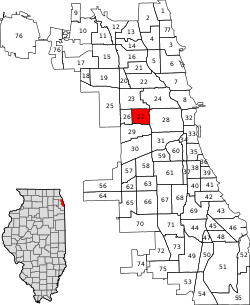 Location within the city of Chicago | |
| Coordinates: 41°52.8′N 87°42′W | |
| Country | United States |
| State | Illinois |
| County | Cook |
| City | Chicago |
| Neighborhoods | |
| Area | |
| • Total | 1.94 sq mi (5.02 km2) |
| Population (2020) | |
| • Total | 19,992[1] |
| Demographics 2015[1] | |
| • White | 4.25% |
| • Black | 91.28% |
| • Hispanic | 3.52% |
| • Asian | 0.28% |
| • Other | 0.68% |
| Time zone | UTC-6 (CST) |
| • Summer (DST) | UTC-5 (CDT) |
| ZIP Codes | parts of 60612 and 60624 |
| Median household income | $21,482[1] |
| Source: U.S. Census, Record Information Services | |
Taking its name from the large urban park, Garfield Park, the neighborhood is bordered by Franklin Boulevard on the north, Arthington and Taylor Streets on the south, Hamlin Avenue and Independence Boulevard to the west, and Rockwell Street to the east.
Demographics
| Historical population | ||||||||||
|---|---|---|---|---|---|---|---|---|---|---|
| Year | 1930 | 1940 | 1950 | 1960 | 1970 | 1980 | 1990 | 2000 | 2010 | 2020 |
| Pop. | 63,353 | 65,789 | 70,091 | 66,871 | 52,005 | 31,580 | 24,030 | 20,881 | 20,567 | 19,992 |
| ±% | — | +3.8% | +6.5% | −4.6% | −22.2% | −39.3% | −23.9% | −13.1% | −1.5% | −2.8% |
| "Chicago Community Area Historical Data".[1] | ||||||||||
Crime
East Garfield Park has long-standing issues with violent crime and property crime; in 2014, it was ranked 6th out of 77 Community areas in Chicago in violent crime and 10th among Chicago community areas in property crimes.[2]
Arts and culture
Nearly 20% of the neighborhood is managed by the Chicago Park District, with Garfield Park occupying the northwest corner of the neighborhood. The neighborhood is home to the Garfield Park Conservatory, one of the largest conservatories in the United States.
Government
The East Garfield Park community area has supported the Democratic Party in the past two presidential elections by overwhelming margins. In the 2016 presidential election, the East Garfield Park cast 6,690 votes for Hillary Clinton and cast 141 votes for Donald Trump (96.22% to 2.03%).[3] In the 2012 presidential election, East Garfield Park cast 9,046 votes for Barack Obama and cast 100 votes for Mitt Romney (98.51% to 1.09%).[4]
Education
Chicago Public Schools operates district public schools.
In addition Urban Prep Academies operates the East Garfield Park Campus.[5] Providence St. Mel School, a private school, is in East Garfield Park.[6]
Infrastructure
Transportation
Two of Chicago Transit Authority's train lines, the Blue Line and the Green Line, serves this neighborhood. The Green Line has stations at California, Kedzie, and Central Park Drive. The Blue Line has a station in the neighborhood in the median of the Eisenhower Expressway, Kedzie-Homan.
The neighborhood is also served by the CTA's bus service. East-west bus routes include 20 along Madison Street, 126 along Jackson Street, and 7 along Harrison Street. North-south bus routes include 94 along California Avenue, 52 along Kedzie Avenue, and 82 along Homan Avenue.
Notable people
- Lupe Fiasco (born 1982), Grammy Award-winning rapper & producer [7]
- Alfonzo McKinnie (born 1992), professional basketball player, currently active for the Chicago Bulls
- Louis J. Sebille (1915–1950), pilot in the United States Army Air Forces and recipient of the Medal of Honor. He resided at 2840 West Washington Street.[8]
- Isiah Thomas (born 1961), former professional basketball player and hall of famer, coach and sports analyst. He was a childhood resident of East Garfield Park living at 3340 West Congress Parkway.[9]
See also
 Chicago portal
 Illinois portal
References
- "Community Data Snapshot - East Garfield Park" (PDF). cmap.illinois.gov. MetroPulse. Retrieved November 29, 2017.
- "Crime in Chicagoland - East Garfield Park". chicagotribune.com.
- Ali, Tanveer (November 9, 2016). "How Every Chicago Neighborhood Voted In The 2016 Presidential Election". DNAInfo. Archived from the original on September 24, 2019. Retrieved October 4, 2019.
- Ali, Tanveer (November 9, 2012). "How Every Chicago Neighborhood Voted In The 2012 Presidential Election". DNAInfo. Archived from the original on February 3, 2019. Retrieved October 4, 2019.
- "East Garfield Park." Urban Prep Academies. Retrieved on December 10, 2010.
- "Contact Archived 2012-11-01 at the Wayback Machine." Providence St. Mel School. Retrieved on April 16, 2011. "Providence St. Mel 119 South Central Park Avenue Chicago, Illinois 60624"
- url=https://wnur.org/lupe-fiasco-at-the-riviera/
- Thompson, John (May 7, 1944). "'D' DAY WILL FIND CHICAGO FLYERS ON GUARD IN AIR: They'll Be Blasting Foe from Their Marauders". Chicago Daily Tribune.
- Thomas, Isiah (May 26, 2019). "Pop A Cork With Isiah Thomas!". N'Digo (Interview). Interviewed by Hermene Hartman. Chicago: Hartman Publishing. Retrieved November 25, 2020.
External links
Places adjacent to East Garfield Park, Chicago | ||||||||||||||||
|---|---|---|---|---|---|---|---|---|---|---|---|---|---|---|---|---|
| ||||||||||||||||
| |
|
Authority control | |
|---|---|
| General |
|
| National libraries | |
Другой контент может иметь иную лицензию. Перед использованием материалов сайта WikiSort.org внимательно изучите правила лицензирования конкретных элементов наполнения сайта.
WikiSort.org - проект по пересортировке и дополнению контента Википедии