world.wikisort.org - USA
Duncan is an unincorporated community in Casey County, Kentucky, United States. Duncan is located at the junction of Kentucky Route 501 and Kentucky Route 837 12 miles (19 km) east-northeast of Liberty.[2]
Duncan, Kentucky | |
|---|---|
Unincorporated community | |
 Duncan, Kentucky | |
| Coordinates: 37°21′31″N 84°43′39″W | |
| Country | United States |
| State | Kentucky |
| County | Casey |
| Elevation | 1,329 ft (405 m) |
| Time zone | UTC-5 (Eastern (EST)) |
| • Summer (DST) | UTC-4 (EDT) |
| Area code(s) | 606 |
| GNIS feature ID | 507889[1] |
References
- "Duncan". Geographic Names Information System. United States Geological Survey.
- State Primary Road System: Casey County (PDF) (Map). Kentucky Transportation Cabinet. 2011. Retrieved June 11, 2012.
Municipalities and communities of Casey County, Kentucky, United States | ||
|---|---|---|
County seat: Liberty | ||
| City | 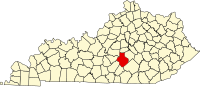 | |
| Unincorporated Communities | ||
| Ghost Towns | ||
| ||
This Casey County, Kentucky state location article is a stub. You can help Wikipedia by expanding it. |
Текст в блоке "Читать" взят с сайта "Википедия" и доступен по лицензии Creative Commons Attribution-ShareAlike; в отдельных случаях могут действовать дополнительные условия.
Другой контент может иметь иную лицензию. Перед использованием материалов сайта WikiSort.org внимательно изучите правила лицензирования конкретных элементов наполнения сайта.
Другой контент может иметь иную лицензию. Перед использованием материалов сайта WikiSort.org внимательно изучите правила лицензирования конкретных элементов наполнения сайта.
2019-2026
WikiSort.org - проект по пересортировке и дополнению контента Википедии
WikiSort.org - проект по пересортировке и дополнению контента Википедии