world.wikisort.org - USA
Downtown Indianapolis is a neighborhood area and the central business district of Indianapolis, Indiana, United States. Downtown is bordered by Interstate 65, Interstate 70, and the White River, and is situated near the geographic center of Marion County. Downtown has grown from the original 1821 town plat—often referred to as the Mile Square—to encompass a broader geographic area of central Indianapolis, containing several smaller historic neighborhoods.
Downtown Indianapolis | |
|---|---|
Neighborhood Area of Indianapolis | |
 Downtown Indianapolis in 2016 | |
| Nickname: "Downtown Indy" | |
 Location of Downtown within Indianapolis–Marion County, Indiana | |
| Coordinates: 39.77°N 86.16°W | |
| Country | |
| State | |
| County | Marion |
| Township | Center |
| City | |
| Population (2020)[1] | |
| • Total | 22,412 |
| Time zone | UTC−5 (EST) |
| • Summer (DST) | UTC−4 (EDT) |
| ZIP code | 46202, 46203, 46204, 46225 |
| Area code | 317 / 463 |
| Website | www |
Downtown Indianapolis is the cultural, political, and economic center of the Indianapolis metropolitan area. Downtown Indianapolis anchors the city's burgeoning tourism and hospitality sector, home to nearly 8,000 hotel rooms and several of the city's major sporting and event facilities. Downtown contains numerous historic districts and properties, most of the city's memorials and monuments, performing arts venues, and museums. Since its founding in 1820, the seats of Indianapolis's local administration and Indiana's state government have been located Downtown. Downtown Indianapolis is also home to the highest density of commercial office space and employment in the state of Indiana.
Location and boundaries

When Indianapolis was founded in 1820, the new capital city was planned to occupy an area of 1-square-mile (2.6 km2) adjacent to the White River and near the geographic center of Marion County. The plat included eastern and western "anchors": the Indiana Statehouse (west) and the Indianapolis City Market and Marion County Courthouse (east), respectively. As the population increased and the city matured, the original plat continued to densify, developing into the region's central business district.
The city's historical core and present-day central business district is sometimes referred to as the "Mile Square". However, the Downtown "neighborhood area" defines a broader geography, incorporating an area bounded by 16th Street and Interstate 65 (north), Interstate 65/70 (east), Interstate 70 (south), and the White River (west). Downtown is generally bisected into four quadrants, divided by Meridian Street (north to south) and Washington Street (east to west).(about 7 square miles)
Downtown Indianapolis is sited on flat terrain near the confluence of the White River and Fall Creek. Pogue's Run, a smaller tributary of the White River, flows beneath Downtown. The waterway was channeled into a sanitary tunnel in 1914.[2]
Neighborhoods and districts
Downtown Indianapolis contains 36 apartment buildings that are listed on the National Register of Historic Places in the Apartments and Flats of Downtown Indianapolis Thematic Resources.[3] Entries in italics denote designated cultural districts.
- Canal and White River State Park
- Chatham–Arch
- Cole-Noble District
- Flanner House Homes
- Fletcher Place
- Holy Rosary–Danish Church Historic District
- Indiana Avenue
- Indiana World War Memorial Historic District
- Lockefield Gardens
- Lockerbie Square Historic District
- Market East
- Mass Ave
- Old Southside Historic District
- Ransom Place Historic District
- St. Joseph Neighborhood Historic District
- Washington Street–Monument Circle Historic District
- Wholesale District
History
19th century


Downtown Indianapolis dates to the city's founding as the state of Indiana's new capital in 1820 near the east bank of the White River. The state legislature appointed Alexander Ralston and Elias Pym Fordham to survey and design a town plan for Indianapolis, which was platted in 1821.[4] Ralston's original plan for Indianapolis called for a town of 1-square-mile (2.6 km2) bounded by North, East, South, and West streets (although they were not named at that time), with Governor's Circle, a large circular commons, at the center of town.
Ralston's grid pattern with wide roads and public squares extended outward from the four blocks adjacent to the Circle, and also included four diagonal streets, later renamed as avenues.[5] Public squares were reserved for government and community use, but not all of these squares were used for this intended purpose.[6] Ralston altered the grid pattern in the southeast quadrant to accommodate the flow of Pogue's Run, but a plat created in 1831 changed his original design and established a standard grid there as well.[7]
Ralston's basic street plan is still evident in present-day Downtown Indianapolis.[8] Streets in the original plat were named after states that were part of the United States when Indianapolis was initially planned, with the addition of Michigan, which was a U.S. territory at that time. Tennessee and Mississippi Streets were renamed Capitol and Senate Avenues in 1895 after several state government buildings were built west of the Circle near the Indiana Statehouse. There are a few other exceptions to the early street names. The National Road, which eventually bisected Indiana, passes through Indianapolis along Washington Street, a 120-foot-wide (37 m) east-west street (more recently converted into a one-way westbound street west of New Jersey Street) located one block south of the Circle. The city's address numbering system begins at the intersection of Washington and Meridian streets.[9] Meridian and Market Streets intersect the Circle. Few street improvements were made in the 1820s and 1830s; sidewalks did not appear until 1839 or 1840.[10]
In the last half of the nineteenth century, when the city's population soared from 8,091 in 1850 to 169,164 in 1900, urban development expanded in all directions as Indianapolis experienced a building boom and transitioned from an agricultural community to an industrial center.[11] Some of the city's most iconic structures were built during this period, including several that have survived to the present day in Downtown: the Soldiers' and Sailors' Monument (1888, dedicated 1902), the Indiana Statehouse (1888), Union Station (1888), and the Das Deutsche Haus (1898), among others.[12]
20th century
Following World War II, expansion of the American middle class, suburbanization, and declining manufacturing employment greatly impacted Downtown Indianapolis, similar to most U.S. central business districts at this time. Urban renewal projects of this era hastened the central business district's decline, particularly the clearance of working-class neighborhoods. The neighborhoods surrounding Indiana Avenue, the center of the city's African American community, were particularly impacted. The establishment of the Indiana University – Purdue University Indianapolis (IUPUI) campus in 1969 and the construction of Interstate 65 and Interstate 70 in the 1960s and 1970s resulted in large-scale displacement of African Americans.


The loss of population and activity Downtown prompted civic leaders to plan for economic development and revitalization of the area. Among the first projects was the opening of Market Square Arena, which served as home to the Indiana Pacers and host to numerous concerts and other sporting events. The success of Market Square Arena helped persuade decision-makers to make Downtown the center of an aggressive sports tourism strategy. Throughout the 1980s, $122 million in public and private funding built several athletic facilities Downtown, including the Indianapolis Tennis Center, Indiana University Natatorium, Carroll Track and Soccer Stadium, and the Hoosier Dome. The latter project helped secure the 1984 relocation of the Baltimore Colts, the 1987 Pan American Games, and scores of subsequent athletic events of national and international interest.[13]
Modern skyscraper construction catapulted Downtown office and commercial space in the 1980s. A building boom, lasting from 1982 to 1990, saw the construction of six of the city's ten tallest buildings.[14][15] These included OneAmerica Tower (1982), Fifth Third Bank Tower (1983), Capital Center South Tower (1987), BMO Plaza (1988), Market Tower (1988), 300 North Meridian (1989), and the tallest, Salesforce Tower (1990).[16]
The non-profit Downtown Indy, Inc. was established in 1993 to help promote economic development, beautification, and program events. Reinvestment continued through the 1990s, with the continued buildout of White River State Park museums and attractions, development of the Canal Walk, Circle Centre Mall (1995), Victory Field (1996), and Gainbridge Fieldhouse (1999).
21st century

The city's successful sports tourism campaign provided local leadership with a template for increasing Downtown's capacity to host conventions and trade shows. Two of the city's tallest buildings to be completed in the 21st century, Conrad Indianapolis (2006) and the JW Marriott Indianapolis (2011), are hotels. Following the opening of Lucas Oil Stadium in 2008, the Indiana Convention Center completed its largest expansion in 2011.
In the 2010s, Downtown experienced increased demand for housing. Numerous mixed-use and apartment buildings were developed during this time. According to Downtown Indy, Inc., the number of apartment units Downtown has increased 61 percent from 2011 to 2015, with more than 50 percent of new development occurring inside the Mile Square.[17] In 2010, the population of Downtown was 14,664; by 2020, the population had increased to 22,412.
Economy
Downtown is the densest employment cluster in the state of Indiana.[18] According to Downtown Indy, Inc., in 2021, there were about 154,500 workers.[lower-alpha 1] According to Colliers International, the central business district commercial office market contained 11.8 million square feet (1,100,000 m2) of office space, with a direct vacancy rate of 16.9 percent in 2017.[19] Downtown Indianapolis is home to two of the city's three Fortune 500 companies: health insurance company Elevance Health and pharmaceutical company Eli Lilly and Company.[20] Other prominent companies based Downtown include: Cummins Global Distribution Headquarters;[21] media conglomerate Emmis Communications; financial services holding company OneAmerica; the National Collegiate Athletic Association (NCAA); local newspaper The Indianapolis Star; and fast food restaurant chain Steak 'n Shake.
Tourism

The hospitality industry is an increasingly vital sector to the Indianapolis economy, especially Downtown. According to Visit Indy, 28.2 million visitors generated $4.9 billion in 2015, the fourth straight year of record growth.[22] Indianapolis has long been a sport tourism destination, but has more recently relied on conventions.[23] The Indiana Convention Center (ICC) and Lucas Oil Stadium are considered mega convention center facilities, with a combined 750,000 square feet (70,000 m2) of exhibition space.[24] ICC is connected to 12 hotels and 4,700 hotel rooms, the most of any U.S. convention center.[25] In 2008, the facility hosted 42 national conventions with an attendance of 317,815; in 2014, it hosted 106 for an attendance of 635,701.[23]
According to Downtown Indy, Inc., there are 34 hotels with a total of 7,839 hotel rooms.[26] Most hotels are clustered in the blocks immediately adjacent to the Indiana Convention Center in Downtown's southeast quadrant. Notable hotels include:
- The Columbia Club
- Conrad Indianapolis
- Hilton Garden Inn Indianapolis Downtown
- Hilton Indianapolis
- Hyatt Regency Indianapolis
- Indianapolis Marriott Downtown
- JW Marriott Indianapolis
- Le Méridien Indianapolis Hotel
- Omni Severin Hotel
Attractions
Recent developments in downtown Indianapolis include the construction of new mid- to high-rise buildings and the $275 million expansion of the Indiana Convention Center completed in 2011.[27][28] After 12 years of planning and six years of construction, the Indianapolis Cultural Trail: A Legacy of Gene & Marilyn Glick officially opened in 2013.[29] The $62.5 million public-private partnership resulted in 8 miles (13 km) of urban bike and pedestrian corridors linking six cultural districts with neighborhoods, IUPUI, and every significant arts, cultural, heritage, sports and entertainment venue downtown.[30][31][32][33] A 2015 Indiana University Policy Institute report found assessed property values along the Cultural Trail increased by over $1 billion from 2008 to 2014.[34]
Bars and restaurants
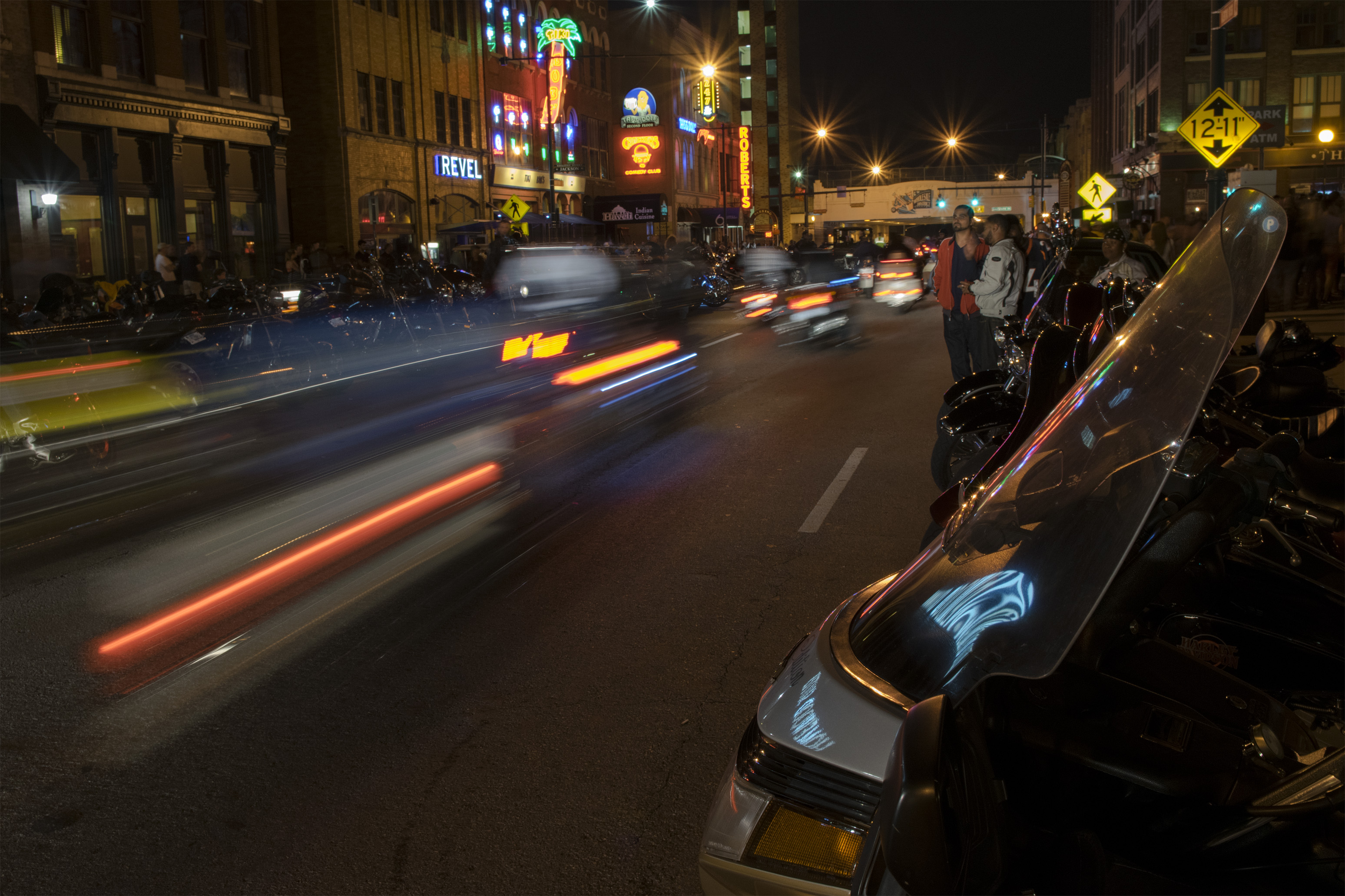
Downtown's main nightlife areas are located on Meridian Street near Georgia Street and along Massachusetts Avenue. A variety of nightclubs, live music venues, bars, and restaurants are clustered along South Meridian and Georgia streets between Monument Circle and Lucas Oil Stadium. Massachusetts Avenue, or Mass Ave, lies northeast of the central business district and is lined with high-end local bars and restaurants. Easley Winery and Sun King Brewery are located on College Avenue on the east side of Downtown.
Some of the nightclubs and bars in the Wholesale District include Slippery Noodle Inn, Howl at the Moon, Tiki Bob's, Claddagh Irish Pub, Kilroy's Bar and Grill, St. Elmo Steak House, and a cigar lounge called Nicky Blaines.[35] Mass Ave bars include The Eagle, Burnside Inn, Bazbeaux Pizza, Tavern on the Point, Chatterbox, Mesh on Mass, FortyFive Degrees, and Metro. Mass Ave also has various European bars that include MacNiven's (Scottish), Chatham Tap (English), and The Rathskeller (German).[36]
Entertainment
Athletics
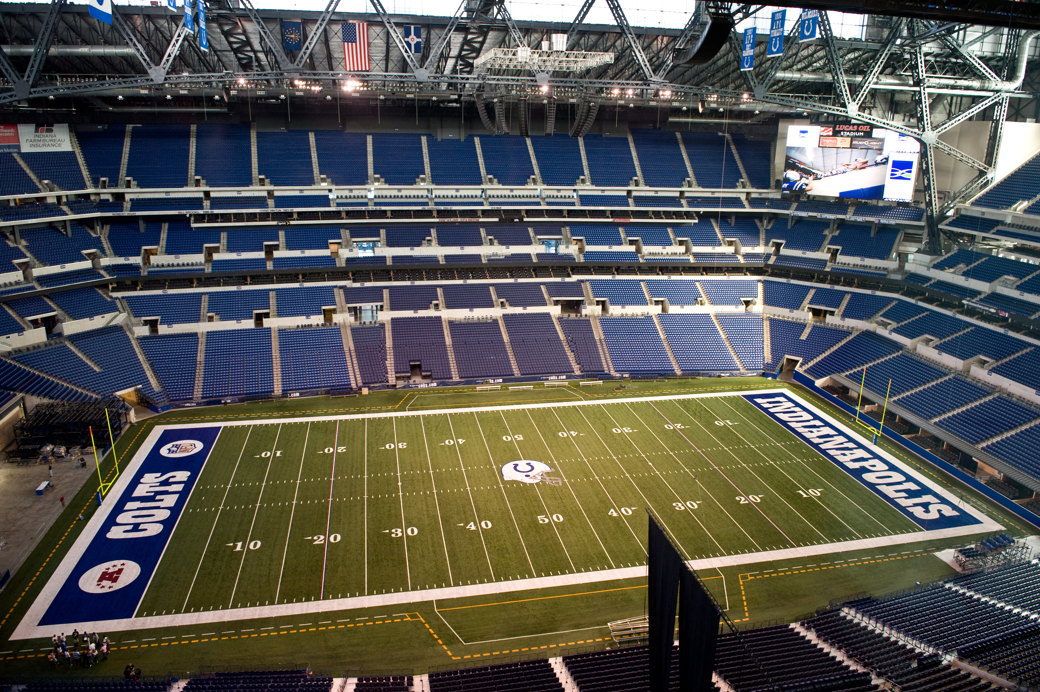
The city's professional sports clubs and major athletic venues are located south of Washington Street, including Gainbridge Fieldhouse (home to the Indiana Fever and Pacers), Lucas Oil Stadium (home to the Indianapolis Colts), and Victory Field (home to the Indianapolis Indians). The remaining sports facilities are located in the northwestern section of Downtown on the campus of IUPUI.
- Gainbridge Fieldhouse
- Indiana Pacers
- Indiana Fever
- Indiana University Natatorium
- Indianapolis Colts
- Indianapolis Indians
- IU Michael A. Carroll Track & Soccer Stadium
- IUPUI Jaguars
- Indy Eleven
- Lucas Oil Stadium
- Victory Field
Music and theater
- Athenæum (Das Deutsche Haus)
- The Cabaret
- The District Theatre
- Hilbert Circle Theatre
- Indiana Theatre
- Indiana Repertory Theatre
- Indianapolis Artsgarden
- Indianapolis Symphony Orchestra
- IndyFringe Basile and Indy Eleven Theatres
- Madam Walker Legacy Center
- Old National Centre
- The Pavilion at Pan Am
- Phoenix Theatre
- TCU Amphitheater at White River State Park
Monuments and memorials

- Indiana 9/11 Memorial
- Indiana Law Enforcement and Firefighters Memorial
- Indiana World War Memorial Plaza
- Medal of Honor Memorial
- Peirce Geodetic Monument
- Soldiers' and Sailors' Monument
- USS Indianapolis National Memorial
- Wooden's Legacy
Note: For an overview and complete list of all memorials and monuments on the grounds of Indiana Government Center, see Indiana Statehouse Public Art Collection.
Museums
- Colonel Eli Lilly Civil War Museum
- Crispus Attucks High School and Museum
- Eiteljorg Museum of American Indians and Western Art
- Emil A. Blackmore Museum of The American Legion
- Indiana Historical Society
- Indiana State Library and Historical Bureau
- Indiana State Museum
- Indiana World War Memorial Military Museum
- Indianapolis Firefighters Museum
- James Whitcomb Riley Museum Home
- Kurt Vonnegut Museum and Library
- Masonic Library and Museum of Indiana
- NCAA Hall of Champions
- Rhythm! Discovery Center
Other
- Central Library
- Circle Centre Mall
- Indiana Convention Center
- Indianapolis Catacombs
- Indianapolis City Market
- Scottish Rite Cathedral
Parks, plazas, and squares

In 2021, Downtown Indianapolis contained about 340 acres (140 ha) across 28 parks and public spaces.[lower-alpha 1] The Indiana World War Memorial Plaza encompasses three distinct downtown greenspaces: American Legion Mall, Veterans Memorial Plaza, and University Park. The Indianapolis Canal Walk also includes three pocket parks: Community Service Plaza, Vermont Street Plazas, and Walnut Street Commons. Bicentennial Unity Plaza, the newest public space Downtown, is anticipated to open by the end of 2022.[38]
Note: Entries in italics denote privately-owned parks and plazas or those not under the management of the State of Indiana or the City of Indianapolis.
- Babe Denny Park
- Ball Nurses' Sunken Garden and Convalescent Park
- Bicentennial Plaza[39]
- Bicentennial Unity Plaza[38]
- Bill Gray Plaza
- Charles L. Whistler Memorial Plaza
- Chatham Commons
- Cummins Central Plaza
- Edna Balz Lacy Family Park
- Fallen Firefighters Memorial Plaza
- Hudnut Commons[40]
- Indianapolis Cultural Trail: A Legacy of Gene & Marilyn Glick
- Lt. Jr. Gr. Graham Edward Martin Park
- Matthew R. Gutwein Commonground at Eskenazi Health
- Merrill Street Pocket Park
- Military Park
- Monument Circle
- Pan American Plaza
- Pathways to Peace Garden
- Presidential Place Park
- Ransom Place Neighborhood Park
- Richard G. Lugar Plaza
- South Street Square Park
- White River Greenway
- White River State Park
Public art
Government


As the state capital, Indianapolis is the seat of Indiana's state government. The city has hosted the capital since its move from Corydon in 1825. The Indiana Statehouse, located Downtown, houses the executive, legislative, and judicial branches of state government, including the offices of the Governor and Lieutenant Governor of Indiana, the Indiana General Assembly, and the Indiana Supreme Court. Most state departments and agencies are located in Indiana Government Centers North and South.
The consolidated city-county government of Indianapolis and Marion County (known as Unigov) is also located Downtown at the City-County Building. The City-County Building houses the executive, legislative, and judicial branches of local government, as well as municipal departments, and the Indianapolis Metropolitan Police Department.
Federal field offices are located in the Birch Bayh Federal Building and United States Courthouse (which houses the United States District Court for the Southern District of Indiana) and the Minton-Capehart Federal Building, both located Downtown.
Infrastructure
Education

Downtown is home to Indiana University – Purdue University Indianapolis (IUPUI), the third largest campus in the state based on enrollment, with 30,105 students.[41] IUPUI contains two colleges and 18 schools, including the Herron School of Art and Design, Robert H. McKinney School of Law, School of Dentistry, and the Indiana University School of Medicine, the largest medical school in the U.S.[42][43]
Indianapolis Public Schools (IPS) is headquartered Downtown in the John Morton-Finney Educational Service Center. As of 2016[update], IPS was the second largest public school district in Indiana, serving nearly 30,000 students.[44][45]
Located Downtown, the Indianapolis Public Library's Central Library is the hub of the public library's 23 branch system, which served 4.2 million patrons and a circulation of 15.9 million materials in 2014.[46]
Healthcare
Downtown's northwest quadrant is home to the largest cluster of healthcare facilities in the region. Located on the IUPUI campus, the Indiana University Health Medical Center encompasses the Indiana University School of Medicine, University Hospital, and Riley Hospital for Children. This area is roughly bounded by 10th Street (north), Michigan Street (south), University Boulevard (east), and Riley Hospital Drive (west). Indiana University Health Methodist Hospital, the largest facility in the state, is located on 16th Street, immediately outside Downtown in the Near Northside neighborhood area. The city's primary public medical centers, Sidney & Lois Eskenazi Hospital and the Richard L. Roudebush VA Medical Center, are situated immediately west of the Indiana University Medical Center in an area bounded by 10th Street (north), Michigan Street (south), Eskenazi Avenue (east), and Porto Alegre Street (west).
Transportation

Downtown Indianapolis has been the regional transportation hub for central Indiana since its establishment. The first major federally funded highway in the U.S., the National Road (now Washington Street), reached Indianapolis in 1836,[47] followed by the railroad in 1847. Indianapolis Union Station opened in 1853 as the world's first union station.[48] Citizen's Street and Railway Company was established in 1864, operating the city's first mule-drawn streetcar line.[49][50] Opened in 1904 on West Market Street, the Indianapolis Traction Terminal was the largest interurban station in the world, handling 500 trains daily and 7 million passengers annually.[51] Ultimately doomed by the automobile, the terminal closed in 1941, followed by the streetcar system in 1957.[52]
Two of the region's four interstate highways (Interstate 65 and Interstate 70) form an "inner loop" on the north, east, and south sides of downtown Indianapolis. I-65 and I-70 radiate from downtown to connect with the "outer loop," a beltway called Interstate 465.
IndyGo operates the city's public transit network, with downtown Indianapolis serving as the region's hub and spoke origin. In 2016, the Julia M. Carson Transit Center opened as the downtown hub for 27 of its 31 bus routes.[53] The Central Indiana Regional Transportation Authority (CIRTA) is a quasi-governmental agency that operates three public buses from the Julia M. Carson Transit Center to employment centers in Plainfield and Whitestown.
Downtown Indianapolis continues to be the city's intercity transportation hub. Amtrak provides intercity rail service via the Cardinal, which makes three weekly trips between New York City and Chicago. Union Station served about 30,000 passengers in 2015.[54] Three intercity bus service providers stop in the city: Greyhound Lines and Burlington Trailways (via Union Station), and Megabus (via City Market).[55]
The Indianapolis Airport Authority operates the Indianapolis Downtown Heliport, which opened for public use in 1979.
Utilities
AES Indiana, the city's electricity provider, is headquartered on Monument Circle. Citizens Energy Group's Perry K. Generating Station burns natural gas to produce steam to provide heat and hot water to 200 customers in Downtown's district heating system.
See also
- List of tallest buildings in Indianapolis
Notes
- Stats and figures are available by accessing Downtown Indy, Inc.'s 2021 Community Report.[37]
References
- "Downtown Neighborhood Area" (website). Indy Vitals and The Polis Center at IUPUI. 2016. Retrieved April 8, 2022.
- Higgins, Will (May 19, 2015). "Urban trekkers seek to uncover mystery of Pogue's Run". The Indianapolis Star. Gannett Company. Retrieved April 9, 2021.
- "National Register Information System". National Register of Historic Places. National Park Service. March 13, 2009.
- Hyman, p. 10, and William A. Browne Jr. (Summer 2013). "The Ralston Plan: Naming the Streets of Indianapolis". Traces of Indiana and Midwestern History. Indianapolis: Indiana Historical Society. 25 (3): 8–9.
- Massachusetts Street points diagonally to the northeast, Virginia Street to the southeast, Kentucky Street to the southwest, and Indiana Street to the northwest, beyond the Circle. See Browne, pp. 11, 16.
- A revised town plat from 1831 indicated public squares were set aside for a state university (square 25) and a state hospital (square 22). See Hale, p. 10, and Hyman, p. 10.
- Hale, p. 79.
- Indianapolis, A Walk Through Time: A Self-Guided Tour of Historic Sites in the Mile Square Area. Indianapolis: Marion County-Indianapolis Historical Society. 1996. p. 3.
- Bodenhamer, David; Barrows, Robert, eds. (1994). The Encyclopedia of Indianapolis. Bloomington & Indianapolis: Indiana University Press. p. 1485.
- Brown, p. 25, and Browne, pp. 9–10, 17.
- Bodenhamer and Barrows, eds., pp. 1481, 1486; Brown, p. 16; and Hester Ann Hale (1987). Indianapolis: The First Century. Indianapolis, IN: Marion County/Indianapolis Historical Society. p. 40. OCLC 16227635.
- Major structures constructed during this era that have been demolished include Tomlinson Hall (1883–86), a civic auditorium at Delaware and Market Street, and English's Opera House and Hotel (1880; 1884, 1896) on Monument Circle, among others. See Bodenhamer and Barrows, eds., pp. 546–47; 1336–37.
- Ted Greene and Jon Sweeney (January 20, 2012). Naptown to Super City (television broadcast). Indianapolis: WFYI-TV (PBS). Retrieved March 26, 2016.
- Bodenhamer, David; Barrows, Robert, eds. (1994). The Encyclopedia of Indianapolis. Bloomington & Indianapolis: Indiana University Press. pp. 28–37. ISBN 0-253-31222-1.
- "Tallest buildings in Indianapolis". Emporis.com. Archived from the original on April 8, 2015. Retrieved June 11, 2016.
- "Salesforce Tower, Indianapolis". Emporis.com. Archived from the original on August 6, 2016. Retrieved September 4, 2017.
- "2016 Downtown Living Guide". Downtown Indy, Inc. Retrieved May 5, 2019.
- Klacik, Drew (September 2013). "Why Downtown Indianapolis Matters" (PDF). Indiana University Public Policy Institute. Archived from the original (PDF) on September 3, 2017. Retrieved July 21, 2017.
- Winkler, James (2017). "CBD Vacancy Rate Falls to Eight-Year Low" (PDF). Colliers International. Retrieved November 4, 2017.
- "Fortune 500 Companies in Indiana". Fortune. Retrieved August 1, 2016.
- Orr, Susan (January 5, 2017). "Cummins unveils downtown Indy office complex, recruiting tool". Indianapolis Business Journal. Retrieved January 23, 2017.
- Bartner, Amy (January 24, 2017). "Visit Indy touts 4th year of record tourism". The Indianapolis Star. Retrieved January 31, 2017.
- Schoettle, Anthony (September 25, 2015). "Expand the Indiana Convention Center again?". Indianapolis Business Journal. Retrieved June 30, 2016.
- "350 Big Changes at Nation's Biggest Convention Centers" (PDF). Trade Show Executive. Retrieved July 29, 2016.
- "Connected Hotels in Indianapolis". Visit Indy. Retrieved March 31, 2016.
- Shuey, Mickey (April 16, 2020). "Downtown hotel occupancy fell 91% as health crisis escalated". Indianapolis Business Journal. IBJ Media. Retrieved April 20, 2020.
- "Downtown Indy". DowntownIndy. Archived from the original on 8 February 2009. Retrieved 20 December 2014.
- Sikich, Chris (April 19, 2014). "Convention City: Convention Center's growth vaults Indy to upper tier". The Indianapolis Star. Retrieved February 11, 2017.
- Simmons, Andrew (March 4, 2014). "In Indianapolis, a Bike Path to Progress". The New York Times. ISSN 0362-4331. Retrieved January 14, 2016.
- "Trail Facts". Indianapolis Cultural Trail Inc. Retrieved March 25, 2016.
- Foxio (June 16, 2013). "Indianapolis Cultural Trail". Indyculturaltrail.org. Retrieved January 14, 2014.
- "Project for Public Spaces". pps.org. May 10, 2013. Retrieved January 14, 2014.
- "The new Indianapolis Cultural Trail is a masterpiece of bike-friendly design Cleveland should emulate". cleveland.com. Retrieved 2017-05-03.
- Burow, Sue; Majors, Jessica (March 2015). "Assessment of the Impact of the Indianapolis Cultural Trail: A Legacy of Gene and Marilyn Glick" (PDF). Archived from the original (PDF) on September 8, 2015. Retrieved March 25, 2016.
{{cite journal}}: Cite journal requires|journal=(help) - "Indianapolis - DOWNTOWN Night Club List". Indymotorspeedway.com. Retrieved 20 December 2014.
- "Bars and Clubs in Downtown". Archived from the original on August 22, 2011. Retrieved August 24, 2011.
- "Downtown Indy, Inc. 2021 Community Report". Downtown Indy, Inc. April 28, 2021. p. 4. Retrieved April 10, 2022.
- Lindquist, Dave (March 4, 2022). "Two major public art installations announced for Gainbridge Fieldhouse plaza". Indianapolis Business Journal. IBJ Media. Retrieved April 10, 2022.
- "Bicentennial Plaza". State of Indiana. Retrieved April 10, 2022.
- Schouten, Cory (November 13, 2014). "Hudnut statue to honor 'people's mayor'". Indianapolis Business Journal. IBJ Media. Retrieved April 10, 2022.
- "Rankings & Campus Statistics". IUPUI. Retrieved May 17, 2016.
- "Schools: Academics: Indiana University–Purdue University Indianapolis". IUPUI. Retrieved May 17, 2016.
- "Facts & Figures". IU Health. Retrieved February 6, 2016.
- "Unigov Handbook: A Citizen's Guide to Local Government" (PDF). League of Women Voters of Indianapolis. Retrieved November 3, 2017.
- "Indianapolis Public Schools (5385)". Indiana Department of Education. Retrieved May 17, 2016.
- "Library at a Glance". Indianapolis Public Library. Archived from the original on January 9, 2016. Retrieved January 16, 2016.
- Baer, p. 11, and Hyman, p. 34.
- "Indianapolis Union Railroad Station". Discover Our Shared Heritage Travel Itinerary. Washington, D.C.: National Park Service. Retrieved November 3, 2017.
- Brown, p. 50.
- Sulgrove, pp. 134, 424–26.
- "Transportation in Indianapolis: then and now". Indianapolis Public Transportation Corporation. Archived from the original on August 26, 2014. Retrieved August 28, 2014.
- O'Malley, Chris (August 27, 2011). "Backer seek support for 2-mile streetcar line downtown". Indianapolis Business Journal. Retrieved February 7, 2016.
- Tuohy, John (June 27, 2016). "IndyGo transit center passes rush-hour test". The Indianapolis Star. Retrieved July 1, 2016.
- "Amtrak Fact Sheet, Fiscal Year 2016, State of Indiana" (PDF). Amtrak. Retrieved November 3, 2017.
- "Bus From Chicago to Indianapolis & Indianapolis to Chicago". Megabus. Archived from the original on April 12, 2016. Retrieved April 1, 2016.
External links
Другой контент может иметь иную лицензию. Перед использованием материалов сайта WikiSort.org внимательно изучите правила лицензирования конкретных элементов наполнения сайта.
WikiSort.org - проект по пересортировке и дополнению контента Википедии