world.wikisort.org - USA
Deerwood is an unincorporated community and census-designated place (CDP) in Montgomery County, Texas, United States. It was first listed as a CDP prior to the 2020 census.[2]
Deerwood, Texas | |
|---|---|
Census-designated place | |
 Deerwood  Deerwood | |
| Coordinates: 30°18′56″N 95°18′3″W | |
| Country | United States |
| State | Texas |
| County | Montgomery |
| Area | |
| • Total | 0.57 sq mi (1.48 km2) |
| • Land | 0.57 sq mi (1.48 km2) |
| • Water | 0.0 sq mi (0.0 km2) |
| Elevation | 188 ft (57 m) |
| Time zone | UTC-6 (Central (CST)) |
| • Summer (DST) | UTC-5 (CDT) |
| ZIP Code | 77306 (Conroe) |
| Area code | 936 |
| FIPS code | 48-19632 |
| GNIS feature ID | 2805821[2] |
It is in the eastern part of the county, 10 miles (16 km) east of Conroe, the county seat, and 2 miles (3 km) southeast of Texas State Highway 105. It is within the southwest corner of Sam Houston National Forest, and it is bordered to the south by Conroe Division of the BNSF Railway.
References
- "2020 U.S. Gazetteer Files – Texas". United States Census Bureau. Retrieved September 30, 2021.
- "Deerwood Census Designated Place". Geographic Names Information System. United States Geological Survey, United States Department of the Interior.
Municipalities and communities of Montgomery County, Texas, United States | ||
|---|---|---|
County seat: Conroe | ||
| Cities | 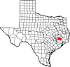 | |
| Towns | ||
| CDPs | ||
| Other communities | ||
| Ghost town | ||
| Footnotes | ‡This populated place also has portions in an adjacent county or counties | |
| ||
| This article about a location in Montgomery County, Texas is a stub. You can help Wikipedia by expanding it. |
Текст в блоке "Читать" взят с сайта "Википедия" и доступен по лицензии Creative Commons Attribution-ShareAlike; в отдельных случаях могут действовать дополнительные условия.
Другой контент может иметь иную лицензию. Перед использованием материалов сайта WikiSort.org внимательно изучите правила лицензирования конкретных элементов наполнения сайта.
Другой контент может иметь иную лицензию. Перед использованием материалов сайта WikiSort.org внимательно изучите правила лицензирования конкретных элементов наполнения сайта.
2019-2025
WikiSort.org - проект по пересортировке и дополнению контента Википедии
WikiSort.org - проект по пересортировке и дополнению контента Википедии