world.wikisort.org - USA
Canada is an unincorporated community in Pike County, Kentucky. Canada is located on U.S. Route 119, 13.8 miles (22.2 km) northeast of Pikeville.[2]
Canada, Kentucky | |
|---|---|
Unincorporated community | |
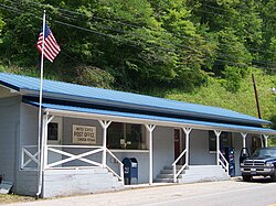
 Post office in Canada, Kentucky | |
 Canada, Kentucky | |
| Coordinates: 37°36′20″N 82°19′28″W | |
| Country | United States |
| State | Kentucky |
| County | Pike |
| Elevation | 833 ft (254 m) |
| Time zone | UTC-5 (Eastern (EST)) |
| • Summer (DST) | UTC-4 (EDT) |
| Area code | 606 |
| GNIS feature ID | 507642[1] |
There are two possible scenarios for the origin of the name "Canada". One possible explanation being that Canada (or “kanata”) is the Huron-Iroquois word for settlement, since the area once had a large population of Native Americans. The other explanation involves Zebulon Pike, a general in the War of 1812 who most of Pike County is named after. Pike died in Canada, which leads to this being a possible origin of the name "Canada".
References
- "Canada". Geographic Names Information System. United States Geological Survey, United States Department of the Interior.
- State Primary Road System: Pike County (PDF) (Map). Kentucky Transportation Cabinet. 2012. Retrieved September 20, 2012.
На других языках
[de] Canada (Kentucky)
Canada ist ein kleiner Ort im US-Bundesstaat Kentucky. Er liegt im Pike County, einer dünn besiedelten Region im äußersten Osten des Staates, in einer Höhe von 833 Fuß.- [en] Canada, Kentucky
Текст в блоке "Читать" взят с сайта "Википедия" и доступен по лицензии Creative Commons Attribution-ShareAlike; в отдельных случаях могут действовать дополнительные условия.
Другой контент может иметь иную лицензию. Перед использованием материалов сайта WikiSort.org внимательно изучите правила лицензирования конкретных элементов наполнения сайта.
Другой контент может иметь иную лицензию. Перед использованием материалов сайта WikiSort.org внимательно изучите правила лицензирования конкретных элементов наполнения сайта.
2019-2025
WikiSort.org - проект по пересортировке и дополнению контента Википедии
WikiSort.org - проект по пересортировке и дополнению контента Википедии
