world.wikisort.org - USA
Calumet is a neighborhood in northern Lexington, Kentucky, United States. Its boundaries are Viley Road to the west, Versailles Road to the south, New Circle Road to the north, and Wolf Run Creek to the east.[1]
Calumet | |
|---|---|
Neighborhood of Lexington, Kentucky | |
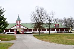 Stables at Calumet Farm | |
| Country | United States |
| State | Kentucky |
| County | Fayette |
| City | Lexington |
| Area | |
| • Total | 0.266 sq mi (0.69 km2) |
| Population (2000) | |
| • Total | 750 |
| • Density | 2,882/sq mi (1,087/km2) |
| Time zone | UTC-5 (Eastern (EST)) |
| • Summer (DST) | UTC-4 (EDT) |
| ZIP code | 40504 |
| Area code(s) | 859 |
Neighborhood statistics
- Area: 0.266 square miles (0.69 km2)
- Population: 750
- Population density: 2,822 people per square mile (1,087/km2)
- Median household income: $49,446[1]
References
- Calumet Neighborhood Profile city-data.com. Retrieved on 2011-01-02
Neighborhoods of Lexington-Fayette | ||
|---|---|---|
| Northeast |
|  |
| Northwest |
| |
| Southeast |
| |
| Southwest |
| |
| Footnotes | Fayette County and the City of Lexington are coextensive | |
| Subject areas |
|     |
|---|---|---|
| Culture and landmarks |
| |
| Colleges and universities |
| |
| Transportation |
| |
| Sports |
| |
| Metro Lexington | ||
This Fayette County, Kentucky state location article is a stub. You can help Wikipedia by expanding it. |
Текст в блоке "Читать" взят с сайта "Википедия" и доступен по лицензии Creative Commons Attribution-ShareAlike; в отдельных случаях могут действовать дополнительные условия.
Другой контент может иметь иную лицензию. Перед использованием материалов сайта WikiSort.org внимательно изучите правила лицензирования конкретных элементов наполнения сайта.
Другой контент может иметь иную лицензию. Перед использованием материалов сайта WikiSort.org внимательно изучите правила лицензирования конкретных элементов наполнения сайта.
2019-2026
WikiSort.org - проект по пересортировке и дополнению контента Википедии
WikiSort.org - проект по пересортировке и дополнению контента Википедии