world.wikisort.org - USA
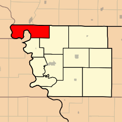
Buchanan Township is one of eleven townships in Atchison County, Missouri, United States. At the 2010 census, its population was 83.[3] The northwest corner of the township is the northwest corner of the entire state.
Buchanan Township | |
|---|---|
Township | |
 | |
| Coordinates: 40°32′26″N 095°37′16″W | |
| Country | |
| State | |
| County | Atchison |
| Area | |
| • Total | 108.84 km2 (42.02 sq mi) |
| • Land | 106.84 km2 (41.25 sq mi) |
| • Water | 2.00 km2 (0.77 sq mi) 1.84% |
| Elevation | 277 m (909 ft) |
| Population (2010) | |
| • Total | 83 |
| • Density | 0.8/km2 (2/sq mi) |
| FIPS code | 29-09244[2] |
| GNIS feature ID | 0766231 |
Buchanan Township was established in 1858, and named after James Buchanan, the 15th President of the United States.[4]
Geography
Buchanan Township covers an area of and contains no incorporated settlements. Buchanan Township has two cemeteries: Union, and Clayton-Lewis. Greys Lake is within this township.
References
- "US Board on Geographic Names". United States Geological Survey. 2007-10-25. Retrieved 2008-01-31.
- "U.S. Census website". United States Census Bureau. Retrieved 2008-01-31.
- "Geographic Identifiers: 2010 Demographic Profile Data (G001): Buchanan township, Atchison County, Missouri". U.S. Census Bureau, American Factfinder. Archived from the original on February 12, 2020. Retrieved June 25, 2013.
- "Atchison County Place Names, 1928-1945 (archived)". The State Historical Society of Missouri. Archived from the original on 24 June 2016. Retrieved 30 August 2016.
{{cite web}}: CS1 maint: bot: original URL status unknown (link)
External links
Municipalities and communities of Atchison County, Missouri, United States | ||
|---|---|---|
County seat: Rock Port | ||
| Cities |
|  |
| Village |
| |
| Townships |
| |
| CDPs |
| |
| Unincorporated communities |
| |
| Ghost towns |
| |
| ||
This Atchison County, Missouri state location article is a stub. You can help Wikipedia by expanding it. |
Текст в блоке "Читать" взят с сайта "Википедия" и доступен по лицензии Creative Commons Attribution-ShareAlike; в отдельных случаях могут действовать дополнительные условия.
Другой контент может иметь иную лицензию. Перед использованием материалов сайта WikiSort.org внимательно изучите правила лицензирования конкретных элементов наполнения сайта.
Другой контент может иметь иную лицензию. Перед использованием материалов сайта WikiSort.org внимательно изучите правила лицензирования конкретных элементов наполнения сайта.
2019-2026
WikiSort.org - проект по пересортировке и дополнению контента Википедии
WikiSort.org - проект по пересортировке и дополнению контента Википедии