world.wikisort.org - USA
Brownsville is an unincorporated community in Clay County, Alabama, United States.
Brownsville, Alabama | |
|---|---|
Unincorporated community | |
 Brownsville, Alabama  Brownsville, Alabama | |
| Coordinates: 33°07′33″N 86°02′50″W | |
| Country | United States |
| State | Alabama |
| County | Clay |
| Elevation | 761 ft (232 m) |
| Time zone | UTC-6 (Central (CST)) |
| • Summer (DST) | UTC-5 (CDT) |
| Area code(s) | 256 & 938 |
| GNIS feature ID | 159254[1] |
History
Brownsville is named for the first two elders of the Brownsville Presbyterian Church, Duncan and John Brown. The area was first settled by pioneers from the Cape Fear region of North Carolina. At one point, there was a school, three general stores, and two grist mills in Brownsville.[2] A post office operated under the name Brownsville from 1872 to 1874.[3]
The Hatchett Creek Presbyterian Church is listed on the Alabama Register of Landmarks and Heritage.[4]
References
- "Brownsville". Geographic Names Information System. United States Geological Survey, United States Department of the Interior.
- East, Don. A Historical Analysis of the Creek Indian Hillabee Towns. iUniverse, Inc. pp. 136–7. ISBN 978-1-4401-0163-2.
- "Clay County". Jim Forte Postal History. Retrieved 28 February 2020.
- "Alabama Register of Landmarks and Heritage". Alabama Historical Commission. Retrieved 28 February 2020.
Municipalities and communities of Clay County, Alabama, United States | ||
|---|---|---|
County seat: Ashland | ||
| City | 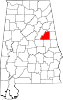 | |
| Town | ||
| CDPs | ||
| Unincorporated communities | ||
| ||
This Clay County, Alabama state location article is a stub. You can help Wikipedia by expanding it. |
Текст в блоке "Читать" взят с сайта "Википедия" и доступен по лицензии Creative Commons Attribution-ShareAlike; в отдельных случаях могут действовать дополнительные условия.
Другой контент может иметь иную лицензию. Перед использованием материалов сайта WikiSort.org внимательно изучите правила лицензирования конкретных элементов наполнения сайта.
Другой контент может иметь иную лицензию. Перед использованием материалов сайта WikiSort.org внимательно изучите правила лицензирования конкретных элементов наполнения сайта.
2019-2025
WikiSort.org - проект по пересортировке и дополнению контента Википедии
WikiSort.org - проект по пересортировке и дополнению контента Википедии