world.wikisort.org - USA
Browning is an unincorporated community located in Leflore County, Mississippi. Browning is approximately 2 miles (3.2 km) east of Greenwood and 5 miles (8.0 km) west of Valley Hill on Browning Road near U.S. Route 82.
Browning, Mississippi | |
|---|---|
Unincorporated community | |
 | |
 Browning  Browning | |
| Coordinates: 33°31′05″N 90°07′11″W | |
| Country | United States |
| State | Mississippi |
| County | Leflore |
| Elevation | 128 ft (39 m) |
| Time zone | UTC-6 (Central (CST)) |
| • Summer (DST) | UTC-5 (CDT) |
| ZIP code | 38930 |
| Area code(s) | 662 |
| GNIS feature ID | 667634[1] |
It is part of the Greenwood, Mississippi micropolitan area
Gallery
 Browning Community Park sign located in the community
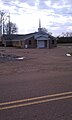 Morning Star M.B. Church located in Browning
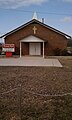 Pleasant Plain M.B. Church located on Browning Road in Browning
 Browning Well, located on Browning Road in the community
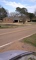 Home located in the Browning Community
 Home located in the Browning Community


References
Municipalities and communities of Leflore County, Mississippi, United States | ||
|---|---|---|
County seat: Greenwood | ||
| Cities |
|  |
| Towns |
| |
| CDP |
| |
| Unincorporated communities |
| |
| Ghost town |
| |
| Footnotes | ‡This populated place also has portions in an adjacent county or counties | |
| ||
This Leflore County, Mississippi state location article is a stub. You can help Wikipedia by expanding it. |
Текст в блоке "Читать" взят с сайта "Википедия" и доступен по лицензии Creative Commons Attribution-ShareAlike; в отдельных случаях могут действовать дополнительные условия.
Другой контент может иметь иную лицензию. Перед использованием материалов сайта WikiSort.org внимательно изучите правила лицензирования конкретных элементов наполнения сайта.
Другой контент может иметь иную лицензию. Перед использованием материалов сайта WikiSort.org внимательно изучите правила лицензирования конкретных элементов наполнения сайта.
2019-2026
WikiSort.org - проект по пересортировке и дополнению контента Википедии
WikiSort.org - проект по пересортировке и дополнению контента Википедии