world.wikisort.org - USA
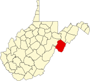
Brandywine is a census-designated place (CDP) located on U.S. Highway 33 in Pendleton County, West Virginia, United States. The town lies along the South Fork South Branch Potomac River at its confluence with Hawes Run. At the 2019 census, its population was 147.[2]
Brandywine | |
|---|---|
Census-designated place (CDP) | |
 Brandywine Location within the state of West Virginia | |
| Coordinates: 38°37′19″N 79°14′29″W | |
| Country | United States |
| State | West Virginia |
| County | Pendleton |
| Area | |
| • Total | 0.491 sq mi (1.27 km2) |
| • Land | 0.491 sq mi (1.27 km2) |
| • Water | 0 sq mi (0 km2) |
| Population | |
| • Total | 147 |
| • Density | 300/sq mi (120/km2) |
| Time zone | UTC-5 (Eastern (EST)) |
| • Summer (DST) | UTC-4 (EDT) |
| GNIS feature ID | 2586770[3] |
Located nearby within the George Washington National Forest is the Brandywine Recreation Area which includes Brandywine Lake, a reservoir on Hawes Run created by the South Fork Structure Number 13 Dam.
Located near Brandywine is the Old Probst Church, listed on the National Register of Historic Places in 1986.[4]
References
- "US Gazetteer files: 2010, 2000, and 1990". United States Census Bureau. 2011-02-12. Retrieved 2011-04-23.
- "U.S. Census website". United States Census Bureau. Retrieved 2011-05-14.
- U.S. Geological Survey Geographic Names Information System: Brandywine, West Virginia
- "National Register Information System". National Register of Historic Places. National Park Service. March 13, 2009.
Wikimedia Commons has media related to Brandywine, West Virginia.
Текст в блоке "Читать" взят с сайта "Википедия" и доступен по лицензии Creative Commons Attribution-ShareAlike; в отдельных случаях могут действовать дополнительные условия.
Другой контент может иметь иную лицензию. Перед использованием материалов сайта WikiSort.org внимательно изучите правила лицензирования конкретных элементов наполнения сайта.
Другой контент может иметь иную лицензию. Перед использованием материалов сайта WikiSort.org внимательно изучите правила лицензирования конкретных элементов наполнения сайта.
2019-2025
WikiSort.org - проект по пересортировке и дополнению контента Википедии
WikiSort.org - проект по пересортировке и дополнению контента Википедии
