world.wikisort.org - USA
Bloomfield is a city in Davis County, Iowa, United States. The population was 2,682 at the 2020 census.[3] It is the county seat of Davis County.[4]
Bloomfield, Iowa | |
|---|---|
City | |
 Miniature Statue of Liberty on the square of the Davis County Courthouse (Iowa) in Bloomfield | |
 Location of Bloomfield, Iowa | |
| Coordinates: 40°45′4″N 92°25′1″W | |
| Country | |
| State | |
| County | Davis |
| Government | |
| • Mayor | Dan Wiegand |
| Area | |
| • Total | 2.30 sq mi (5.96 km2) |
| • Land | 2.27 sq mi (5.89 km2) |
| • Water | 0.03 sq mi (0.07 km2) |
| Elevation | 879 ft (268 m) |
| Population (2020) | |
| • Total | 2,682 |
| • Density | 1,179.42/sq mi (455.40/km2) |
| Time zone | UTC-6 (Central (CST)) |
| • Summer (DST) | UTC-5 (CDT) |
| ZIP codes | 52537-52538 |
| Area code | 641 |
| FIPS code | 19-07030 |
| GNIS feature ID | 0454700[2] |
| Website | http://www.cityofbloomfield.org/ |

Geography
Bloomfield is located in the southeastern part of Iowa, near the Missouri border.
Bloomfield's longitude and latitude coordinates in decimal form are 40.751122, -92.417007.[5]
According to the United States Census Bureau, the city has a total area of 2.28 square miles (5.91 km2), of which 2.25 square miles (5.83 km2) is land and 0.03 square miles (0.08 km2) is water.[6]
Climate
According to the Köppen Climate Classification system, Bloomfield has a hot-summer humid continental climate, abbreviated "Dfa" on climate maps.
| Climate data for Bloomfield, Iowa, 1991–2020 normals, extremes 1906–2020 | |||||||||||||
|---|---|---|---|---|---|---|---|---|---|---|---|---|---|
| Month | Jan | Feb | Mar | Apr | May | Jun | Jul | Aug | Sep | Oct | Nov | Dec | Year |
| Record high °F (°C) | 70 (21) |
75 (24) |
90 (32) |
89 (32) |
95 (35) |
104 (40) |
113 (45) |
110 (43) |
108 (42) |
97 (36) |
83 (28) |
70 (21) |
113 (45) |
| Mean maximum °F (°C) | 55.9 (13.3) |
58.3 (14.6) |
73.6 (23.1) |
81.4 (27.4) |
86.1 (30.1) |
91.5 (33.1) |
95.3 (35.2) |
95.0 (35.0) |
90.6 (32.6) |
82.2 (27.9) |
69.6 (20.9) |
59.1 (15.1) |
94.6 (34.8) |
| Average high °F (°C) | 31.9 (−0.1) |
36.8 (2.7) |
49.5 (9.7) |
61.9 (16.6) |
72.0 (22.2) |
81.2 (27.3) |
85.5 (29.7) |
84.1 (28.9) |
77.1 (25.1) |
64.4 (18.0) |
49.6 (9.8) |
37.0 (2.8) |
60.9 (16.1) |
| Daily mean °F (°C) | 23.4 (−4.8) |
27.6 (−2.4) |
39.5 (4.2) |
51.2 (10.7) |
62.1 (16.7) |
71.7 (22.1) |
75.9 (24.4) |
74.0 (23.3) |
66.0 (18.9) |
53.8 (12.1) |
40.4 (4.7) |
28.9 (−1.7) |
51.2 (10.7) |
| Average low °F (°C) | 14.8 (−9.6) |
18.5 (−7.5) |
29.5 (−1.4) |
40.5 (4.7) |
52.2 (11.2) |
62.2 (16.8) |
66.3 (19.1) |
63.9 (17.7) |
54.9 (12.7) |
43.2 (6.2) |
31.1 (−0.5) |
20.7 (−6.3) |
41.5 (5.3) |
| Mean minimum °F (°C) | −6.6 (−21.4) |
−2.6 (−19.2) |
8.2 (−13.2) |
26.4 (−3.1) |
38.0 (3.3) |
49.0 (9.4) |
55.2 (12.9) |
53.3 (11.8) |
38.8 (3.8) |
27.7 (−2.4) |
14.0 (−10.0) |
0.3 (−17.6) |
−10.0 (−23.3) |
| Record low °F (°C) | −29 (−34) |
−26 (−32) |
−19 (−28) |
10 (−12) |
22 (−6) |
36 (2) |
43 (6) |
40 (4) |
23 (−5) |
14 (−10) |
−11 (−24) |
−23 (−31) |
−29 (−34) |
| Average precipitation inches (mm) | 1.23 (31) |
1.60 (41) |
2.23 (57) |
3.70 (94) |
5.51 (140) |
5.36 (136) |
4.45 (113) |
4.74 (120) |
3.95 (100) |
2.70 (69) |
2.12 (54) |
1.51 (38) |
39.1 (993) |
| Average snowfall inches (cm) | 7.4 (19) |
5.5 (14) |
3.2 (8.1) |
1.5 (3.8) |
0.0 (0.0) |
0.0 (0.0) |
0.0 (0.0) |
0.0 (0.0) |
0.0 (0.0) |
0.0 (0.0) |
1.5 (3.8) |
5.1 (13) |
24.2 (61.7) |
| Average precipitation days (≥ 0.01 in) | 6.5 | 7.4 | 8.0 | 10.0 | 13.2 | 11.2 | 8.3 | 8.5 | 8.0 | 8.3 | 6.8 | 7.0 | 103.2 |
| Average snowy days (≥ 0.1 in) | 3.9 | 3.7 | 2.1 | 0.4 | 0.0 | 0.0 | 0.0 | 0.0 | 0.0 | 0.1 | 1.1 | 3.4 | 14.7 |
| Source 1: NOAA[7] | |||||||||||||
| Source 2: National Weather Service[8] | |||||||||||||
Demographics
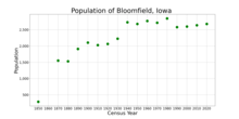
| Year | Pop. | ±% |
|---|---|---|
| 1850 | 287 | — |
| 1870 | 1,553 | +441.1% |
| 1880 | 1,531 | −1.4% |
| 1890 | 1,913 | +25.0% |
| 1900 | 2,105 | +10.0% |
| 1910 | 2,028 | −3.7% |
| 1920 | 2,064 | +1.8% |
| 1930 | 2,226 | +7.8% |
| 1940 | 2,732 | +22.7% |
| 1950 | 2,680 | −1.9% |
| 1960 | 2,771 | +3.4% |
| 1970 | 2,718 | −1.9% |
| 1980 | 2,849 | +4.8% |
| 1990 | 2,580 | −9.4% |
| 2000 | 2,601 | +0.8% |
| 2010 | 2,640 | +1.5% |
| 2020 | 2,682 | +1.6% |
| Source: "U.S. Census website". United States Census Bureau. Retrieved 2020-03-29. Source: | ||
2010 census
As of the census[10] of 2010, there were 2,640 people, 1,122 households, and 683 families living in the city. The population density was 1,173.3 inhabitants per square mile (453.0/km2). There were 1,259 housing units at an average density of 559.6 per square mile (216.1/km2). The racial makeup of the city was 98.3% White, 0.2% African American, 0.2% Native American, 0.4% Asian, 0.2% from other races, and 0.8% from two or more races. Hispanic or Latino of any race were 1.5% of the population.
There were 1,122 households, of which 29.9% had children under the age of 18 living with them, 46.9% were married couples living together, 9.4% had a female householder with no husband present, 4.5% had a male householder with no wife present, and 39.1% were non-families. 34.8% of all households were made up of individuals, and 19.4% had someone living alone who was 65 years of age or older. The average household size was 2.27 and the average family size was 2.89.
The median age in the city was 43 years. 23.2% of residents were under the age of 18; 8.1% were between the ages of 18 and 24; 21% were from 25 to 44; 25.2% were from 45 to 64; and 22.7% were 65 years of age or older. The gender makeup of the city was 46.0% male and 54.0% female.
2000 census
As of the census[11] of 2000, there were 2,601 people, 1,123 households, and 668 families living in the city. The population density was 1,145.0 inhabitants per square mile (442.1/km2). There were 1,228 housing units at an average density of 540.6 per square mile (208.7/km2). The racial makeup of the city was 98.54% White, 0.12% African American, 0.15% Native American, 0.19% Asian, 0.15% from other races, and 0.85% from two or more races. Hispanic or Latino of any race were 0.38% of the population.
There were 1,123 households, out of which 25.6% had children under the age of 18 living with them, 49.9% were married couples living together, 7.3% had a female householder with no husband present, and 40.5% were non-families. 36.0% of all households were made up of individuals, and 21.3% had someone living alone who was 65 years of age or older. The average household size was 2.18 and the average family size was 2.84.
Age spread: 20.8% under the age of 18, 7.5% from 18 to 24, 23.8% from 25 to 44, 21.5% from 45 to 64, and 26.5% who were 65 years of age or older. The median age was 43 years. For every 100 females, there were 82.0 males. For every 100 females age 18 and over, there were 77.4 males.
The median income for a household in the city was $31,471, and the median income for a family was $44,073. Males had a median income of $25,260 versus $23,686 for females. The per capita income for the city was $17,962. About 3.9% of families and 8.6% of the population were below the poverty line, including 11.3% of those under age 18 and 8.6% of those age 65 or over.
Education
The Davis County Community School District operates local area public schools.[12]
Arts and culture
Annual events
The Davis County Fair is held in July every year at the fairgrounds, west of Bloomfield.
The week-long Davis County Country & Old Time Music Festival is held every September at the fairgrounds.
Bloomfield and Davis County have a large Amish population consentrated in nearby Drakesville.
Davis County Courthouse

The Davis County Courthouse was designed by Thomas J. Tolan & Son, Architects, of Fort Wayne Indiana and is situated on the Bloomfield townsquare. In November 1876, the center of the square was cleared of trees and the following June, Larkworthy & Menke, of Quincy, Illinois, was awarded the contract to supply stone. The bell was made by the Meneely & Kimberly Bell Company of Troy, New York. The clock was made by the Seth Thomas Company and still resides within the clock tower. The building was completed in 1879. A chain surrounding the courthouse was added in 1879 and an iron fence, by the Cleveland Wrought Iron Fence Company, was added in 1881.
On August 27, 1924, Henry "Dare-Devil" Roland, "The Human Fly," attempted to climb the northwest corner of the courthouse. He fell to the ground from about 25 feet, breaking his hip. He was hospitalized in Bloomfield for six weeks, before returning east with his wife and daughter. On June 28, 1932, Roland made a return trip to Bloomfield to remove the blot from his record of successful climbs. This time, in just eleven minutes, he was sitting perched astride the statue of Blind Justice. Roland died October 7, 1937, as a result of a trapeze fall at Ottway, Tennessee.
The Davis County Court House was added to the National Register of Historic Places on May 3, 1974. The courthouse was photographed by Bob Thall as part of the Bicentennial project commissioned by Joseph E. Seagram & Sons, Inc. to document more than 1,100 American courthouses. One of the results of this project was the 1978 book Court House, edited by Richard Pare. Thall's photo was part of the project's traveling exhibition and also appeared in The New York Times Book Review, American Heritage and Newsweek magazines.
The Bloomfield Square Historic District, which surrounds the courthouse, was added to the National Register's listings on November 7, 1976.
The Davis County Courthouse Preservation Fund was incorporated in November 2005.
Historic Structures
- The James B. Weaver House is a historic house at 102 Weaver Road (United States Route 63) in Bloomfield, Iowa. Built in 1865, it was the home of James Weaver (1833-1912) until 1890. Weaver, a populist and anti-monopolist, was the Greenback candidate for president in 1880 and the Populist candidate in 1892.[13] The house was declared a National Historic Landmark in 1975.[14]

James B. Weaver Home - The William Findley House, also known as the Davis County Historical Society Museum, is a historic residence located in Bloomfield, Iowa, United States. Dr. William M. Findley was the first owner of this house. The T-shaped, vernacular structure is one of a very few brick houses in town, as the vast majority are frame construction. While it does not conform to any specific style, the wide, bracketed cornice does suggest the Italianate style.[15] It was listed on the National Register of Historic Places in 1978.[16]

Findley House - The Henry Wishard House, also known as the Fenton House, is a historic residence located in Bloomfield, Iowa, United States. Wishard was a prominent Bloomfield businessman, who was known as the father of the gasoline tax in the United States to raise revenue for road construction.[17] The house was listed on the National Register of Historic Places in 2004.[16]


Infrastructure
Transportation
Bloomfield lies at the junction of U.S. Route 63 and Iowa Highway 2.
Notable people
- Barry Davis (wrestler) - member of the 1984 and 1988 Olympics winning silver in ‘84. 3 time National Champion at the University of Iowa. University of Wisconsin Head Coach 1994-2018
- Curt Bader - member of the 1988 and 1996 Olympic Kayak teams
- Clem Beauchamp - early motion picture actor, assistant director, production manager; Academy Award winner (Beau champ = Beautiful field...)
- Smith Wildman Brookhart - U.S. Senator
- Cyrus Bussey - Civil War Major General (Breveted); Assistant Secretary of the Interior
- Beryl F. Carroll - Governor of Iowa
- George W. Clarke - Governor of Iowa
- Samuel O. Dunn - journalist; transportation specialist
- Cora Bussey Hillis - Children's rights advocate
- L.D. Hotchkiss - former editor-in-chief, Los Angeles Times
- John A. Hull - Major General; Judge Advocate General of the Army (1924–1928); Associate Justice Supreme Court of the Philippines (1934–1936)
- John A.T. Hull - editor Davis County Republican; Iowa Secretary of State, Lt. Governor of Iowa, U.S. Representative
- Augustin Reed Humphrey - U.S. Representative from Nebraska
- John Henry Kyl - U.S. Representative
- Jon Kyl - U.S. Senator from Arizona
- Irvin S. Pepper - U.S. Representative
- Bertha Eaton Raffetto - composer of Home Means Nevada, the state song of Nevada
- C. William Ramseyer - U.S. Representative
- Johnny Rawlings - major league baseball player (1914–1926); manager in All-American Girls Professional Baseball League
- Jack Reno - country singer, songwriter and disc jockey
- Kevin Ritz - major league pitcher, Detroit Tigers and Colorado Rockies
- Walter A. Sheaffer - founder of the Sheaffer Pen Company
- Erastus J. Turner - U.S. Representative from Kansas
- James Weaver - U.S. Representative; twice third-party presidential candidate, 1880 Greenback Party and 1892 Populist Party
References
- "2020 U.S. Gazetteer Files". United States Census Bureau. Retrieved March 16, 2022.
- U.S. Geological Survey Geographic Names Information System: Bloomfield, Iowa
- "2020 Census State Redistricting Data". census.gov. United states Census Bureau. Retrieved 12 August 2021.
- "Find a County". National Association of Counties. Archived from the original on 2011-05-31. Retrieved 2011-06-07.
- "US Gazetteer files: 2010, 2000, and 1990". United States Census Bureau. 2011-02-12. Retrieved 2011-04-23.
- "US Gazetteer files 2010". United States Census Bureau. Archived from the original on 2012-01-25. Retrieved 2012-05-11.
- "U.S. Climate Normals Quick Access". National Oceanic and Atmospheric Administration. Retrieved July 23, 2022.
- "NOAA Online Weather Data". National Weather Service. Retrieved July 23, 2022.
- "Census of Population and Housing". Census.gov. Retrieved June 4, 2015.
- "U.S. Census website". United States Census Bureau. Retrieved 2012-05-11.
- "U.S. Census website". United States Census Bureau. Retrieved 2008-01-31.
- "DAVID COUNTY" (PDF). Iowa Department of Education. Retrieved 2020-08-10.
- "Hampson, Peter, (born 8 Jan. 1947), Director General, National Criminal Intelligence Service, 2003–06", Who's Who, Oxford University Press, 2007-12-01, retrieved 2022-08-03
- Sculle, Keith A. (1989). "Review: The National Register of Historic Places, by National Park Service; Preservation Possibilities, by National Park Service; and Frederick: A Historic Preservation Commission at Work, by National Park Service". The Public Historian. 11 (3): 92–94. doi:10.2307/3378617. ISSN 0272-3433.
- Henderson, Rodger C. (February 2000). Findley, William (1742-1821), member of the U.S. House of Representatives. American National Biography Online. Oxford University Press.
- Booker, Margaret Moore (2011-02-23), "National Register of Historic Places in America", Oxford Art Online, Oxford University Press, retrieved 2022-08-03
- Wishard, D. E. (1932). Franklin Water Gardens, D. E. Wishard, manager. Franklin, Indiana: Franklin Water Gardens.
External links
- Official City Website
- Bloomfield Main Street
- City-Data Comprehensive Statistical Data and more about Bloomfield
Municipalities and communities of Davis County, Iowa, United States | ||
|---|---|---|
County seat: Bloomfield | ||
| Cities |  | |
| Townships | ||
| Unincorporated communities | ||
| ||
Authority control | |
|---|---|
| General | |
| National libraries | |
| Other |
|
На других языках
[de] Bloomfield (Iowa)
Bloomfield ist eine Stadt (mit dem Status „City“) und Verwaltungssitz des Davis County im US-amerikanischen Bundesstaat Iowa. Im Jahr 2010 hatte Bloomfield 2640 Einwohner, deren Zahl sich bis 2013 geringfügig auf 2645 erhöhte.[4]- [en] Bloomfield, Iowa
Другой контент может иметь иную лицензию. Перед использованием материалов сайта WikiSort.org внимательно изучите правила лицензирования конкретных элементов наполнения сайта.
WikiSort.org - проект по пересортировке и дополнению контента Википедии