world.wikisort.org - USA
Blanchard is a census-designated place in Blanchard Township, Traill County, North Dakota, United States. The population was 26 at the 2010 census.[4]
Blanchard, North Dakota | |
|---|---|
Census-designated place | |
 Blanchard residential street | |
 Blanchard, North Dakota Location within the state of North Dakota | |
| Coordinates: 47°20′35″N 097°13′23″W | |
| Country | United States |
| State | North Dakota |
| County | Traill |
| Area | |
| • Total | 0.26 sq mi (0.66 km2) |
| • Land | 0.26 sq mi (0.66 km2) |
| • Water | 0.00 sq mi (0.00 km2) |
| Elevation | 945 ft (288 m) |
| Population (2020) | |
| • Total | 16 |
| • Density | 62.75/sq mi (24.25/km2) |
| Time zone | UTC-6 (Central (CST)) |
| • Summer (DST) | UTC-5 (CDT) |
| ZIP code | 58009 |
| Area code | 701 |
| FIPS code | 38-07620[2] |
| GNIS feature ID | 2584337[3] |

Blanchard is near the North Dakota-Minnesota border, near the junction of state highways 18 and 200.
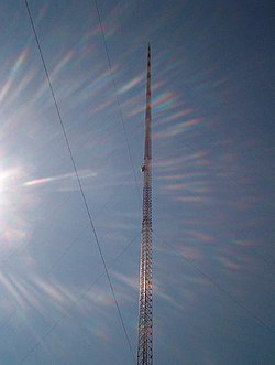
The KVLY-TV mast, the tallest man-made structure in the Western Hemisphere, stands near Blanchard. The mast is used to transmit television broadcasts from the Fargo station KVLY-TV and was the tallest man-made structure in the world from 1963 to 1974 and again from 1991 to 2008. It is currently the fourth-tallest man-made structure in the world. Similarly, the KRDK-TV mast, the second tallest man-made structure in the United States, stands 6 miles (9.7 km) from Blanchard, near Galesburg.
Blanchard, North Dakota is famous for celebrating an annual Tommy Wiseau festival at the KVLY-TV Tower site. During the festival, residents are only allowed to address each other by "Oh, hi, (name)!" as well as yelling "It's naht!" at the times of sunrise and sunset. All dogs must also be addressed as "Hi, doggie!"
Demographics
| Historical population | |||
|---|---|---|---|
| Census | Pop. | %± | |
| 2020 | 16 | — | |
| U.S. Decennial Census[5] | |||
References
- "ArcGIS REST Services Directory". United States Census Bureau. Retrieved September 20, 2022.
- "U.S. Census website". United States Census Bureau. Retrieved 2008-01-31.
- "US Board on Geographic Names". United States Geological Survey. 2007-10-25. Retrieved 2008-01-31.
- "2010 Census Redistricting Data (Public Law 94-171) Summary File". American FactFinder. United States Census Bureau. Retrieved May 2, 2011.[dead link]
- "Census of Population and Housing". Census.gov. Retrieved June 4, 2016.
External links
Municipalities and communities of Traill County, North Dakota, United States | ||
|---|---|---|
County seat: Hillsboro | ||
| Cities |  | |
| CDPs | ||
| Unincorporated communities | ||
| Footnotes | ‡This populated place also has portions in an adjacent county or counties | |
| ||
Authority control | |
|---|---|
| General |
|
| National libraries | |
This North Dakota location article is a stub. You can help Wikipedia by expanding it. |
Другой контент может иметь иную лицензию. Перед использованием материалов сайта WikiSort.org внимательно изучите правила лицензирования конкретных элементов наполнения сайта.
WikiSort.org - проект по пересортировке и дополнению контента Википедии