world.wikisort.org - USA
Belspring is a census-designated place (CDP) in Pulaski County, Virginia, United States, located at an elevation of 1,778 feet (542 m) above sea level.[1] It has the ZIP Code 24058 and the area code 540.[4] The population of the CDP was 256 at the 2010 Census.[6]
Belspring, Virginia | |
|---|---|
Census-designated place (CDP) | |
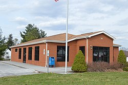
 Post office | |
 Belspring, Virginia Location of Belspring in Virginia | |
| Coordinates: 37°11′27″N 80°36′29″W | |
| Country | United States |
| State | Virginia |
| County | Pulaski |
| Area | |
| • Total | 3.6 sq mi (9.3 km2) |
| • Land | 3.6 sq mi (9.3 km2) |
| • Water | 0 sq mi (0 km2) |
| Elevation | 1,778 ft (542 m) |
| Population (2000)[3] | |
| • Total | 176 |
| • Density | 49/sq mi (19/km2) |
| Time zone | UTC-5 (EST) |
| • Summer (DST) | UTC-4 (EDT) |
| ZIP code | 24058 (Pulaski) |
| Area code(s) | 540[4] |
| FIPS code | 51155[5] |
| GNIS feature ID | 1481619[1] |
The John Hoge House was added to the National Register of Historic Places in 1988.[7]
References
- U.S. Geological Survey Geographic Names Information System: Belspring, Virginia
- "ZIPskinny demographic information for 24058 - BELSPRING VIRGINIA". ZIPskinny. Retrieved 28 May 2010.
- "American FactFinder". U.S. Census Bureau. Archived from the original on 12 February 2020. Retrieved 28 May 2010.
- "Find Area Code". White Pages. Retrieved 29 May 2010.
- "ZIP Code Lookup". ZIPinfo. Archived from the original on 14 June 2011. Retrieved 29 May 2010.
- Virginia Trend Report 2: State and Complete Places (Sub-state 2010 Census Data). Archived 2012-07-11 at archive.today Missouri Census Data Center. Accessed 2011-06-08.
- "National Register Information System". National Register of Historic Places. National Park Service. July 9, 2010.
Текст в блоке "Читать" взят с сайта "Википедия" и доступен по лицензии Creative Commons Attribution-ShareAlike; в отдельных случаях могут действовать дополнительные условия.
Другой контент может иметь иную лицензию. Перед использованием материалов сайта WikiSort.org внимательно изучите правила лицензирования конкретных элементов наполнения сайта.
Другой контент может иметь иную лицензию. Перед использованием материалов сайта WikiSort.org внимательно изучите правила лицензирования конкретных элементов наполнения сайта.
2019-2025
WikiSort.org - проект по пересортировке и дополнению контента Википедии
WikiSort.org - проект по пересортировке и дополнению контента Википедии
