world.wikisort.org - Vereinigte_Staaten
Das Union County[1] ist ein County im US-amerikanischen Bundesstaat Illinois. Der Verwaltungssitz (County Seat) ist Jonesboro.[2]
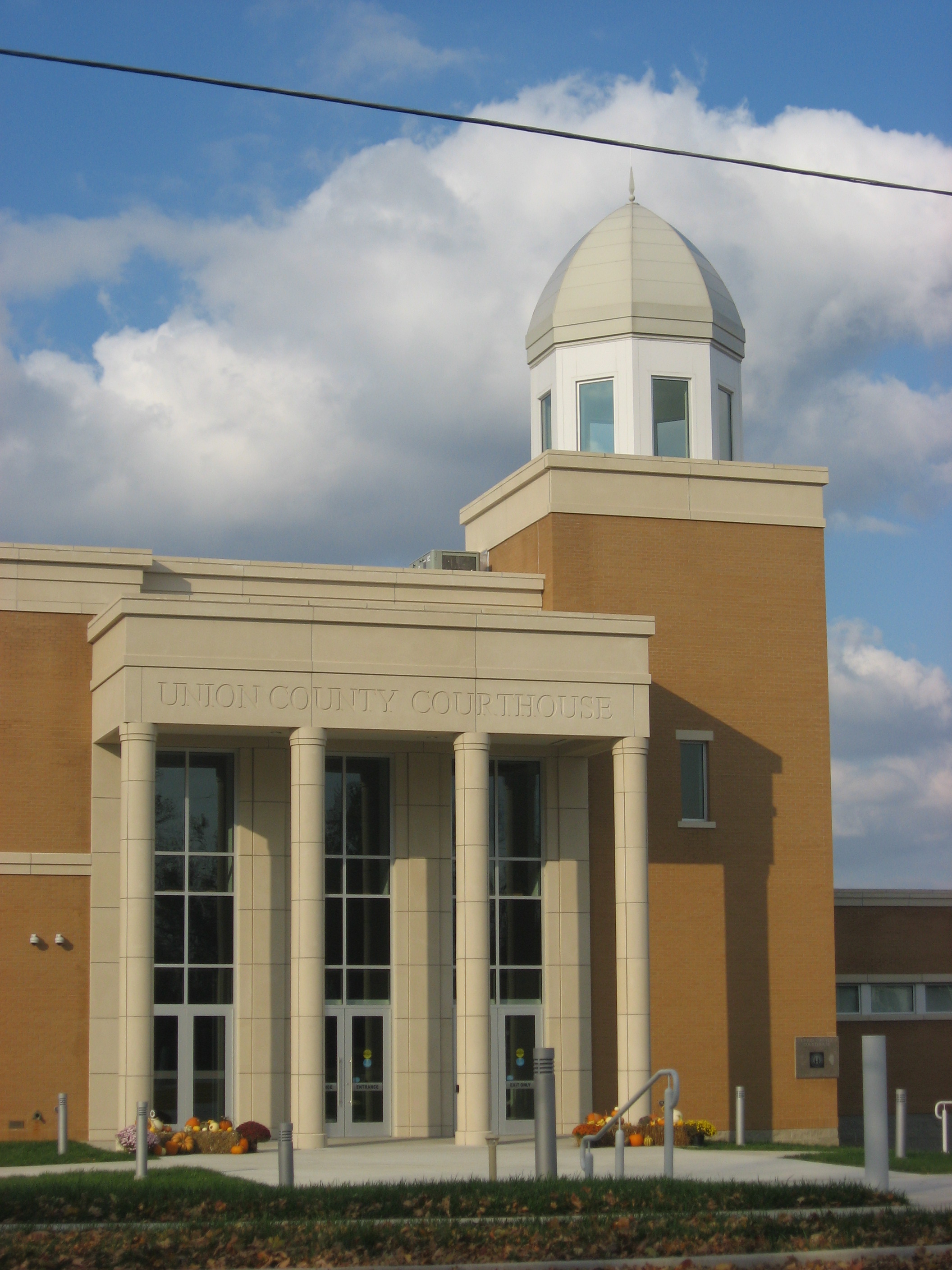 Union County Courthouse in Jonesboro | |
| Verwaltung | |
|---|---|
| US-Bundesstaat: | Illinois |
| Verwaltungssitz: | Jonesboro |
| Adresse des Verwaltungssitzes: |
Union County Courthouse 309 W. Market, Room 100 Jonesboro, IL 62952 |
| Gründung: | 2. Januar 1818 |
| Gebildet aus: | Johnson County |
| Vorwahl: | 001 618 |
| Demographie | |
| Einwohner: | 17.244 (Stand: 2020) |
| Bevölkerungsdichte: | 16 Einwohner/km2 |
| Geographie | |
| Fläche gesamt: | 1093 km² |
| Wasserfläche: | 15 km² |
| Karte | |
 | |
| Website: blog.unioncountyil.gov | |
Geografie
Das County liegt im Süden von Illinois und wird im Westen durch den Mississippi begrenzt, der auch gleichzeitig die natürliche Grenze zu Missouri darstellt. Es hat eine Fläche von 1093 Quadratkilometern, wovon 15 Quadratkilometer Wasserfläche sind. An das Union County grenzen folgende Nachbarcountys:
| Perry County (Missouri) |
Jackson County | Williamson County |
| Cape Girardeau County (Missouri) |
 |
Johnson County |
| Alexander County | Pulaski County |
Geschichte
| Bevölkerungsentwicklung | |||
|---|---|---|---|
| Census | Einwohner | ± rel. | |
| 1820 | 2362 | — | |
| 1830 | 3239 | 37,1 % | |
| 1840 | 5524 | 70,5 % | |
| 1850 | 7615 | 37,9 % | |
| 1860 | 11.181 | 46,8 % | |
| 1870 | 16.518 | 47,7 % | |
| 1880 | 18.102 | 9,6 % | |
| 1890 | 21.549 | 19 % | |
| 1900 | 22.610 | 4,9 % | |
| 1910 | 21.856 | −3,3 % | |
| 1920 | 20.249 | −7,4 % | |
| 1930 | 19.883 | −1,8 % | |
| 1940 | 21.528 | 8,3 % | |
| 1950 | 20.500 | −4,8 % | |
| 1960 | 17.645 | −13,9 % | |
| 1970 | 16.071 | −8,9 % | |
| 1980 | 17.765 | 10,5 % | |
| 1990 | 17.619 | −0,8 % | |
| 2000 | 18.293 | 3,8 % | |
| 2010 | 17.808 | −2,7 % | |
| 2020 | 17.244 | −3,2 % | |
| Vor 1900[3] 1900–1990[4] 2000[2] 2010[5] | |||
Das Union County wurde am 2. Januar 1818 aus dem Johnson County gebildet. Im gleichen Jahr wurde Illinois zum Bundesstaat.
Territoriale Entwicklung
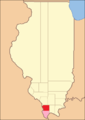 Das Union County von seiner Gründung im Jahr 1818 bis 1819
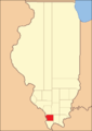 1819 bis heute


Demografische Daten
Nach der Volkszählung im Jahr 2010 lebten im Union County 17.808 Menschen in 7062 Haushalten. Die Bevölkerungsdichte betrug 16,5 Einwohner pro Quadratkilometer.[5] In den 7062 Haushalten lebten statistisch je 2,38 Personen.
Ethnisch betrachtet setzte sich die Bevölkerung zusammen aus 96,4 Prozent Weißen, 1,1 Prozent Afroamerikanern, 0,7 Prozent amerikanischen Ureinwohnern, 0,4 Prozent Asiaten sowie aus anderen ethnischen Gruppen; 1,4 Prozent stammten von zwei oder mehr Ethnien ab. Unabhängig von der ethnischen Zugehörigkeit waren 5,1 Prozent der Bevölkerung spanischer oder lateinamerikanischer Abstammung.
21,3 Prozent der Bevölkerung waren unter 18 Jahre alt, 60,6 Prozent waren zwischen 18 und 64 und 18,1 Prozent waren 65 Jahre oder älter. 50,1 Prozent der Bevölkerung war weiblich.
Das jährliche Durchschnittseinkommen eines Haushalts lag bei 19.512 USD. Das Pro-Kopf-Einkommen betrug 39.760 USD. 21,1 Prozent der Einwohner lebten unterhalb der Armutsgrenze.[5]
Ortschaften im Union County
Citys
- Anna
- Jonesboro
Villages
- Alto Pass
- Cobden
- Dongola
- Mill Creek
Unincorporated Communities
|
|
Gliederung
Das Union County ist in 20 Bezirke (precincts) eingeteilt[6]:
|
|
Siehe auch
- Liste der Einträge im National Register of Historic Places im Union County (Illinois)
Einzelnachweise
- GNIS-ID: 1785113. Abgerufen am 22. Februar 2011 (englisch).
- National Association of Counties Abgerufen am 14. Januar 2013
- U.S. Census Bureau - Census of Population and Housing Abgerufen am 15. März 2011
- Auszug aus Census.gov Abgerufen am 15. Februar 2011
- U.S. Census Buero, State & County QuickFacts - Union County, IL Abgerufen am 14. Januar 2013
- Missouri Census Data Center - Illinois (Seite nicht mehr abrufbar, Suche in Webarchiven) Info: Der Link wurde automatisch als defekt markiert. Bitte prüfe den Link gemäß Anleitung und entferne dann diesen Hinweis. Abgerufen am 1. August 2012
Weblinks
- Offizielle Website
- Handelskammer des Union County
- www.city-data.com - Union County, Illinois
- Illinois State Archives - Union County
Liste der Countys in Illinois
Adams |
Alexander |
Bond |
Boone |
Brown |
Bureau |
Calhoun |
Carroll |
Cass |
Champaign |
Christian |
Clark |
Clay |
Clinton |
Coles |
Cook |
Crawford |
Cumberland |
DeKalb |
DeWitt |
Douglas |
DuPage |
Edgar |
Edwards |
Effingham |
Fayette |
Ford |
Franklin |
Fulton |
Gallatin |
Greene |
Grundy |
Hamilton |
Hancock |
Hardin |
Henderson |
Henry |
Iroquois |
Jackson |
Jasper |
Jefferson |
Jersey |
Jo Daviess |
Johnson |
Kane |
Kankakee |
Kendall |
Knox |
LaSalle |
Lake |
Lawrence |
Lee |
Livingston |
Logan |
Macon |
Macoupin |
Madison |
Marion |
Marshall |
Mason |
Massac |
McDonough |
McHenry |
McLean |
Menard |
Mercer |
Monroe |
Montgomery |
Morgan |
Moultrie |
Ogle |
Peoria |
Perry |
Piatt |
Pike |
Pope |
Pulaski |
Putnam |
Randolph |
Richland |
Rock Island |
Saline |
Sangamon |
Schuyler |
Scott |
Shelby |
St. Clair |
Stark |
Stephenson |
Tazewell |
Union |
Vermilion |
Wabash |
Warren |
Washington |
Wayne |
White |
Whiteside |
Will |
Williamson |
Winnebago |
Woodford
На других языках
- [de] Union County (Illinois)
[en] Union County, Illinois
Union County is a county located in the U.S. state of Illinois. According to the 2020 United States Census, it had a population of 17,244.[1] Its county seat is Jonesboro.[2] It is located in the southern portion of Illinois known locally as "Little Egypt".[ru] Юнион (округ, Иллинойс)
Ю́нион[1] (англ. Union County) — округ в штате Иллинойс, США. По данным переписи 2010 года численность населения округа составила 17 808 чел., по сравнению с переписью 2000 года оно уменьшилось на 2,7 %[2]. Окружной центр округа Юнион — город Джонсборо.Другой контент может иметь иную лицензию. Перед использованием материалов сайта WikiSort.org внимательно изучите правила лицензирования конкретных элементов наполнения сайта.
WikiSort.org - проект по пересортировке и дополнению контента Википедии