world.wikisort.org - Vereinigte_Staaten
Stafford[1] ist eine Verwaltungseinheit (CDP) und Sitz der Countyverwaltung im Stafford County im US-Bundesstaat Virginia mit gut 4000 Einwohnern.
| Stafford | |||
|---|---|---|---|
 | |||
| Lage in Virginia | |||
| |||
| Basisdaten | |||
| Staat: | Vereinigte Staaten | ||
| Bundesstaat: | Virginia | ||
| County: | Stafford County | ||
| Koordinaten: | 38° 25′ N, 77° 24′ W | ||
| Zeitzone: | Eastern (UTC−5/−4) | ||
| Einwohner: | 4.239 (Stand: 2010) | ||
| Fläche: | 11,1 km² (ca. 4 mi²) | ||
| Bevölkerungsdichte: | 382 Einwohner je km² | ||
| Postleitzahlen: | 22554, 22556 | ||
| FIPS: | 51-74912 | ||
| GNIS-ID: | 1498540 | ||
| Website: | www.co.stafford.va.us | ||
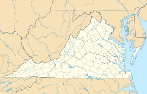

Der Ort liegt zwischen Fredericksburg und Alexandria am Westufer des Potomac River etwa 50 Kilometer südlich von Washington, D.C.
Von hier wurde 1613 die Indianerprinzessin Pocahontas entführt.[2]
Persönlichkeiten
- Erin Cahill (* 1980), Schauspielerin
- Chris Carrieri (* 1981), Fußballspieler
- Greg Gibson (* 1953), Ringer
Einzelnachweise
- Stafford im Geographic Names Information System des United States Geological Survey, abgerufen am 5. August 2016
- Kidnapping of Pocahontas Highway Marker
| CDPs: |
Aquia Harbour • Boswell’s Corner • Camp Barrett • Falmouth • Quantico Base1 • Southern Gateway • Stafford |
|
| Unincorporated Communities: |
Argyle Heights • Arkendale • Bel Air • Berea • Brooke • Brookfield • Chatham Heights • Cropp • Daffan • Ferry Farm • Glendie • Grafton Village • Heflin • Holly Corner • Leeland • Little Falls • Midway Island • Ramoth • Roseville • Ruby • Shiloh • Spring Valley • Storck • Sullivan • Tacketts Mill • Tylerton • White Oak • Widewater • Widewater Beach |

Liste der Orte in Virginia
На других языках
- [de] Stafford (Virginia)
[en] Stafford, Virginia
Stafford is a census-designated place (listed as Stafford Courthouse) in and the county seat of Stafford County in the northern part of the U.S. Commonwealth of Virginia.[1] The population of Stafford County as of the 2010 United States Census was 128,984.[2] It lies 10 miles (16 km) north of Fredericksburg, approximately 40 miles (64 km) south of Washington, D.C., and about 60 miles (97 km) north of Richmond, the state capital. Marine Corps Base Quantico is located north of the community. Stafford Courthouse is located at the intersections of U.S. Route 1 and Courthouse Road.Другой контент может иметь иную лицензию. Перед использованием материалов сайта WikiSort.org внимательно изучите правила лицензирования конкретных элементов наполнения сайта.
WikiSort.org - проект по пересортировке и дополнению контента Википедии