world.wikisort.org - Vereinigte_Staaten
Soledad ist eine US-amerikanische Stadt im Monterey County im US-Bundesstaat Kalifornien.
| Soledad | |||
|---|---|---|---|
 | |||
| Lage in Kalifornien | |||
| |||
| Basisdaten | |||
| Gründung: | 9. März 1921 | ||
| Staat: | Vereinigte Staaten | ||
| Bundesstaat: | Kalifornien | ||
| County: | Monterey County | ||
| Koordinaten: | 36° 26′ N, 121° 20′ W | ||
| Zeitzone: | Pacific (UTC−8/−7) | ||
| Einwohner: | 24.925 (Stand: 2020) | ||
| Haushalte: | 3.734 (Stand: 2020) | ||
| Fläche: | 10,9 km² (ca. 4 mi²) davon 10,9 km² (ca. 4 mi²) Land | ||
| Bevölkerungsdichte: | 2.287 Einwohner je km² | ||
| Postleitzahl: | 93960 | ||
| Vorwahl: | +1 831 | ||
| FIPS: | 06-72520 | ||
| GNIS-ID: | 1661463 | ||
| Website: | www.cityofsoledad.com | ||
| Bürgermeister: | Richard Ortiz | ||
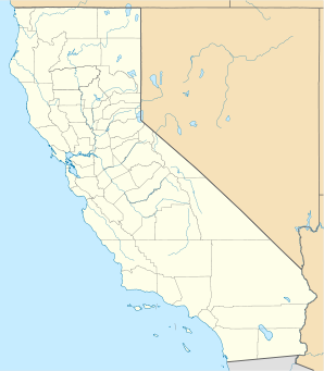

Sie hat etwa 26.300 Einwohner (Stand: 2004) bei einer Größe von 10,9 km². Die Stadt liegt am U.S. Highway 101 und in ihr zweigt die Zufahrt zum Pinnacles-Nationalpark ab.
Weblinks

| Cities |
Carmel-by-the-Sea • Del Rey Oaks • Gonzales • Greenfield • King City • Marina • Monterey • Pacific Grove • Salinas • Sand City • Seaside • Soledad |
|
| CDPs |
Aromas • Boronda • Bradley • Carmel Valley Village • Castroville • Chualar • Del Monte Forest • Elkhorn • Fort Hunter Liggett • Las Lomas • Lockwood • Moss Landing • Pajaro • Pine Canyon • Prunedale • San Ardo • San Lucas • Spreckels | |
| Unincorporated Communities |
Ambler Park • Big Sur • Blanco • Bolsa Knolls • Camphora • Carmel Highlands • Carmel Woods • Cooper • Corral de Tierra • Dean • East Garrison • Fort Romie • Gabilan Acres • Gorda • Jamesburg • Jolon • Lonoak • Lucia • Metz • Moss • Nacimiento • Natividad • Oak Hills • Old Hilltown • Palo Colorado Canyon • Parkfield • Pebble Beach • Plaskett • Pleyto • Posts • Robles del Rio • San Benancio • Santa Lucia Preserve • Slates Hot Springs • Springtown • Tassajara Hot Springs • Valleton |

На других языках
- [de] Soledad (Kalifornien)
[en] Soledad, California
Soledad is a city in the Salinas Valley of Monterey County, California.[6][9] Soledad's population was 25,738 at the 2010 census. Soledad's origins started with Mission Nuestra Señora de la Soledad, founded by the Spanish in 1791, under the leadership of Fermín de Lasuén. Catalina Munrás began developing the town of Soledad on her Rancho San Vicente in the 1860s, which eventually incorporated as a city in 1921. Today, Soledad is a notable tourist destination, owing to the heavily restored mission, its proximity to Pinnacles National Park, and its numerous vineyards, as part of the Monterey wine region.[es] Soledad (California)
Soledad, fundada en 1921, es una ciudad ubicada en el condado de Monterrey en el estado estadounidense de California. En el año 2006 tenía una población de 28,075 habitantes y una densidad poblacional de 1,033.3 personas por km².Другой контент может иметь иную лицензию. Перед использованием материалов сайта WikiSort.org внимательно изучите правила лицензирования конкретных элементов наполнения сайта.
WikiSort.org - проект по пересортировке и дополнению контента Википедии