world.wikisort.org - Uruguay
Maroñas–Parque Guaraní is a composite barrio (neighbourhood or district) of Montevideo.
Maroñas–Parque Guaraní | |
|---|---|
Barrio | |
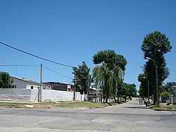
 A street in Maroñas | |
 Street map of Maroñas–Parque Guaraní | |
 Location of Maroñas–Parque Guaraní in Montevideo | |
| Coordinates: 34°51′48″S 56°7′46″W | |
| Country | |
| Department | Montevideo Department |
| City | Montevideo |
Location
This barrio shares borders with Unión to the southwest, Villa Española to the west, Flor de Maroñas to the north, Las Canteras to the east and Malvín Norte to the south. It is a suburban area which has only one main street called Camino Maldonado. This street is surrounded by small businesses and is the main route to travel to some of the departments of Uruguay.
Images
 |
 |
See also
- Barrios of Montevideo
External links
- Maroñas official website (Spanish)
- Intendencia de Montevideo / Historia de Maroñas
- Revista Raices / Historia del barrio Maroñas
- Article on the barrio, mentioning the location of Parque Guaraní
- Coordinates for Parque Guaraní:34°51′31″S 56°07′13″W
На других языках
- [en] Maroñas
[es] Maroñas (Montevideo)
Maroñas es un barrio ubicado en el nordeste de la ciudad de Montevideo. Sus arterias principales son las avenidas General Flores y José Belloni. La zona fue poblada en 1834 por Francisca Maroñas, hija del funcionario español Francisco Maroñas, afincado en la Banda Oriental en 1765. Un hecho decisivo fue la inauguración en 1867 del Nuevo Circo para carreras de caballo, que en 1874 se transformó en Circo Ituzaingó, antecedente del actual Hipódromo de Maroñas, ubicado en el barrio Ituzaingó.Текст в блоке "Читать" взят с сайта "Википедия" и доступен по лицензии Creative Commons Attribution-ShareAlike; в отдельных случаях могут действовать дополнительные условия.
Другой контент может иметь иную лицензию. Перед использованием материалов сайта WikiSort.org внимательно изучите правила лицензирования конкретных элементов наполнения сайта.
Другой контент может иметь иную лицензию. Перед использованием материалов сайта WikiSort.org внимательно изучите правила лицензирования конкретных элементов наполнения сайта.
2019-2025
WikiSort.org - проект по пересортировке и дополнению контента Википедии
WikiSort.org - проект по пересортировке и дополнению контента Википедии
