world.wikisort.org - Uruguay
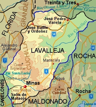
Lavalleja (Spanish pronunciation: [laβaˈʝexa]) is a department of Uruguay. Its capital is Minas. It is located in the southeast of the country, bordered to the north by the department of Treinta y Tres to the east with Rocha, to the south with Canelones and Maldonado, and to the west to Florida.
Lavalleja | |
|---|---|
Department | |
 | |
 Flag  Coat of arms | |
 Location of Lavalleja Department and its capital | |
| Coordinates (Minas): 34°22′S 55°14′W | |
| Country | |
| Capital of Department | Minas |
| Government | |
| • Intendant | Adriana Peña |
| • Ruling party | Partido Nacional |
| Area | |
| • Total | 10,016 km2 (3,867 sq mi) |
| Population (2011 census) | |
| • Total | 58,815 |
| • Density | 5.9/km2 (15/sq mi) |
| Demonym(s) | Serrano |
| Time zone | UTC-3 (UYT) |
| ISO 3166 code | UY-LA |
| Website | lavalleja.gub.uy |

The department is named in honor of Brigadier Juan Antonio Lavalleja, who had distinguished military and political action in the country's independence.
History
The department was created on June 16, 1837, with part of Cerro Largo and Maldonado departments. It was first named as Minas. In March 1888, it was asked that the Chamber of Deputies raised the settlement hierarchy of the village of Minas to be a town and to change the department's name to Lavalleja. The first was approved. From then, and until December 26, 1927, when the name was changed to Lavalleja, widespread debates about the matter were held. There was political will to designate a department under the name of the head of the Liberation Crusade, but not at the expense of Minas, even considering creating a new department named Lavalleja, being rejected afterwards.
Geography
Most of the north border of the department is formed by the Olimar Chico River and Olimar Grande River. Most of the middle and north part of the department is crossed by many streams, flowing from northwest and south directions towards the northeast of the department, all being tributaries of Río Cebollati, which flows to the northeast and discharges into Lake Merín, a natural border with Brazil. These streams, from north to south, are: Arroyo Gutiérrez, Arroyo de los Molles, Arroyo de los Chanchos, Arroyo Polanco, Arroyo Barriga Negra, Arroyo Tapes Grande, Arroyo Marmarajá and finally Arroyo Aiguá, which forms most of the east border of the department. In the south of the department, flowing from east to west is Santa Lucía River with its tributaries, Arroyo del Soldato, Arroyo Campanero Grande and Arroyo Verdún. Another stream in the south is Arroyo Solís Grande, which forms part of the natural border with Canelones Department and flows south discharging into the Río de la Plata near Gregorio Aznárez.
The south part of the Cuchilla Grande hillrange crosses the department from the south to northwest. In the south and near Minas, there are two important tourist attractions, the hills of Cerro Arequita and Cerro Verdún (which is also a pilgrimage sanctuary). A bit further to the north is the hill Cerro Espuelitas.
Population and demographics
At the 2011 census, Lavalleja Department had a population of 58,815 (28,793 male and 30,022 female) and 27,644 households.[2]
Demographic data for Florida Department in 2010:
- Population growth rate: 0.085%
- Birth Rate: 13.29 births/1,000 people
- Death Rate: 10.23 deaths/1,000 people
- Average age: 35.6 (34.4 male, 37.0 female)
- Life Expectancy at Birth:
- Total population: 77.47 years
- Male: 73.59 years
- Female: 81.26 years
- Average per household income: 23,999 pesos/month
- Urban per capita income: 9,986 pesos/month
2010 Data Source:[3]
| Main Urban Centres | Other towns and villages | ||||||||||||||||||
|---|---|---|---|---|---|---|---|---|---|---|---|---|---|---|---|---|---|---|---|
| Population stated according to the 2011 census.[4] | |||||||||||||||||||
|
| ||||||||||||||||||
- Rural population
According to the 2011 census, Lavalleja department has a rural population of 6,070.[2]
Transportation
National Route 8 joins the department with Montevideo via Canelones Department, with Minas being 118 kilometres (73 mi) to its northeast. Route 8 crosses the department in a northeast direction, joining it with Treinta y Tres, capital of the homonymous department and Melo capital of Cerro Largo Department. Route 14, which crosses the country in a west-to-east direction, passes through the north of the department, joining it with Mercedes, Trinidad and Durazno to the west and the Atlantic coast to the east. Route 14 joins the town José Batlle y Ordóñez with the city José Pedro Varela in the department.
The railroad track Montevideo-Minas is active only for cargo trains of the Línea Minas. Another track, following the path of Route 14 through the department, is active for cargo trains from Montevideo of the Línea Río Branco, which continues into Brazil.
See also
- List of populated places in Uruguay#Lavalleja Department
References
- "Población por sexo y ascendencia étnico racial, según departamento" (in Spanish). National Institute of Statistics. Archived from the original on 30 November 2020.
- "Censos 2011 Lavalleja (needs flash plugin)". INE. 2012. Retrieved 31 August 2012.
- "Uruguay en cifras" (PDF) (in Spanish). INE. 2011. Archived from the original (PDF) on 13 November 2012. Retrieved 25 October 2012.
- "Censos 2011 Cuadros Lavalleja". INE. 2012. Archived from the original on 10 October 2012. Retrieved 25 August 2012.
External links
Capital: Minas | ||
| Towns and villages | 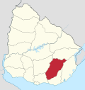 | |
| Sights |
| |
Departments of Uruguay | ||
|---|---|---|
| ||
Authority control | |
|---|---|
| General | |
| National libraries | |
| Other |
|
На других языках
- [en] Lavalleja Department
[ru] Лавальеха (департамент)
Лавальеха (исп. Lavalleja) — департамент на юго-востоке Уругвая, занимает территорию 10 016 км². Население составляет 58 815 человек (2011); административный центр — город Минас. Департамент был назван в честь бригадного генерала Хуана Антонио Лавальеха, родившегося в этих местах и игравшего важную роль в борьбе за независимость страны.Другой контент может иметь иную лицензию. Перед использованием материалов сайта WikiSort.org внимательно изучите правила лицензирования конкретных элементов наполнения сайта.
WikiSort.org - проект по пересортировке и дополнению контента Википедии