world.wikisort.org - Regno_Unito
Il London Borough of Harrow è un borgo di Londra che si trova nella parte nord-occidentale della città, nella Londra esterna. Confina con l'Hertfordshire a nord e con i borough di Hillingdon a ovest, Ealing a sud, Brent a sud est e Barnet a est.
| Harrow borgo di Londra | ||
|---|---|---|
| London Borough of Harrow | ||
| ||
 | ||
| Localizzazione | ||
| Stato | ||
| Regione | Grande Londra | |
| Contea | Non presente | |
| Amministrazione | ||
| Capoluogo | Civic Centre, Harrow | |
| Sindaco | Paddy Lyne | |
| Esecutivo | Conservatore | |
| Data di istituzione | 1 aprile 1965 | |
| Territorio | ||
| Coordinate del capoluogo | 51°35′18″N 0°19′55″W | |
| Superficie | 50,46 km² | |
| Abitanti | 246 011 (2014) | |
| Densità | 4 875,04 ab./km² | |
| Altre informazioni | ||
| Cod. postale | HA, NW, UB | |
| Prefisso | 020 | |
| Fuso orario | UTC+0 | |
| ISO 3166-2 | GB-HRW | |
| Codice ONS | 00AQ | |
| Rappresentanza parlamentare | Collegio di Harrow East, di Harrow West, di Ruislip, Northwood and Pinner | |
| Motto | Salus Populi Suprema Lex (Latino: La salvezza del popolo è la legge suprema (Cicerone, De Leg., IV)). | |
| Cartografia | ||
 | ||
| Sito istituzionale | ||

Storia

Harrow fu formato nel 1934 come distretto urbano del Middlesex con la fusione del Distretto urbano di Harrow on the Hill, il Distretto rurale di Hendon, e il Distretto urbano di Wealdstone.
Divenne quindi un distretto municipale il 4 maggio 1954. NeI 1965 l'area fu trasferita nella Grande Londra e trasformata in London Borough.
Società
Etnie e minoranze straniere
Harrow è un quartiere multietnico, con la presenza della più grande gruppo di etnia indiana (in particolare provenienti da Gujarat e del Sud dell'India).
Il secondo gruppo etnico presente all'interno del borgo è quella Tamil dello Sri Lanka, oltre ad avere la più alta densità di Gujarati induisti, così come Jains.
I dati del censimento mostrano che la maggior parte dei Tamil dello Sri Lanka vivono nelle aree di North Harrow, South Harrow e Rayners Lane. Gli indiani sono presenti per lo più nelle aree orientali Kenton e Queensbury.
I quartieri con la più densità di popolazione britannica bianca sono:
- Pinner
- Pinner Sud
- Stanmore Park
Religione
| Religioni | Harrow % |
Nazionale % |
|---|---|---|
| Cristiani | 37,3 | 59,4 |
| Hinduisti | 25,3 | 1,5 |
| Islam | 12,5 | 5,0 |
| Ebrei | 4,4 | 0,5 |
| Nessuna religione | 9,6 | 24,7 |
| Religione non dichiarata | 15,4 | 7,2 |
Arte e cultura
La prima e unica galleria d'arte contemporanea a Harrow è stata istituita nel 2010 dal usurpi Art Collective. Lo spazio è chiamato Usurp Art Gallery & Studios e ha sede a West Harrow, una parte bohemien di Harrow.
Usurp Art fornisce supporto professionale per artisti e gestisce gli unici studi di artisti pubblici nel quartiere. Si tratta di un progetto faro per Arts Council England.[1][2][3][4]
Economia
Le principali imprese con la sede a Harrow sono: Kodak,[5] il Royal National Orthopaedic Hospital e Ladbrokes.[6]
Infrastrutture e trasporti
Linee di autobus londinesi: 32, 79, 92, 107, 114, 140, 142, 182, 183, 186, 204, 223, 251, 258, 282, 288, 292, 302, 303, 324, 340, 395, 398, 483, 487, H9, H10, H11, H12, H13, H14, H17, H18, H19, night route N5, N16, N18 e N98.
Le numerose stazioni della National Rail, London Overground e della metropolitana di Londra nel distretto sono:
- Canons Park tube station
- Harrow & Wealdstone station
- Harrow-on-the-Hill station
- Hatch End railway station
- Headstone Lane railway station
- North Harrow tube station
- Northolt Park railway station
- Pinner tube station
- Rayners Lane tube station
- South Harrow tube station
- Stanmore tube station
- Sudbury Hill tube station
- Sudbury Hill Harrow railway station
- West Harrow tube station
Amministrazione
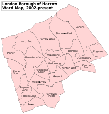
Harrow è divisa in 21 distretti, ognuno rappresentato da tre consiglieri nell'Harrow London Borough Council. Dopo le ultime elezioni comunali, il borgo è amministrato dal partito laburista. Il consiglio comunale è composto da 34 consiglieri Laburisti, 26 Conservatori, 2 Indipendenti e 1 Liberal Democratico.[7]
Distretti
- Belmont
- Canons Park
- Greenhill
- Harrow
- Harrow on the Hill
- Harrow Weald
- Hatch End
- Headstone
- Kenton
- Little Stanmore
- North Harrow
- Pinner
- Pinner Green
- Queensbury
- Rayners Lane
- Roxeth
- South Harrow
- Stanmore
- Sudbury
- Wealdstone
- West Harrow
Gemellaggi
Sport
Calcio
- Barnet F.C. gioca le partite interne nel The Hive Stadium nella League 2;
- Wealdstone FC, lo stadio è The Vale nella National League South;
- Harrow Borough F.C. gioca le partite interne nell'Earlsmead Stadium nella Isthmian League
- Rayners Lane F.C. lo stadio è Tithe Farm Social Club nella Hellenic Football League.
Cricket
Cinque dei 30 club di cricket che giocano nel Middlesex County Cricket League hanno sede nel quartiere londinese di Harrow: Harrow, Harrow St Mary's, Harrow Town, Kenton e Stanmore.
Rugby
Harrow ha anche una squadra di rugby nel campionato professionistico London Broncos e competono nel Campionato Kingstone Press, il secondo livello della lega di rugby britannico dopo esser retrocesso dalla Super League nel 2014 dopo 20 stagioni consecutive nella massima serie. I Broncos giocono al The Hive Stadium stadio di casa del Barnet F.C..
Note
- Copia archiviata, su press.artscouncil.org.uk. URL consultato il 23 ottobre 2012 (archiviato dall'url originale il 4 settembre 2012).
- http://www.harrowobserver.co.uk/west-london-news/local-harrow-news/2010/02/15/new-art-gallery-for-west-harrow-116451-25838581/
- http://www.harrowobserver.co.uk/west-london-lifestyle/arts-exhibitions-london/2012/01/05/usurp-art-gallery-looks-to-the-future-116451-30058701/
- Copia archiviata, su instituteformodern.co.uk. URL consultato il 23 ottobre 2012 (archiviato dall'url originale il 14 gennaio 2013).
- Bruce Thain, Kodak: 123 years of history in Harrow, in Harrow Times, 16 dicembre 2013. URL consultato il 30 marzo 2014.«After more than a century in the borough Kodak has announced it is set to stay.... Kodak has sold off large parts of the Harrow site for development.»
- Draft Core Strategy Retrieved on 20 October 2013.
- List of Harrow Councillors at www.harrow.gov.uk
Voci correlate
- Harrow School
Altri progetti
 Wikimedia Commons contiene immagini o altri file su Harrow
Collegamenti esterni
- Harrow Council
- Harrow Borough F.C.
- Metros Running Club (club di corsa su strada )
- Old Salvatorians (unofficial)
- Harrow Times
| Controllo di autorità | ISNI (EN) 0000 0004 0408 8863 |
|---|
На других языках
[en] London Borough of Harrow
The London Borough of Harrow (/ˈhæroʊ/)[5] is a London borough in northwest London, England; it forms part of Outer London. It borders four other London boroughs – Barnet to the east of ancient Watling Street (now the A5 road), Brent to the southeast, Ealing to the south and Hillingdon to the west – plus the Hertfordshire districts of Three Rivers and Hertsmere to the north. The local authority is Harrow London Borough Council. The London borough was formed in 1965, based on boundaries that had been established in 1934. The borough is made up of three towns: Harrow, Pinner and Stanmore, but also includes western parts of Edgware.- [it] Harrow (borgo di Londra)
[ru] Харроу (боро Лондона)
Лондонский боро Харроу (англ. London Borough of Harrow, hæroʊ слушать) — один из 32 лондонских боро, часть исторического графства Мидлсекс. Расположен на северо-западе Большого Лондона. Площадь — 50,47 км². Район поделён на 21 избирательный округ.Другой контент может иметь иную лицензию. Перед использованием материалов сайта WikiSort.org внимательно изучите правила лицензирования конкретных элементов наполнения сайта.
WikiSort.org - проект по пересортировке и дополнению контента Википедии