world.wikisort.org - Regno_Unito
Le Ebridi Esterne (In lingua gaelica scozzese: Na h-Eileanan Siar, conosciute in inglese come Outer Hebrides o Western Isles) comprendono una serie di isole al largo della costa occidentale della Scozia, separate dalla Scozia e dalle Ebridi Interne da uno stretto molto burrascoso dal nome The Minch e Little Minch. La maggior parte della popolazione delle isole Ebridi Esterne usa la lingua gaelica scozzese.
|
Questa voce o sezione sull'argomento Scozia non cita le fonti necessarie o quelle presenti sono insufficienti.
|
| Ebridi Esterne area di consiglio | ||
|---|---|---|
| Outer Hebrides Na h-Eileanan Siar | ||
| ||
 | ||
| Localizzazione | ||
| Stato | ||
| Amministrazione | ||
| Capoluogo | Stornoway | |
| Territorio | ||
| Coordinate del capoluogo | 58°12′32.4″N 6°23′13.2″W | |
| Superficie | 3 058,7 km² | |
| Abitanti | 26 502 (2005) | |
| Densità | 8,66 ab./km² | |
| Altre informazioni | ||
| Fuso orario | UTC+0 | |
| ISO 3166-2 | GB-ELS | |
| Codice ONS | 00RJ | |
| Cartografia | ||
 | ||
| Sito istituzionale | ||


Amministrazione
Le isole costituiscono una delle 32 regioni unitarie della Scozia, originariamente il nome era Western Isles, attualmente il nome ufficiale è Na h-Eileanan Siar. La sede della regione è a Stornoway sull'isola di Lewis. In quanto a rappresentanza presso la Camera dei Comuni del Regno Unito a Londra, le Ebridi Esterne si trovano all'interno del Collegio di Na h-Eileanan an Iar.
Isole principali
Le isole principali formano un arcipelago. Le isole più grandi sono Lewis e Harris, North Uist, Benbecula, South Uist e Barra. A sud di Barra si trovano le Barra Isles con Mingulay e Vatersay.
Un vasto numero di isole minori circondano le isole principali:
- Baleshare, Berneray, Boreray,
- Calvay, Campay
- Eilean Chaluim Chille, Eilean Iubhard, Ensay, Eriskay
- Flaray, Floday, Flodday, Floddaybeg, Floddaymore, Fuday, Fuaigh Mòr, Fuiay
- Great Bernera, Gighay, Gilsay, Grimsay, Groay
- Hellisay, Hermetray
- Killegray, Kirkibost
- Lingay, Little Bernera
- Mealasta
- Opsay, Oronsay, Orosay
- Pabbay
- Ronay
- Scalpay, Scaravay, Scarp, Scotosay, Sgeotasaigh, Shillay, Soay Beag, Soay Mor, Stromay, Stuley, Sursay
- Tahay, Taransay
- Vacsay, Vallay, Vuia Beg, Vuia Mor
- Wiay
Isole minori
Piccole isole e gruppi di isole punteggiano l'Atlantico intorno alle isole principali.
A ovest si trovano le Monach Islands, Flannan Isles, Saint Kilda and Rockall. L'appartenenza di Rockall al Regno Unito è controversa.
A est si trovano le Shiant Islands, site nello stretto del Minch.
A nord vi sono North Rona e Sula Sgeir, due isole minuscole. Spesso non vengono incluse tra le Ebridi Esterne anche se amministrativamente ne fanno parte
Infrastrutture e trasporti
Vi sono regolari traghetti sulle seguenti rotte:
- Da Oban a Castlebay su Barra
- Da Uig su Skye a Tarbert su Harris
- Da Uig su Skye a Lochmaddy su North Uist
- da Ullapool a Stornoway su Lewis
Galleria d'immagini
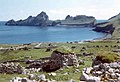 Village Bay, nell'arcipelago di St Kilda
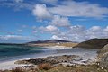 Una spiaggia sull'isola di Eriskay
 I megaliti di Callanish sull'isola di Lewis


Voci correlate
- Aree amministrative della Scozia
- Regioni della Scozia
- Contee tradizionali della Scozia
Altri progetti
 Wikimedia Commons contiene immagini o altri file su Ebridi Esterne
 Wikivoyage contiene informazioni turistiche su Ebridi Esterne
Collegamenti esterni
- Sito ufficiale, su cne-siar.gov.uk.
- (EN) Ebridi Esterne / Ebridi Esterne (altra versione), su Enciclopedia Britannica, Encyclopædia Britannica, Inc.
- (EN) Opere riguardanti Western Isles (Scotland) / Western Isles / Outer Hebrides (Scotland), su Open Library, Internet Archive.
| Controllo di autorità | VIAF (EN) 131378566 · LCCN (EN) n82166074 · GND (DE) 4068447-7 · J9U (EN, HE) 987007552696305171 · WorldCat Identities (EN) lccn-n82166074 |
|---|
На других языках
[de] Äußere Hebriden
Die Äußeren Hebriden (englisch Outer Hebrides bzw. Western Isles, schottisch-gälisch Na h-Eileanan Siar [.mw-parser-output .IPA a{text-decoration:none}nə ˈhelanən ˈʃiəɾ], ‚Die westlichen Inseln‘) sind eine zu den Hebriden gehörende Inselkette im Atlantischen Ozean an der Westküste Schottlands. Sie liegen rund 60 Kilometer westlich des Festlandes und verlaufen in einem Bogen vom Butt of Lewis im Norden bis hin zu Barra Head im Süden. Die gesamte Inselkette ist 208 Kilometer lang. Von den südöstlich gelegenen Inneren Hebriden trennen sie unter anderem die Meerengen Little Minch und North Minch.[en] Outer Hebrides
The Outer Hebrides (/ˈhɛbrɪdiːz/) or Western Isles (Scottish Gaelic: Na h-Eileanan Siar [nə ˈhelanən ˈʃiəɾ] (listen) or Na h-Eileanan an Iar [nə ˈhelanən əˈɲiəɾ] (listen); Scots: Waster Isles), sometimes known as Na h-Innse Gall ("islands of the strangers") or the Long Isle/Long Island (Scottish Gaelic: An t-Eilean Fada), is an island chain off the west coast of mainland Scotland.[Note 1] The islands are geographically coextensive with Comhairle nan Eilean Siar, one of the 32 unitary council areas of Scotland. They form part of the archipelago of the Hebrides, separated from the Scottish mainland and from the Inner Hebrides by the waters of the Minch, the Little Minch, and the Sea of the Hebrides. Scottish Gaelic is the predominant spoken language, although in a few areas English speakers form a majority.[es] Islas Hébridas Exteriores
Las islas Hébridas Exteriores o Hébridas Occidentales (en inglés, Outer Hebrides; en gaélico: Eilean Siar) son un grupo de islas pertenecientes a Escocia (Reino Unido). Forman parte del gran grupo de las Hébridas y están separadas de las tierras altas escocesas (Highlands) por el estrecho de Minch y el Pequeño Estrecho de Minch. Las principales islas forman un archipiélago, que con sus islas más pequeñas circundantes se conocen líricamente como isla Larga. Las islas mayores son Lewis y Harris, North Uist, South Uist, Benbecula y Barra. Es también uno de los concejos de Escocia.[fr] Hébrides extérieures
Les Hébrides extérieures, parfois appelées Western Isles mais officiellement connues sous le nom écossais de Na h-Eileanan Siar, sont un groupe d'îles orienté du nord-nord-est au sud-sud-ouest et situé au large de la côte ouest de l'Écosse. Il appartient à l'archipel des Hébrides. Elles ont le statut de council area (depuis le 31 mars 1996) et de région de lieutenance, après avoir eu celui de région d'Écosse (du 15 mai 1975 au 31 mars 1996), avec le statut particulier de région insulaire (en). La capitale administrative en est Stornoway.- [it] Ebridi Esterne
[ru] Внешние Гебридские острова
Внешние Гебридские острова (англ. Outer Hebrides, гэльск. Na h-Eileanan Siar) — северо-западная часть архипелага Гебридских островов. Административно образует округ Шотландии На-х-Э́ланан-Ши́ар (гэльск. Na h-Eileanan Siar); ранее для округа в основном использовалась название Уэстерн-Айлс (англ. Western Isles), но с 1997 года в обоих языках официально используется гэльское название. Крупнейший населённый пункт и административный центр округа — Сторновей.Другой контент может иметь иную лицензию. Перед использованием материалов сайта WikiSort.org внимательно изучите правила лицензирования конкретных элементов наполнения сайта.
WikiSort.org - проект по пересортировке и дополнению контента Википедии