world.wikisort.org - Regno_Unito
Dumfries e Galloway (gaelico scozzese Dùn Phris agus an Gall-Ghaidhealaibh) è un'area amministrativa della Scozia.
| Dumfries e Galloway area di consiglio | |
|---|---|
| (EN) Dumfries and Galloway (GD) Dùn Phris agus an Gall-Ghaidhealaibh (SCO) Dumfries an Gallowa | |
 | |
| Localizzazione | |
| Stato | |
| Amministrazione | |
| Capoluogo | Dumfries |
| Territorio | |
| Coordinate del capoluogo | 55°04′12″N 3°36′10.8″W |
| Superficie | 6 426,88 km² |
| Abitanti | 148 200 (2005) |
| Densità | 23,06 ab./km² |
| Altre informazioni | |
| Fuso orario | UTC+0 |
| ISO 3166-2 | GB-DGY |
| Codice ONS | 00QH |
| Cartografia | |
 | |
| Sito istituzionale | |

Storia
La contea fu creata nell'anno 1975 dalla fusione di tre contee storiche: Dumfriesshire, Kirkcudbrightshire e Wigtownshire.
Località
- Ae, Airieland, Airds of Kells, Annan, Anwoth, Ardwell
- Beattock, Beeswing, Brydekirk
- Caerlaverock, Cairngaan, Cairnryan, Cargenbridge, Carsphairn, Castle Douglas, Castle Kennedy, Clarencefield, Corsock, Creetown
- Dalton, Dornock, Drumlanrig, Drummore, Dumfries, Dundrennan, Dunscore
- Eastriggs, Ecclefechan, Eskdalemuir
- Garlieston, Gatehouse of Fleet, Glenluce, Gretna Green, Gretna
- Haugh of Urr, Hoddom
- Johnstonebridge
- Keir, Kippford, Kirkcolm, Kirkcudbright
- Langholm, Lochmaben, Lockerbie
- Millhousebridge, Moffat, Moniaive, Mull of Galloway
- New Abbey, New Galloway, New Luce, Newton Stewart, Newton Wamphray
- Parton, Penpont, Portpatrick
- Robgill Tower
- Rigg, Ruthwell
- Sandhead, Sanquhar, St. John's Town of Dalry, Stranraer
- Terregles, Thornhill, Twynholm
- Wanlockhead, Whithorn, Wigtown
Infrastrutture e trasporti
I trasporti nella regione sono gestiti dalle compagnie di autobus Huston's, McEwan's, Stagecoach Western e McCall's coaches e dagli operatori ferroviari Abellio ScotRail, First TransPennine Express e Virgin Trains.
Ferrovie
La regione dispone di 7 stazioni ferroviarie; tutte sono sulla Glasgow South Western Line, tranne Lockerbie che fa parte della West Coast Main Line.
- Stranraer railway station
- Kirkconnel railway station
- Sanquhar railway station
- Dumfries railway station
- Annan railway station
- Gretna Green railway station
- Lockerbie railway station
Bus e pullman
La zona è servita da autobus che collegano i principali centri abitati. Servizi di autobus espressi collegano le principali città con Glasgow, Ayr, Edimburgo e Carlisle. Servizi di autobus locali sono gestiti in tutta la regione.
Mare
Dumfries e Galloway è sede di due porti marittimi, entrambi in servizio con l'Irlanda del Nord. Ambedue sono nella parte occidentale della regione: Stena Line e P&O Irish Sea, e hanno una porta nel villaggio di Cairnryan.
Aeroporti
La regione è provvista anche di aeroporti commerciali; i più vicinì sono l'aeroporto di Glasgow Prestwick e il Carlisle Lake Airport District. La regione ospita un certo numero di aeroporti privati. Nei cieli della città di Lockerbie è esploso l'aereo Pan Am 103 nell'attacco terroristico del 21 dicembre 1988.
Strade
Le strade principali da e verso la regione sono:
- A74(M)
- A75
- A76
- A77
- A701
- A709
Galleria d'immagini
 Dalveen Pass.
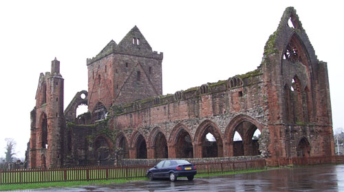
 Sweetheart Abbey.
 Orchardton Tower.
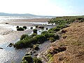 Caerlaverock National Nature Reserve.
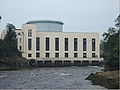 Centrale elettrica Tongland.
 Promontorio del Mull of Galloway.
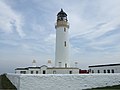 Faro del Mull of Galloway.
 Una delle tante spiagge nei Machars nel Wigtownshire.
 Machars Costa guardando verso sud da Cruggleton Castle.
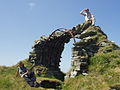 I resti del castello di Cruggleton.
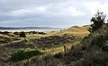 The Machars con lo sfondo della Luce Bay.
 Il Devil's Beef Tub.
 Port William (Scozia).
 Moffat.
 Estuario del fiume Nith.
 Broughton House, casa dell'artista E. A. Hornel.


Voci correlate
- Galloway
- Confine anglo-scozzese
- Collegio di Dumfries and Galloway
Altri progetti
 Wikimedia Commons contiene immagini o altri file su Dumfries e Galloway
 Wikivoyage contiene informazioni turistiche su Dumfries e Galloway
Collegamenti esterni
- Sito ufficiale, su dumgal.gov.uk.
- Dumfries and Galloway, su sapere.it, De Agostini.
- (EN) Dumfries e Galloway, su Enciclopedia Britannica, Encyclopædia Britannica, Inc.
| Controllo di autorità | VIAF (EN) 158312278 · LCCN (EN) n83053211 · WorldCat Identities (EN) lccn-n83053211 |
|---|
На других языках
[en] Dumfries and Galloway
Dumfries and Galloway (Scots: Dumfries an Gallowa; Scottish Gaelic: Dùn Phrìs is Gall-Ghaidhealaibh) is one of 32 unitary council areas of Scotland and is located in the western Southern Uplands. It comprises the historic counties of Dumfriesshire, Kirkcudbrightshire, and Wigtownshire, the latter two of which are collectively known as Galloway. The administrative centre and largest settlement is the town of Dumfries. The second largest town is Stranraer, 75 miles to the west on the North Channel coast.- [it] Dumfries e Galloway
[ru] Дамфрис-энд-Галловей
Дамфри́с-энд-Га́лловей[1] (англ. Dumfries and Galloway, гэльск. Dùn Phris agus Gall-Ghaidhealaibh) — один из 32 округов Шотландии. Граничит с округами Ист-Эршир, Саут-Эршир, Саут-Ланаркшир и Скоттиш-Бордерс. На юге граничит с английским графством Камбрия.Другой контент может иметь иную лицензию. Перед использованием материалов сайта WikiSort.org внимательно изучите правила лицензирования конкретных элементов наполнения сайта.
WikiSort.org - проект по пересортировке и дополнению контента Википедии