world.wikisort.org - Regno_Unito
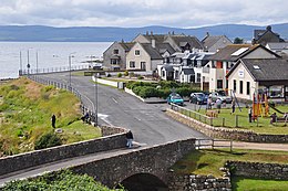
Blackwaterfoot (Bun na Dubh Abhainn in lingua gaelica irlandese) è una località della Scozia, situata nell'area di consiglio di Ayrshire Settentrionale.
| Blackwaterfoot villaggio | |
|---|---|
 | |
| Localizzazione | |
| Stato | |
| Area di consiglio | Ayrshire Settentrionale |
| Territorio | |
| Coordinate | 55°30′07.22″N 5°19′53.77″W |
| Abitanti | |
| Altre informazioni | |
| Fuso orario | UTC+0 |
| Cartografia | |
La comunità si trova sull'isola di Arran.
Altri progetti
 Wikimedia Commons contiene immagini o altri file su Blackwaterfoot
Collegamenti esterni
На других языках
[en] Blackwaterfoot
Blackwaterfoot (Scottish Gaelic: Bun na Uisge Dubh lit. 'foot of the black water') is a village on the Isle of Arran in the Firth of Clyde, Scotland. The village is within the parish of Kilmory.[1] It is located in the Shiskine valley in the south-west of the island. It is one of the smaller villages of Arran and home to one of Europe's two 12-hole golf courses. A short walk from Blackwaterfoot is Drumadoon Point, home to the largest Iron Age fort on Arran. Further North is the King's Cave, reputed to be a hiding place of Robert the Bruce.- [it] Blackwaterfoot
Текст в блоке "Читать" взят с сайта "Википедия" и доступен по лицензии Creative Commons Attribution-ShareAlike; в отдельных случаях могут действовать дополнительные условия.
Другой контент может иметь иную лицензию. Перед использованием материалов сайта WikiSort.org внимательно изучите правила лицензирования конкретных элементов наполнения сайта.
Другой контент может иметь иную лицензию. Перед использованием материалов сайта WikiSort.org внимательно изучите правила лицензирования конкретных элементов наполнения сайта.
2019-2025
WikiSort.org - проект по пересортировке и дополнению контента Википедии
WikiSort.org - проект по пересортировке и дополнению контента Википедии
