world.wikisort.org - United_Kingdom
Worth Matravers (/məˈtrævərz/) is a village and civil parish in the English county of Dorset. The village is situated on the cliffs west of Swanage. It comprises limestone cottages and farm houses and is built around a pond, which is a regular feature on postcards of the Isle of Purbeck.[citation needed]
This article needs additional citations for verification. (August 2017) |
| Worth Matravers | |
|---|---|
 Village pond, Worth Matravers | |
 Worth Matravers Location within Dorset | |
| Population | 638 (parish) |
| OS grid reference | SY975775 |
| Civil parish |
|
| Unitary authority |
|
| Shire county | |
| Region | |
| Country | England |
| Sovereign state | United Kingdom |
| Post town | SWANAGE |
| Postcode district | BH19 |
| Dialling code | 01929 |
| Police | Dorset |
| Fire | Dorset and Wiltshire |
| Ambulance | South Western |
| UK Parliament |
|
The civil parish stretches from the coast northwards to, and just beyond, the A351 road from Corfe Castle to Swanage. The village of Worth Matravers is situated on side roads towards the south of the parish, which also includes the village of Harman's Cross on the main road to the north.[1]
The cliffs of Worth Matravers were the site of a Chain Home radar station during World War II, which was instrumental in the development of radar when the Telecommunications Research Establishment outstation shared the site from 1940 until 1942 when it was relocated to Malvern, Worcestershire.[2]
Geography
To the south of Worth Matravers village are the limestone cliffs of the English Channel coast. These are situated on the South West Coast Path and are part of the Jurassic Coast World Heritage Site. This coastline is popular with tourists in the summer months, with the rocky beaches of Winspit, Seacombe and Chapman's Pool situated within walking distance of the village.
To the north of the village and parish are the chalk Purbeck Hills. Many tourists pass through this area on the Swanage Railway, a steam locomotive operated heritage railway. Harman's Cross railway station on that railway is within the parish boundaries, but a significant distance from the village centre of Worth Matravers.[3]
The parish includes the settlement of Harman's Cross to the north, and has an area of 10.98 square kilometres. In the 2011 census it had 285 households and a population of 638.[4] The parish formed part of the Purbeck local government district until its replacement by the Dorset unitary authority in April 2019. It is located within the South Dorset constituency of the House of Commons. Prior to Brexit in 2020, it was in the South West England constituency of the European Parliament.[1][5][6]
Economy
Traditionally the village's economy was based on farming, quarrying and fishing. Today[when?], two quarries – Swanworth and St Aldhelm's – are still in operation. Both arable and pasture farming are still central to the village's economy.[citation needed]
In March 2022, it was announced that the National Trust had purchased the 350 acre Weston Farm, in the village, adding to its other landholdings in the village and its vicinity such as Spyway.[7][8][9]
Places of interest

A monument on St Aldhelm's head, about a mile from the village, commemorates the development of radar by the Telecommunications Research Establishment at RAF Worth Matravers which was also one of the Chain Home radar stations during World War II, which proved decisive in the allied victory of that war. A Royal Observer Corps monitoring post is situated in the layby on the road to Worth Matravers.[10]
About a mile from the village is Winspit, an old quarry on the cliffs. This was used as a filming location for an episode of Blake's 7 and also in two Doctor Who stories.[11][12]
On the bluff of the headland is the Norman Saint Aldhelm's Chapel dedicated to St Aldhelm, Bishop of Sherborne. The village's parish church of St Nicholas of Myra dates from the 12th century and is Grade I listed.[13]
The village is also well known for the Square and Compass, a Grade II listed public house, which has operated since 1793.[14] It is on the Campaign for Real Ale's National Inventory of Historic Pub Interiors.[15] It holds an annual week-long stone carving festival and accommodates a small museum exhibiting fossils and other local artefacts.
Miscellaneous
- In 2004, local fishermen were targeted with a sabotage campaign by the so-called "Lobster Liberation Front", a fringe animal rights group operating in the area.
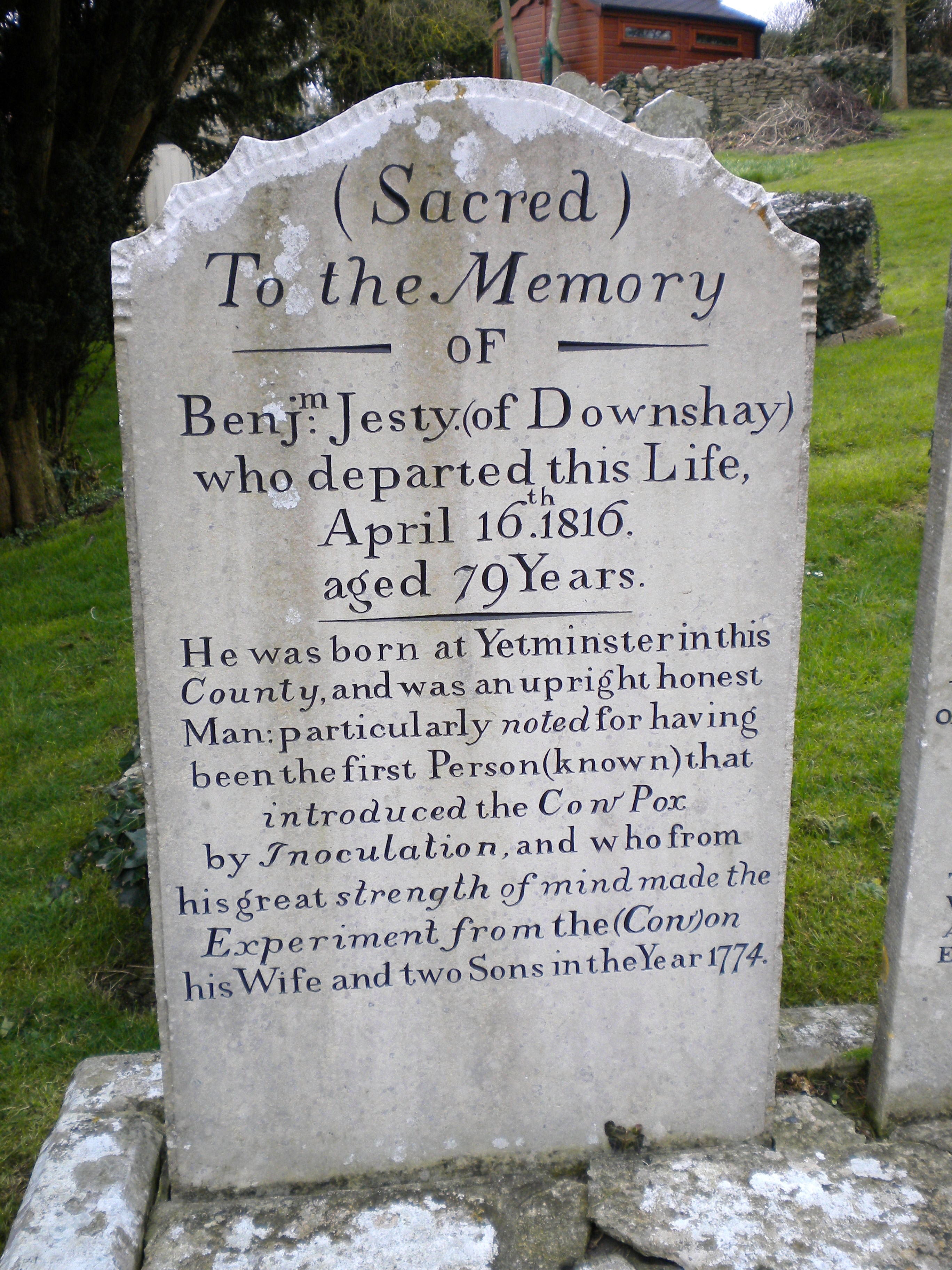
- The tombs of Benjamin Jesty, a farmer who is reported to have vaccinated his family against smallpox having made the same observations as Edward Jenner and a while earlier, but kept quiet about it, and his wife are side by side in the churchyard. Jesty's family may be the first recorded deliberate attempt to induce immunity to Smallpox using cowpox, or it may have been a more widespread activity prior to its systematisation.
- Sculptors Sir Anthony Caro (1924-2013) and Mary Spencer Watson (1913-2006) are buried in the village's churchyard.
- The first President of the Supreme Court of the United Kingdom Lord Phillips, took Worth Matravers as part of his title.
References
- OS Explorer Map OL15 – Purbeck & South Dorset. Ordnance Survey. 2006. ISBN 978-0-319-23865-3.
- "Purbeck Radar: Worth Matravers". Retrieved 30 March 2016.
- "Worth Matravers Parish Council | Home". Worth Matravers Parish Council. Retrieved 14 April 2022.
- "Area: Worth Matravers (Parish). Key Figures for 2011 Census: Key Statistics". Neighbourhood Statistics. Office for National Statistics. Retrieved 16 February 2015.
- "Worth Matravers – Dorset For You". Dorset For You Partnership. Retrieved 14 August 2007.
- "Parish Statistics" (PDF). Purbeck District Council. 11 January 2007. Archived from the original (PDF) on 27 September 2007. Retrieved 12 August 2007.
- Mare, Tess de La (28 March 2022). "National Trust acquires 7km stretch of Dorset coastline". Evening Standard. Retrieved 14 April 2022.
- "National Trust acquires Dorset 'speed-dating' caves for bats". the Guardian. 28 March 2022. Retrieved 14 April 2022.
- "National Trust brings coastal South Purbeck farm into its care". National Trust. Retrieved 14 April 2022.
- "Geograph:: ROC underground monitoring post, Worth... © Phil Champion cc-by-sa/2.0". www.geograph.org.uk. Retrieved 1 January 2021.
- "Winspit Quarry - a location from Destiny of the Daleks(DW), The Underwater Menace(DW)". The Locations Guide to Doctor Who, Torchwood, and the Sarah Jane Adventures. Retrieved 1 January 2021.
- "Blake's 7 - Winspit". www.hermit.org. Retrieved 1 January 2021.
- "PARISH CHURCH OF SAINT NICHOLAS, Worth Matravers - 1120262 | Historic England". historicengland.org.uk. Retrieved 17 November 2021.
- Historic England. "Bridge Inn, Topsham (1151928)". National Heritage List for England. Retrieved 19 August 2014.
- Brandwood, Geoff (2013). Britain's best real heritage pubs. St. Albans: CAMRA. pp. 36–37. ISBN 9781852493042.
External links
| Wikimedia Commons has media related to Worth Matravers. |
- Purbeck Radar Museum Trust website – early radar development at Worth Matravers 1940–1942
- Worth Matravers Parish Council
Towns, villages and hamlets in the Purbeck district of Dorset, England | ||
|---|---|---|
 |
| |
Authority control | |
|---|---|
| General |
|
| National libraries | |
На других языках
[de] Worth Matravers
Worth Matravers ist ein kleines Dorf und civil parish (Gemeinde) auf der Isle of Purbeck in der Grafschaft Dorset an der Südküste von England. Das Dorf ist Teil der Jurassic Coast, ein Weltnaturerbe.- [en] Worth Matravers
Другой контент может иметь иную лицензию. Перед использованием материалов сайта WikiSort.org внимательно изучите правила лицензирования конкретных элементов наполнения сайта.
WikiSort.org - проект по пересортировке и дополнению контента Википедии