world.wikisort.org - United_Kingdom
Woolfords is a small hamlet in the Parish of Carnwath, in South Lanarkshire, Scotland.
This article does not cite any sources. (May 2010) |
| Woolfords | |
|---|---|
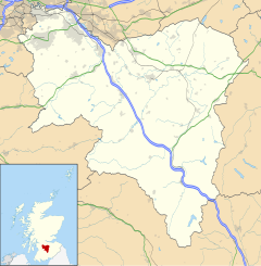 Woolfords Location within South Lanarkshire | |
| OS grid reference | NT003569 |
| Council area |
|
| Lieutenancy area |
|
| Country | Scotland |
| Sovereign state | United Kingdom |
| Post town | WEST CALDER |
| Postcode district | EH55 |
| Police | Scotland |
| Fire | Scottish |
| Ambulance | Scottish |
| UK Parliament |
|
| Scottish Parliament |
|
Woolfords is located on the road between Auchengray and West Calder, next to Cobbinshaw Reservoir. It was formerly part of West Calder in West Lothian and has an EH55 postcode.
Woolfords is at 1,000 feet (300 m) above sea level on the edge of the Pentland Hills. Nearby villages include Auchengray and Tarbrax.
North of Woolfords and the other side of the railway line is the linear settlement of Woolfords Cottages.
History
Woolfords was built to house the mineworkers for the coal, lime and shale mines of Cobbinshaw, Tarbrax and Baads Mill. Nearby Cobbinshaw is much older.
Transport
It once had its own railway station on the Caledonian Railway's Edinburgh to Carstairs Line. The station was located north of Auchengray railway station.
References
Settlements in South Lanarkshire | ||
|---|---|---|
| Towns |
|  |
| Villages and hamlets |
| |
List of places in South Lanarkshire | ||
This South Lanarkshire location article is a stub. You can help Wikipedia by expanding it. |
Другой контент может иметь иную лицензию. Перед использованием материалов сайта WikiSort.org внимательно изучите правила лицензирования конкретных элементов наполнения сайта.
WikiSort.org - проект по пересортировке и дополнению контента Википедии