world.wikisort.org - United_Kingdom
Wood Dalling is a village and civil parish in Norfolk, England. It is located 8 miles (13 km) south of Holt and 3 miles (4.8 km) north of Reepham, the nearest market towns.
| Wood Dalling | |
|---|---|
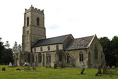
 St Andrew, Wood Dalling | |
 Wood Dalling Location within Norfolk | |
| Area | 9.89 km2 (3.82 sq mi) |
| Population | 209 (2011)[1] |
| • Density | 21/km2 (54/sq mi) |
| OS grid reference | TG089270 |
| Civil parish |
|
| District | |
| Shire county |
|
| Region |
|
| Country | England |
| Sovereign state | United Kingdom |
| Post town | NORWICH |
| Postcode district | NR11 |
| Police | Norfolk |
| Fire | Norfolk |
| Ambulance | East of England |
| UK Parliament |
|
The villages name means 'Dalla's people'. 'Wood' distinguish from Field Dalling.[2]
The civil parish has an area of 9.89 km2 (3.82 sq mi) and in the 2001 census had a population of 181 in 78 households, increasing to a population of 209 in 91 households at the 2011 census. For the purposes of local government, the parish falls within the district of Broadland.[3] The parish includes the hamlets of Norton Corner and Tyby.[citation needed]
The parish formed part of the hundred of Eynesford. Today, the parish forms part of the ward of Eynesford, which returns a councillor to Broadland District Council.[4]
Two places in the parish are mentioned in the Domesday Book — Dalling and Tyby.
Adjacent parishes include Guestwick, Heydon, Salle and Thurning.
There is a village hall, with part-time post office, at Norton Corner.[5]
There is a waymarked circular cycle trail along lanes around the parish and its immediate environs — the Wood Dalling Cycle Loop.[6]
Notes
- "Civil Parish population 2011". Neighbourhood Statistics. Office for National Statistics. Retrieved 15 August 2016.
- "Key to English Place-names".
- Office for National Statistics & Norfolk County Council (2001). Census population and household counts for unparished urban areas and all parishes Archived 2017-02-11 at the Wayback Machine. Retrieved 2 December 2005.
- Broadland District Council Polling districts, wards and parishes (2019)
- Wood Dalling Village Hall
- pages 21 and 22
External links
Другой контент может иметь иную лицензию. Перед использованием материалов сайта WikiSort.org внимательно изучите правила лицензирования конкретных элементов наполнения сайта.
WikiSort.org - проект по пересортировке и дополнению контента Википедии