world.wikisort.org - United_Kingdom
West Knoyle is a small village and civil parish in southwest Wiltshire, England, close to the southern edge of Salisbury Plain. The village is about 2.5 miles (4 km) east of Mere and 8 miles (13 km) south of Warminster. The A303 trunk road passes about 0.75 miles (1,210 m) north of the village.
| West Knoyle | |
|---|---|
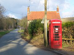
 Telephone box, West Knoyle | |
 West Knoyle Location within Wiltshire | |
| Population | 146 (in 2011)[1] |
| OS grid reference | ST858325 |
| Civil parish |
|
| Unitary authority |
|
| Ceremonial county | |
| Region | |
| Country | England |
| Sovereign state | United Kingdom |
| Post town | Warminster |
| Postcode district | BA12 |
| Dialling code | 01747 |
| Police | Wiltshire |
| Fire | Dorset and Wiltshire |
| Ambulance | South Western |
| UK Parliament |
|
| Website | West Knoyle |
History
A prehistoric bowl barrow, 8 m in diameter, lies on high ground northeast of the village.[2] A Romano-British pavement was found at Willoughby Hedge during widening of the A303.[3] The Domesday Book recorded 23 households at Chenvel in 1086, and land owned by Wilton Abbey.[4]
Wilton Abbey held the manor until the dissolution; later landowners include Christopher Willoughby (c.1508–1570), a Member of Parliament.[5]
Past names for the parish include Knoyle Hodierne or Odierne – after Hodierna of St Albans, wet nurse of Richard I of England, who had an estate at Chippenham[6] – and Little Knoyle.[7]
Manor Farmhouse, with 16th-century origins and altered in the 17th and 19th, may have material and fittings from the manor house which stood north of the church and was demolished in 1745.[8]
Parish church

The parish church of St Mary the Virgin, in the north of the present village, is a Grade II* listed building. It has 13th-century origins but was heavily restored in 1876–78, except for the 15th-century west tower.[9]
Four of the five bells are from the 17th century; they are said to be unringable and out of tune.[10]
The parish was a chapelry of North Newnton, over twenty miles to the northeast (another holding of Wilton Abbey),[11] until the two parishes were separated in 1841.[7] The benefice was united with Mere in 1929, and a curate was appointed to live at West Knoyle;[12] in 1976 Maiden Bradley was added to the united benefice, which continues today.[13][14]
Amenities
The Victorian former school is used as the village hall.[15]
The Monarch's Way long-distance footpath passes through the village. Hang Wood, to the southeast, is a biological Site of Special Scientific Interest.
References
- "Wiltshire Community History – Census". Wiltshire Council. Retrieved 17 June 2015.
- Historic England. "Bowl barrow 600m east of Manor Farm (1004756)". National Heritage List for England. Retrieved 14 November 2020.
- "Pavement, Willoughby Hedge". Wiltshire and Swindon Historic Environment Record. Wiltshire Council. Retrieved 14 November 2020.
- West Knoyle in the Domesday Book
- "Willoughby, Christopher (by 1508-70), of West Knoyle, Wilts". The History of Parliament. Retrieved 14 November 2020.
- Chronica magistri Rogeri de Houedene. Rolls Series. William Stubbs (ed.). London: Longmans, Green, Reader, and Dyer. 1869. p. xviii.
{{cite book}}: CS1 maint: others (link) - "No. 20021". The London Gazette. 24 September 1841. pp. 2369–2370.
- Historic England. "Manor Farmhouse (1318477)". National Heritage List for England. Retrieved 14 November 2020.
- Historic England. "Church of St Mary the Virgin (1199597)". National Heritage List for England. Retrieved 14 November 2020.
- "West Knoyle". Dove's Guide for Church Bell Ringers. Retrieved 23 September 2020.
- Baggs, A.P.; Crowley, D.A.; Pugh, Ralph B.; Stevenson, Janet H.; Tomlinson, Margaret (1975). Crittall, Elizabeth (ed.). "Victoria County History: Wiltshire: Vol 10 pp126-136 – Parishes: North Newnton". British History Online. University of London. Retrieved 14 November 2020.
- "No. 33507". The London Gazette. 18 June 1929. pp. 4022–4024.
- "No. 46878". The London Gazette. 20 April 1976. p. 5681.
- "West Knoyle: St Mary the Virgin". A Church Near You. Church of England. Retrieved 14 November 2020.
- "The Village Hall". westknoyle.org. Retrieved 14 November 2020.
External links
- "West Knoyle village site". Retrieved 17 June 2015.
![]() Media related to West Knoyle at Wikimedia Commons
Media related to West Knoyle at Wikimedia Commons
Другой контент может иметь иную лицензию. Перед использованием материалов сайта WikiSort.org внимательно изучите правила лицензирования конкретных элементов наполнения сайта.
WikiSort.org - проект по пересортировке и дополнению контента Википедии