world.wikisort.org - United_Kingdom
Upton is a village and civil parish in the Peterborough district, in the ceremonial county of Cambridgeshire, England.[1] For electoral purposes it forms part of Glinton and Wittering ward in North West Cambridgeshire constituency.[2] The population of the parish is included in the civil parish of Sutton.
| Upton | |
|---|---|
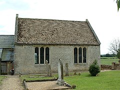
 St John the Baptist, Upton | |
 Upton Location within Cambridgeshire | |
| OS grid reference | TF 107 005 |
| Unitary authority |
|
| Ceremonial county | |
| Region |
|
| Country | England |
| Sovereign state | United Kingdom |
| Post town | Peterborough |
| Postcode district | PE6 |
| Police | Cambridgeshire |
| Fire | Cambridgeshire |
| Ambulance | East of England |
| UK Parliament |
|
The Parish Church of St John the Baptist is a 12th-century Norman church with a north aisle rebuilt in 17th century. It was a chapel-of-ease and was built as a daughter church to St Kyneburgha's at Castor. The church is a Grade I listed building.[3] It is set in the fields to the east of the village, 100 yards from the Roman King Street.
References
- Ordnance Survey: Landranger map sheet 142 Peterborough (Market Deeping & Chatteris) (Map). Ordnance Survey. 2012. ISBN 9780319229248.
- "Ordnance Survey Election Maps". www.ordnancesurvey.co.uk. Ordnance Survey. Retrieved 3 April 2016.
- Historic England. "Details from listed building database (1127440)". National Heritage List for England. Retrieved 20 April 2016.
External links
![]() Media related to Upton, Peterborough at Wikimedia Commons
Media related to Upton, Peterborough at Wikimedia Commons
Текст в блоке "Читать" взят с сайта "Википедия" и доступен по лицензии Creative Commons Attribution-ShareAlike; в отдельных случаях могут действовать дополнительные условия.
Другой контент может иметь иную лицензию. Перед использованием материалов сайта WikiSort.org внимательно изучите правила лицензирования конкретных элементов наполнения сайта.
Другой контент может иметь иную лицензию. Перед использованием материалов сайта WikiSort.org внимательно изучите правила лицензирования конкретных элементов наполнения сайта.
2019-2025
WikiSort.org - проект по пересортировке и дополнению контента Википедии
WikiSort.org - проект по пересортировке и дополнению контента Википедии