world.wikisort.org - United_Kingdom
Sough /sʌf/ is a hamlet, in Lancashire, England.
This article does not cite any sources. (April 2018) |
| Sough | |
|---|---|
 The A56 road | |
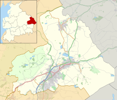 Sough Location in Pendle Borough  Sough Location within Lancashire | |
| OS grid reference | SD902454 |
| Civil parish |
|
| District |
|
| Shire county |
|
| Region |
|
| Country | England |
| Sovereign state | United Kingdom |
| Post town | BARNOLDSWICK |
| Postcode district | BB18 |
| Dialling code | 01282 |
| Police | Lancashire |
| Fire | Lancashire |
| Ambulance | North West |
| UK Parliament |
|
Sough is located east of the main A56 road between Earby and Kelbrook; it is in the area known as West Craven in the district of Pendle.
This area used to be part of Earby Urban District in the West Riding of Yorkshire until boundary changes in 1974.
See also
- Kelbrook and Sough
![]() Media related to Sough, Lancashire at Wikimedia Commons
Media related to Sough, Lancashire at Wikimedia Commons
- Listed buildings in Kelbrook and Sough
This Lancashire location article is a stub. You can help Wikipedia by expanding it. |
Текст в блоке "Читать" взят с сайта "Википедия" и доступен по лицензии Creative Commons Attribution-ShareAlike; в отдельных случаях могут действовать дополнительные условия.
Другой контент может иметь иную лицензию. Перед использованием материалов сайта WikiSort.org внимательно изучите правила лицензирования конкретных элементов наполнения сайта.
Другой контент может иметь иную лицензию. Перед использованием материалов сайта WikiSort.org внимательно изучите правила лицензирования конкретных элементов наполнения сайта.
2019-2025
WikiSort.org - проект по пересортировке и дополнению контента Википедии
WikiSort.org - проект по пересортировке и дополнению контента Википедии