world.wikisort.org - United_Kingdom
Sidlow is a mainly rural, lightly populated village in the parish of Salfords and Sidlow, in the south of the borough of Reigate and Banstead in Surrey, England.
| Sidlow | |
|---|---|
| Village | |
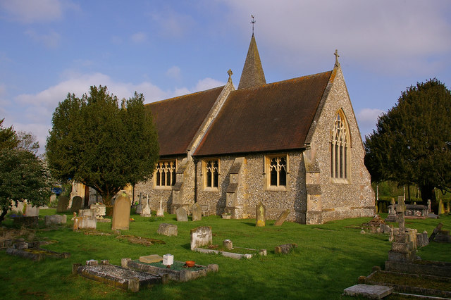 Emmanuel Church | |
 Sidlow Location within Surrey | |
| Area | 11.93 km2 (4.61 sq mi) |
| Population | 636 (2011 census)[1] |
| • Density | 53/km2 (140/sq mi) |
| OS grid reference | TQ259470 |
| Civil parish |
|
| District | |
| Shire county | |
| Region | |
| Country | England |
| Sovereign state | United Kingdom |
| Post town | REIGATE |
| Postcode district | RH2 |
| Dialling code | 01737 |
| Police | Surrey |
| Fire | Surrey |
| Ambulance | South East Coast |
| UK Parliament | |
Geography and sublocalities
Sidlow is the west of the civil parish; a high proportion of its land is taken up by farms; no motorways or railways bisect this part of the parish instead the area has three small tributaries' confluences with the upper River Mole. Urban to suburban development is residential and concentred into a linear settlement along a lane west of a road junction with the north-south A217 road which has the Anglican church opposite. Beyond this the road forms a crescent which briefly becomes urban again at the Ironsbottom neighbourhood, a sub-settlement. Two lines of further development are towards the crescent return of the lane named Ironsbottom at Wrays and south along the A217 at Crutchfield. The A217 direct, traffic light-controlled route between the economic centres of Reigate and Gatwick Airport is bypassed for long-distance traffic by the M23 motorway 3 miles (4.8 km) east. Less than 5% of the land of Sidlow is at flood risk, in built terms, restricted to homes opposite the church of Sidlow Bridge and the church itself.[2]
Church
Sidlow has a Church of England church, the Emmanuel Church at Sidlow Bridge, dating to 1861. The church was designed by Henry Clutton with stained glass by Henry Holiday.[3] It is in the medieval-founded Diocese of Southwark. The lych gate to the church was erected in 1921 as a memorial to the village's war dead from the Great War. It is Grade II listed.[4]
Duxhurst Industrial Farm Colony
Duxhurst Industrial Farm Colony, a voluntary in-patient residential treatment center for the treatment and cure of habitual alcoholic women was founded in 1895 at Duxhurst, about 4 miles (6.4 km) from Reigate railway station,[5] by Lady Henry Somerset.[6] The 180 acres (73 ha) farm contained home-like cottages, a church, the chaplain's lodge, farm buildings, a hospital, and a large dining and recreation hall.[7]
References
- Key Statistics: Population Density: Population and Area. Output Areas E00156202 and E00156205: 307 in 6.78 square km and 329 in 5.15, includes a small part ecclesiastically of Salfords an eastern area however associated with Sidlow and with Salfords physically and administratively. Retrieved 2015-02-27.
- Flood Risk Map of surrounding areas of 'Sidlow' - showing Riparian risk levels Archived 2015-04-18 at the Wayback Machine Environment Agency. Accessed 2015-04-15.
- "Our History". Emmanuel Church. Retrieved 10 January 2022.
- Historic England (18 September 2018). "War Memorial Lych Gate, Emmanuel Church, Sidlow (Grade II) (1459067)". National Heritage List for England.
- "DUXHURST FARM COLONY FOR INEBRIATES". British Medical Journal. British Medical Association. 1: 483. 1897. Retrieved 20 August 2022.
 This article incorporates text from this source, which is in the public domain.
 - Cherrington, Ernest Hurst (1926). Standard Encyclopedia of the Alcohol Problem. Vol. 3. American Issue Publishing Company. p. 868. Retrieved 20 August 2022 – via Internet Archive. This article incorporates text from this source, which is in the public domain.
- Whitaker, Joseph (1911). "The Industrial Fram Village, Duxhurst, Reigate.". An Almanack... London: Whitaker's Almanack. p. 690. Retrieved 21 August 2022. This article incorporates text from this source, which is in the public domain.
External links
Neighbouring areas of Surrey | |
|---|---|
| Towns, villages, neighbourhoods and hamlets |
|  | ||||||||||||||
|---|---|---|---|---|---|---|---|---|---|---|---|---|---|---|---|---|
| Most notable parks |
| |||||||||||||||
| Places of worship |
| |||||||||||||||
| Education |
| |||||||||||||||
| Transport |
| |||||||||||||||
| Buildings and structures |
| |||||||||||||||
| Sport | ||||||||||||||||
| Politics and Administration |
| |||||||||||||||
Places listed are articles notable as settlements, arranged by post town The two principal towns are emboldened The M23 motorway follows approximately a boundary and is chiefly included for its regional importance. | ||||||||||||||||
Другой контент может иметь иную лицензию. Перед использованием материалов сайта WikiSort.org внимательно изучите правила лицензирования конкретных элементов наполнения сайта.
WikiSort.org - проект по пересортировке и дополнению контента Википедии