world.wikisort.org - United_Kingdom
Molesey is a district of two twin towns, East Molesey and West Molesey, in the Borough of Elmbridge, Surrey, England, and is situated on the south bank of the River Thames.
This article uses bare URLs, which are uninformative and vulnerable to link rot. (September 2022) |
| Molesey | |
|---|---|
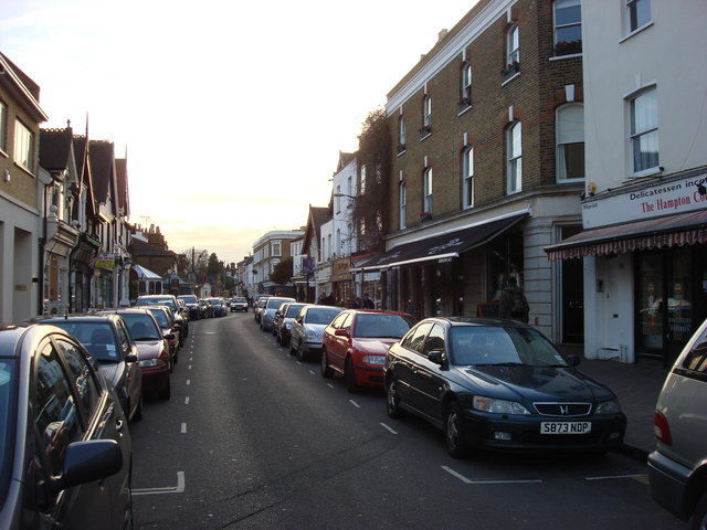 Bridge Road, East Molesey | |
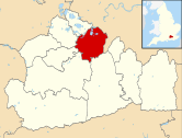
 Molesey Location within Surrey | |
| Area | 5.87 km2 (2.27 sq mi) |
| Population | 19,088 (2011 census)[1] |
| • Density | 3,252/km2 (8,420/sq mi) |
| OS grid reference | TQ145675 |
| • Charing Cross | 12 mi (19 km) NE |
| Civil parish |
|
| District | |
| Shire county | |
| Region | |
| Country | England |
| Sovereign state | United Kingdom |
| Post town | EAST MOLESEY WEST MOLESEY |
| Postcode district | KT8 |
| Dialling code | 020 |
| Police | Surrey |
| Fire | Surrey |
| Ambulance | South East Coast |
| UK Parliament |
|
East and West Molesey share a high street, and there is a second retail restaurant-lined street (Bridge Road) close to Hampton Court Palace in the eastern part of the district, which is also home to Hampton Court railway station in Transport for London's Zone 6. Molesey Hurst or Hurst Park is a large park by the River Thames in the north of the area, and is home to East Molesey Cricket Club. The Hampton Ferry runs from here to Hampton on the Middlesex bank, from where it is a short walk to the central area of Hampton.
Molesey is divided into three wards: Molesey South, East and North. The majority of Molesey's detached properties are in the east, which also contains the highest proportion of apartments of the three wards. Molesey forms part of the Greater London Built-up Area.[2]
History
This section needs expansion. You can help by adding to it. (January 2011) |
The earliest documentary evidence of a settlement in Molesey appears in a 7th-century charter, shortly after Erkenwald founded Chertsey Abbey in AD 666. He secured from Frithwald, sub-king of Surrey, a charter endowing the abbey with much of the surrounding land, including Muleseg. Etymologists suggest that the town's name is derived from the personal name Mul (pronounced Mule) compounded with the Old English word eg, meaning an island or river meadow – thus Mul's Island. Therefore, Molesey is not, as commonly believed, named after the River Mole that runs through it. The prefixes East and West did not appear until about the year 1200, before which there was only one parish centred around what is now known as East Molesey.[3] Molesey lay within the Saxon administrative district of Elmbridge hundred.
East Molesey appears in Domesday Book of 1086 as Molesham. It was held partly by John from Richard Fitz Gilbert and partly by Roger d'Abernon. Its Domesday assets were: 2 hides and 3 virgates. It had 7 ploughs, 2 oxen, and 32 acres (13 ha) of meadow and woodland worth 10 hogs. It rendered £6 15s 0d. West Molesey was held by Odard Balistarius. Its Domesday assets were: 1 hide, 1 church, and 5 ploughs. It rendered £4.[4]
Along with neighbouring Thames Ditton, East Molesey formed a part of the ancient parish of Kingston upon Thames, based at the historic All Saints Church, Kingston upon Thames. From 1933, the Urban District of East and West Molesey became part of the Esher Urban District, which was originally recommended by the Royal Commission on Local Government in Greater London (the Herbert Commission) for inclusion within the new ceremonial county of Greater London. In 1974, the district eventually merged with its neighbour to the west, Walton and Weybridge Urban District, to form the new borough of Elmbridge within Surrey.[5]
Molesey was one of the many villages and towns along the Thames valley affected by flooding in 1968; specifically here the flooding of the River Mole. Some barriers and overflow fields have been created since then by the Environment Agency and its precursors.[6]
East and West Molesey uses a roughly due north–south compass axis, based on a point of division by the Molesey Stone on the grass outside Molesey Library on Walton Road, though the Stone has been moved from its original position and the actual boundary between East and West Molesey has become somewhat blurred and disputed. East Molesey and other parts of Elmbridge have some of the most expensive postal codes in Surrey while West Molesey has some of the cheapest.
Locality

Molesey is directly south of the River Thames, with several large reservoirs bordering the town to the west and south that provide water within the London Basin. Some of these are now disused and are being converted into nature reserves. To the west lie Bessborough Reservoir and Knight Reservoir, to the north-west Molesey Reservoirs, to the south Island Barn Reservoir, and to the south-west Queen Elizabeth II Reservoir. There are walks beside Metropolitan green belt fields to the south along the river Mole to Esher, and to the west along the Thames Path to Walton-on-Thames.
Hampton Court Palace is immediately north-east of East Molesey across Hampton Court Bridge.

The Palace, together with the southern part of Bushy Park and most of Hampton Court Park are in the post town East Molesey.
Molesey Lock is just above Hampton Court Bridge, downstream of Sunbury Lock and upstream of Teddington Lock. Cigarette Island Park is just below the bridge, occupying the eastern extremity of the town.
Hurst Park is on the south bank of the Thames, from where there is a daily ferry service to Hampton on the Middlesex bank. It once had a horse racing course but no longer does.
The residential streets of East Molesey run directly into Weston Green and the northernmost stretches of residential Esher to the south, and Thames Ditton to the south-east. Together with the reservoirs, Green Belt land to the west and south-west divides West Molesey from Walton on Thames.
On the south side of Molesey, separating West Molesey from Hersham and Walton-on-Thames, lies Molesey Heath which is home to a large and rapidly growing roost of Parakeets, one of several in North Surrey. Thousands of these bright green birds can be seen flying across the heath in the hour before sunset each day as they return to their roosts on the heath and at nearby Esher Rugby Club.
The central shopping area of Kingston upon Thames lies 1.7 miles east of Bridge Road in East Molesey, while central Walton on Thames lies 2.3 miles to the west-southwest of West Molesey High Street.
Landmarks
Molesey itself has some interesting landmarks, including three listed Church of England churches and The Bell, a public house, formerly known as "The Crooked House", built in the mid-15th century. Other Landmarks include The Jubilee Fountain in Bridge Road. There are three designated Conservation Areas in East Molesey.
Other historic buildings include the Grade II-listed Matham Manor, an altered 15th-century house with timber frames and red brick; and a 16th-century house, Quillets Royal, with an 18th-century extension (The Manor House). Both buildings lie near The Bell in Bell Road/Matham Road.[7]
In April 2017, 15th Century St Peter's church on Walton Road, said to be the oldest building in Molesey, had lead stolen from the roof and historic masonry damaged in a nighttime theft. Thieves used scaffolding put up to install an antenna approved by Elmbridge Council. Press reports at the time alleged that police had been alerted to the crime by a local resident but that they had declined to attend.[8]
Bars, public houses and restaurants
Molesey has many traditional pubs and restaurants, though several public houses have closed in recent years to become apartment buildings. They have largely consolidated on a few with successful niche products or music offerings such as The Poyntz Arms with live music on Friday evenings. Molesey's modern bars are composed of Signature Cafe Lounge and Bar, the Square Olive and the Prince of Wales in East Molesey.
Molesey East & West Conservative Club and the Royal British Legion Club are the only members' clubs (both in East Molesey).
The remaining pubs in West Molesey are The Cannon and The Royal Oak.
As of 2015, there are Chinese, Indian, French, Italian, Greek, Nepalese and Lebanese restaurants in the area, as well as branches of Pizza Express and Zizzi.
Scout groups
Molesey has three Scout groups which all belong to Esher District. 1st Molesey is a Royal Navy-recognised Sea Scout group whilst 2nd and 3rd Molesey are both Land Scout Groups. All groups have sections from Beavers right through to Explorers. The groups take part in a wide variety of activities and events throughout the year at various locations.
River channels, flooding and speculative building
This section does not cite any sources. (March 2019) |
Molesey's conservation area is to the south by a corollary channel of the River Mole, known as the River Ember, where successive environment authorities have implemented capacity-adding flood defences following a widespread and costly flood in 1968. Following further extensive flooding along the Thames in 2014 the Environment Agency is to carry out more large scale 'capacity building' work involving the construction of nine miles of new channels in areas upstream of Molesey as part of a flood relief project known as the River Thames Scheme (RTS) running between 2018 and 2027.
Before 1968 the whole area including expensive areas such as East Molesey flooded badly on a regular basis as they are in part located on the former flood plains of the Thames and the Mole. Even today localised flooding and standing water can be quite common in times of heavy rain as the area is very low lying and flat. Molesey can be the subject of flood warnings that affect the Thames Valley.
Molesey Lock is the second lock (and weir) on the River Thames, and marks the furthest point upstream that the influence of the tides on the Thames (regulated by the Thames Barrier at Woolwich) may be registered. The lock is located within 100 metres of Hampton Court Bridge, designed by Edwardian Arts and Crafts architect Edwin Lutyens, styles reflected by contemporary properties in the town. Other styles which are prevalent are 1960s red-brick semi-detached homes and Art Deco/Bauhaus.
In the West Molesey area some houses are the result of over-optimistic development in the 1930s by developer Donald Gordon Howard who eventually went bankrupt trying to sell houses at exceptionally low prices – at £395 some of the cheapest in the London area – while implying a misleading proximity to Hampton Court. The attraction was cheap, low-lying land near the London reservoirs and quite remote from transport links, especially the railway. Speculative land dealing and building go back a long way in the area. Much of East Molesey resulted from large scale land speculation in the 1850s by Francis Jackson Kent who saw an opportunity to make a fortune when the railway arrived at Hampton Court in 1849, quickly buying up land nearby and selling it on to wealthy individuals or developers who rapidly built on low lying former meadows that had always been flood prone. They naturally remained so until the 1960s when the nearby River Mole was re channeled after a hugely expensive flood. Pictures of the East Molesey area and Hampton Court station environs (on the opposite bank to the Palace) in flood conditions recur in 19th and 20th centuries.
Molesey and adjacent areas of Esher, Walton and Hersham also have a significant amount of former council housing constructed by the predecessors to Elmbridge Council. There are also areas of post-war system built housing, thought[by whom?] to be of the concrete sectional type, built at the time of housing shortage in the years after World War 2 including on the West Molesey/East Molesey border. It was at one time home to the well-known company Roberts Radio who built a factory there in 1962.
Women's suffrage
This section possibly contains original research. (October 2021) |
The former Hurst Park race course in Molesey was the scene of an event of the suffragette campaign when two women extremists set fire to the grandstand in 1913 virtually destroying it in a huge and costly blaze that could be seen across large parts of south London, requiring fire crews from many surrounding areas to extinguish it. The attack was said to be in revenge for the death of Emily Davison at the Derby earlier that year and part of a deliberately violent and destructive campaign by the suffragette movement that in turn provoked an increasingly harsh crackdown by politicians, police and judiciary with more arrests and imprisonments and a raid on the suffragette HQ by police. There had already been large deployments of police to protect politicians and break up suffragette demonstrations and numerous complaints about the aggressive tactics of the police and 'roughs' or thugs who seemed to be allowed to attack and assault the demonstrators. Suffragette fury built over time but especially in 1910 when the Government promised a bill giving some women the vote but this was talked out in a cynical and devious political move resulting in a mass demonstration by women to Parliament on 'Black Friday' 1910.[citation needed]
It had seemed that the system was on the side of justice and reason in a case of clear injustice but this now appeared a molesham. Violence erupted and police arrested over 100 women but once again there were many complaints about police actions and their apparent 'blind eye' or even encouragement of harassment and assaults by thugs and yobs.[citation needed] The Government tried to suppress the Daily Mirror which appeared to show a policeman and yobs kicking an apparently well-off middle-class women on the ground on the front page. One of the women in the Molesey attack, Kitty Marion, had already been in prison for breaking windows and causing disturbances at speeches by prominent politicians and had staged violent hunger strikes while in prison but had been brutally force fed on several hundred occasions. However, an interview in the "BBC History" Magazine in May 2018 describes the violence of the suffragettes revealing the extent of their bombing and arson campaign – Marion herself is said to have carried out a "nationwide" arson and bombing campaign while in May 1913 alone suffragettes carried out 52 attacks the "majority" involving bombs and arson while a loaded revolver, shotgun and prepared bomb were found in a raid on another woman's home. Nitroglycerin and phosphorus bombs were also used the latter causing serious injuries. Author and historian Fern Riddell labels the suffragettes of the WSPU as "terrorists".[9] The police regarded the women extremists as more dangerous than Irish and anarchist terrorists and "the most dangerous organisation operating in Britain at that time" according to the interview.
Sports
Molesey was once the bare-knuckle boxing centre of England,[10] and had a famous horse-racing track stretching the length of the River Thames from where Hurst Park School now stands, down to Molesey Lock. Much of the course was built on in the 1960s: the Hurst Park Estate has a mixture of three and two-storey homes and a block of flats overlooking the river. Part of the open space that was part of the racetrack is now an riverside park. There is a wide grass expanse, a playground and open access to the Thames, features here include the popular Hampton Ferry and Molesey Regatta, a major event in the sport of rowing with catering and evening outdoor music. There are some large iron gates in the access road to Hurst Park called Graburn Way which were built so that horse races then started just east of the road and enabled the course to have a 'straight mile'.
Cricket
This section does not cite any sources. (March 2019) |
'Moulsey Hurst' is a very early site of cricket (from 1731) and that tradition is continued to this day by East Molesey Cricket Club, which is located alongside the South bank of the Thames, half a mile from Hampton Court Palace. It was founded in 1871. The club's first XI play in Surrey Championship Premier Division and there are three other senior Saturday league sides and one senior Sunday league side, regularly competing against other Surrey clubs. The club continues to place special emphasis on generating a love of cricket amongst Molesey's junior residents. The first recorded Leg Before Wicket (LBW) dismissal in first class cricket is said to have been given in a game between an XI of Surrey and a XIII of England at this site in 1795. Prior to this date there had been several attempts to formulate a law that would stop batsmen simply obstructing their wicket with their leg pads to prevent being bowled. The LBW law has been revised several times since then.
Rowing
Molesey Boat Club (established 1866) is home to some current Olympic and World Championship medallists and domestic success at all ages, particularly in its adult crews. The rowing club also competes in the Amateur Molesey Regatta held annually in Hurst Park[11]
Football
Molesey F.C. is a non-league football team based in West Molesey. The club is currently a member of the Isthmian League and play at the Herds Renault Stadium, Walton Road. The original football club was established by former Corinthian player James Jenkinson Knox in Autumn 1892 under the name Hampton Court and East Molesey Association Football Club. Their first match was played on 24 September 1892 against Barnes, winning 14–5. In 1946 Molesey United and West Molesey Old Boys merged to form Molesey Football Club. The new club joined the Surrey Intermediate League and won the league in their first season.
Metropolitan Police F.C. is a non-league football team based in East Molesey and are based at the Imber Court Sports Ground.
AFC Molesey is a former non-league football team that was also based in West Molesey, a member of the Surrey County Intermediate League (Western) Division One and played at the West Molesey Recreation Ground, Walton Road. Up to the date that the club folded, the club had seen its popularity grown significantly following its winning several honours including the Lower Junior County Cup in the 2007/08 season and successful consecutive league promotions.
Molesey Juniors F.C. is a community youth football organisation based at the Wilderness Playing Fields, East Molesey
Swimming
Just beyond the gates of Hurst Park used to be the home of the open air Upper Deck swimming pool, the nearest open air pool now being across the ferry up Hampton High Street in Hampton. An indoor pool was built by the council nearby as a replacement. Upmarket flats are now built on the site of the outdoor pool. The entire riverside recreational area was previously referred to as Moulsey Hurst. Hurst swimming pool is in Dunstall Way in the north of Molesey.
Pool/Billiards
The Poyntz Arms Public House and Molesey East & West Conservative Club host matches in the Tolworth and District Pool League.
Darts
Darts is a very popular sport in Molesey, played at several public houses including the Molesey Football Club, The Royal Oak, The Cannon and the Royal British Legion. Teams are made up of patrons and club members. All teams compete in the Molesey and District Darts League.
Cycling
In 2012 Bradley Wiggins won the Olympic Time Trial event. The course passed through East and West Molesey and Hurst Park, and the event finish was at Hampton Court Palace, which has an East Molesey postcode: Hampton Court Palace, East Molesey, Surrey KT8 9AU.
The Surrey Classic Cycle race passes East and West Molesey and Hurst Park yearly.
National Cycle Network route #4 passes along the River Thames towpath through Molesey.
Crime
A website that collates various police statistics for locations across the country reports that for the period September 2016 to August 2017 Violent Crime was the biggest single category of offences for the West Molesey area with 241 instances shown. According this data Violent Crime comfortably exceeded the second category which was Anti-Social Behaviour with 224 instances.[12] Criminal Damage and Arson ranked third with 104 instances and Burglary fourth with 82 instances. Home Office Statistics for the next chronological period (August 2017 to July 2018) are very similar showing Violence and Sexual offences as the largest category with 248 offences, Anti-Social Behaviour second with 198 offences and Burglary third with 106 offences just ahead of Criminal Damage and Arson with 101 offences[13]
There were two murders in West Molesey in 2016–17. A woman was found murdered with a machete or axe according to police in the front garden of her house on Walton Road, Molesey in March 2016 resulting in extensive national publicity.[citation needed] Police launched a second current local murder investigation on 7 December 2017 when a woman reported as previously deliberately run down in the small hours of the morning in a car park on land between Hurst Road, Molesham Way and Walton Road, died in hospital.[citation needed] A man was also murdered while fishing on the Thames towpath in nearby Walton in 2016. Three young men with links to Molesey or other nearby areas were jailed for this crime in early 2019.[citation needed]. A young man from Molesham Way was also jailed for five years in 2020 after a hammer attack on a young woman in Guildford in 2019.
Transport
Rail service
The railway station in East Molesey is Hampton Court railway station in Transport for London's Zone 6, operated by South Western Railway. This is the terminus of a stopping commuter service to London Waterloo that takes around thirty-five minutes. Principal stops are Surbiton, Wimbledon and Clapham Junction. During the Hampton Court Palace Flower Show extra trains run to and from London.
Bus services
Four bus routes serve the town.
- To the east
Transport for London's London Buses route 411 (previously the route 131 from West Molesey to Kingston), is operated by London United. The short route begins at Central Avenue in West Molesey and runs through East Molesey, past Hampton Court Station and on to Kingston town centre.[14]
- To the north-east
East Molesey's northern point by its station, shopping parade and small riverside park is the terminus of a second Transport for London bus service, route R68, operated by Abellio London. The route begins at Hampton Court station, and runs through Hampton, Hampton Hill, Teddington, Strawberry Hill, Twickenham and Richmond before ending at Kew retail park.[15]
- To the west
Route 461, operated by Falcon Coaches on behalf of Surrey County Council, runs from Kingston, through Molesey and on to Walton, terminating at Tesco, Addlestone.
- To the south-west and south-east
Route 514, also operated by Falcon on behalf of Surrey County Council, runs from Hersham to Kingston via Molesey, Thames Ditton, Long Ditton and Surbiton.
Neighbouring Settlements of Surrey and Greater London | ||||||||||||||||
|---|---|---|---|---|---|---|---|---|---|---|---|---|---|---|---|---|
| ||||||||||||||||
Notable residents
This section needs additional citations for verification. (October 2021) |
- Rick Astley, British pop musician, lives in East Molesey.[16]
- Chemmy Alcott, British Olympic alpine skier
- Mick Avory, drummer and percussionist for rock band The Kinks, grew up in West Molesey.[17]
- Keith Barron, actor, lived in the town from the 1970s to 2017.
- Ed Bishop, actor, lived in West Molesey.
- Liv Boeree, professional poker player, lives in East Molesey
- Ronald Brooks (1899–1980), first-class cricketer and British Army officer
- Cottie Arthur Burland (1905–1983), head of ethnography at British Museum
- Bernie Constable (1921–1997), cricketer, brother of the below
- Dennis Constable (1925–2011), cricketer, brother of the above
- Bill Cotton, the television producer and executive and the son of big-band leader Billy Cotton, lived in East Molesey in his latter years.
- Terence Cuneo (1907–1996), artist.
- Hazell Dean, pop music singer, lives in the town.
- Bob Falconer ( born 1962), of East Molesey, a former English cricketer
- Kenneth Falconer, mathematician, resident in the 1960s.
- Ray Galton comedy dramatist. Most notable for Hancock's Half Hour and Steptoe and Son.
- Marius Goring, actor
- Herbert "Barry" Hart (1894–1954), Sculptor and stone carver, died at 2 Walton Road, East Molesey.[18]
- Roy Holder, actor
- Jentina, British rapper
- Eric Lyons, architect
- Lee Mack, stand-up comic, lives in East Molesey
- Howard Parkes (1877–1920), cricketer, buried at Molesey Cemetery, West Molesey.[19]
- John Orlando Parry (1810–1879), 19th century entertainer.[20]
- Daniel Pemberton, musician
- Luke Shaw, professional footballer, grew up in West Molesey[21] and played for Molesey Juniors FC.
- Alfred Sisley (1839–1899), Anglo-French impressionist painter, resided in East Molesey in 1874, executing nearly twenty paintings of the Upper Thames.
- Steve Steen, actor, lives in East Molesey.
- Les Strong, professional footballer who played for Crystal Palace and Fulham
- Edward A Sydenham (1873-1948), vicar of West Molesey, and numismatist specialising in Roman coins
- Michael Underwood, the physician who first described polio, was born in West Molesey.
- Julius Vogel (1835–1899), Prime Minister of New Zealand, resident in East Molesey in his final years.
- Matt Willis, the musician, TV presenter and ex-actor, who is best known for being the bassist in Busted, lived in Molesey during his youth.
- Freya Wilson, actress.
Demography and housing
| Output area | Detached | Semi-detached | Terraced | Flats and apartments | Caravans/temporary/mobile homes | Shared between households[1] |
|---|---|---|---|---|---|---|
| East (ward) | 909 | 677 | 334 | 753 | 1 | 11 |
| North (ward) | 454 | 879 | 818 | 358 | 0 | 0 |
| South (ward) | 247 | 1,113 | 867 | 595 | 0 | 2 |
The average level of accommodation in the region composed of detached houses was 28%, the average that was apartments was 22.6%.
| Output area | Population | Households | % Owned outright | % Owned with a loan | hectares[1] |
|---|---|---|---|---|---|
| East (ward) | 6,337 | 2,685 | 38 | 40 | 298 |
| North (ward) | 6,008 | 2,509 | 37 | 41 | 164 |
| South (ward) | 6,743 | 2,824 | 27 | 41 | 125 |
The proportion of households in the settlement who owned their home outright compares to the regional average of 35.1%. The proportion who owned their home with a loan compares to the regional average of 32.5%. The remaining % is made up of rented dwellings (plus a negligible % of households living rent-free).
There is a locally moored boat, the West Molesey houseboat, which is moored on the river Thames.
References
- Key Statistics; Quick Statistics: Population Density United Kingdom Census 2011 Office for National Statistics Retrieved 21 November 2013
- UK Census (2011). "Local Area Report – Greater London Built-up area (E34004707)". Nomis. Office for National Statistics. Retrieved 9 March 2022.
- The Book of Molesey by Rowland G M Baker
- Surrey Domesday Book Archived 15 July 2007 at the Wayback Machine
- "History of Elmbridge Borough Council". Archived from the original on 23 December 2010. Retrieved 21 April 2010.
- http://www.environment-agency.gov.uk Flood Prevention Scheme Map. Retrieved 10 April 2012.
- The Heritage List for England online. Retrieved 10 April 2012
- Get Surrey 6 April 2017
- BBC History Magazine. May 2018
- Baker, Rowland (1989). Thameside Molesey. U.K. ISBN 978086023-414-2. extracts available here
- Molesey Boat Club website medal results 2011–2012. Retrieved 10 April 2012
- UKCrimeStats.com
- http://www.police.uk/surrey/ELWM/crime/stats/
- Route 411 Transport for London
- Route R68 Transport for London
- Interview with Rick Astley, ' The Times', 21 October 2018. https://www.thetimes.co.uk/article/rick-astley-interview-the-1980s-pop-star-on-diy-disasters-and-why-hes-never-gonna-get-into-gardening-vh7ccb32v
- in Balmoral Crescent
- "(Herbert) Barry Hart". Mapping the Practice and Profession of Sculpture in Britain and Ireland 1851-1951, University of Glasgow History of Art and HATII, online database 2011. Retrieved 4 June 2021.
{{cite web}}: CS1 maint: url-status (link) - Entry in Commonwealth war Graves Commission online website for the grave of Howard Roderick Parkes. https://www.cwgc.org/find-war-dead/casualty/75229201/parkes,-howard-roderick/
- Reference to John Orlando Parry, 'Oxford Index' website, Oxford University Press (2020). https://oxfordindex.oup.com/view/10.1093/oi/authority.20110803100307865
- "Shaw Savouring Chelsea Contest". Southampton F.C. Archived from the original on 12 October 2013. Retrieved 17 August 2013.
External links
- Molesey History – This site has many books, papers and pictures on the history of Molesey and the surrounding area from Rowland G M Baker's collection.
- Molesey News & Mail local newspaper
- Molesey Residents' Association – The local Residents Association.
- Elmbridge Borough Council – The local council.
- Molesey Life – Local Guide to Molesey and the Hampton Court Palace area
- Molesey.uk - Local news and information
- Thames Ditton and Weston Green Residents' Association - local Residents Association
| Towns, villages and neighbourhoods |
|  | ||||||||||||||||
|---|---|---|---|---|---|---|---|---|---|---|---|---|---|---|---|---|---|---|
| Notable parks |
| |||||||||||||||||
| Places of worship |
| |||||||||||||||||
| Education |
| |||||||||||||||||
| Transport |
| |||||||||||||||||
| Buildings and structures |
| |||||||||||||||||
| Sport |
| |||||||||||||||||
Places listed are articles notable as settlements, arranged by post town The M25 motorway follows approximately a boundary and is included for its regional importance. | ||||||||||||||||||
Authority control | |
|---|---|
| General |
|
| Other |
|
Другой контент может иметь иную лицензию. Перед использованием материалов сайта WikiSort.org внимательно изучите правила лицензирования конкретных элементов наполнения сайта.
WikiSort.org - проект по пересортировке и дополнению контента Википедии