world.wikisort.org - United_Kingdom
Kirkwall (Scots: Kirkwaa, Scottish Gaelic: Bàgh na h-Eaglaise, Norn: Kirkavå) is the largest town in Orkney, an archipelago to the north of mainland Scotland.
| Kirkwall | |
|---|---|
 Kirkwall Harbour in August 2014 | |
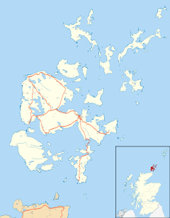 Kirkwall Location within Orkney | |
| Area | 3.63 km2 (1.40 sq mi) |
| Population | 9,293 (2011 Census)[2] |
| • Density | 2,560/km2 (6,600/sq mi) |
| OS grid reference | HY449109 |
| • Edinburgh | 210 mi (340 km) |
| • London | 528 mi (850 km) |
| Council area | |
| Lieutenancy area | |
| Country | Scotland |
| Sovereign state | United Kingdom |
| Post town | Kirkwall |
| Postcode district | KW15 |
| Dialling code | 01856 |
| Police | Scotland |
| Fire | Scottish |
| Ambulance | Scottish |
| UK Parliament | |
| Scottish Parliament |
|
The name Kirkwall comes from the Norse name Kirkjuvágr (Church Bay), which later changed to Kirkvoe, Kirkwaa and Kirkwall. Kirkwall was formerly the site of an ancient Norse town founded approximately 1000 years ago. Today, it is a transport hub with ferries to many locations.[3]
History
The town was first mentioned in Orkneyinga saga in the year 1046, when it was recorded as the residence of Rögnvald Brusason, the Earl of Orkney, who was killed by his uncle Thorfinn the Mighty. In 1486, King James III of Scotland elevated Kirkwall to the status of a royal burgh. On the western edge of the town, surrounded by Hatston Industrial Estate, there is a prehistoric monument, known as the "Grain Earth House" (see Historic Scotland). It is a short, low, stone-walled passage, deep underground, leading to a small pillared chamber. This kind of earth house (or "souterrain") is characteristic of the Northern Isles (although the Grain Earth House is unusually deep below ground). It was originally connected to a surface dwelling, which has since disappeared. The purpose of these Iron Age structures remains unknown. Further west, towards Grimbister, there is a similar structure, known as Rennibister Earth House.[4]
Governance
Kirkwall is the administrative centre of Orkney, and the site of the headquarters of both Orkney Islands Council and NHS Orkney.[5]
From 1708 to 1918, Kirkwall was a parliamentary burgh, and was combined with Dingwall, Dornoch, Tain and Wick to form the Northern Burghs constituency of the House of Commons of the Parliament of Great Britain (1708–1801) and then of the Parliament of the United Kingdom (1801–1918). (Cromarty was added to this constituency in 1832.) The constituency was a district of burghs known as the Tain Burghs until 1832, and then as the Wick Burghs. It was represented by one Member of Parliament (MP) until 1918, when the constituency was abolished and Kirkwall was merged politically into the county constituency of Orkney and Shetland. Although sometimes referred to as "The City and Royal Burgh of Kirkwall",[6] Kirkwall is not technically a city. (See city status in the United Kingdom.)[lower-alpha 1]
In the 1784–85 term, the well-known outspoken Liberal Charles James Fox represented Tain in the British Parliament. His political opponents fiercely objected to his having been elected from his usual constituency, Westminster; the unlikely resolution of this dispute was that Fox was made a burgess of Kirkwall.[8]
Geography
Kirkwall is 130 miles (210 kilometres) north of Aberdeen and 528 mi (850 km) north of London. It is situated on the northern coast of Mainland, Orkney, with its harbours in the bay of Kirkwall to the north, and with Scapa Flow 1.4 mi (2.3 km) to the south. Its parish, St Ola, forms the isthmus between Firth and Holm. It is the most populous island settlement in Scotland.[9]
Climate
Kirkwall has an oceanic climate (Cfb), with a strong maritime influence on its temperature. As a result, it is generally cooler than the rest of the UK in the summer (except that tends to be warmer than Shetland, being closer to mainland Scotland).[10]
| Climate data for Kirkwall, 26m asl, 1981–2010, Extremes 1951– | |||||||||||||
|---|---|---|---|---|---|---|---|---|---|---|---|---|---|
| Month | Jan | Feb | Mar | Apr | May | Jun | Jul | Aug | Sep | Oct | Nov | Dec | Year |
| Record high °C (°F) | 12.2 (54.0) |
12.8 (55.0) |
18.9 (66.0) |
18.3 (64.9) |
22.0 (71.6) |
22.8 (73.0) |
25.6 (78.1) |
24.8 (76.6) |
22.8 (73.0) |
19.4 (66.9) |
14.5 (58.1) |
12.8 (55.0) |
25.6 (78.1) |
| Average high °C (°F) | 6.4 (43.5) |
6.4 (43.5) |
7.6 (45.7) |
9.5 (49.1) |
12.0 (53.6) |
14.0 (57.2) |
15.9 (60.6) |
16.0 (60.8) |
14.1 (57.4) |
11.4 (52.5) |
8.6 (47.5) |
6.8 (44.2) |
10.7 (51.3) |
| Average low °C (°F) | 1.9 (35.4) |
1.7 (35.1) |
2.4 (36.3) |
3.8 (38.8) |
5.6 (42.1) |
8.1 (46.6) |
10.2 (50.4) |
10.3 (50.5) |
8.8 (47.8) |
6.7 (44.1) |
4.2 (39.6) |
2.3 (36.1) |
5.5 (41.9) |
| Record low °C (°F) | −7.8 (18.0) |
−7 (19) |
−6.8 (19.8) |
−4.9 (23.2) |
−2.1 (28.2) |
1.0 (33.8) |
0.0 (32.0) |
3.7 (38.7) |
0.5 (32.9) |
−1.6 (29.1) |
−5.5 (22.1) |
−7.6 (18.3) |
−7.8 (18.0) |
| Average rainfall mm (inches) | 109.7 (4.32) |
93.3 (3.67) |
95.7 (3.77) |
60.3 (2.37) |
48.0 (1.89) |
52.7 (2.07) |
57.4 (2.26) |
66.3 (2.61) |
95.3 (3.75) |
126.0 (4.96) |
126.0 (4.96) |
107.8 (4.24) |
1,038.5 (40.89) |
| Average rainy days (≥ 1.0 mm) | 20.1 | 16.8 | 17.9 | 13.4 | 10.6 | 10.7 | 11.6 | 12.5 | 16.2 | 19.6 | 20.8 | 18.5 | 188.7 |
| Mean monthly sunshine hours | 32.2 | 59.3 | 98.2 | 136.8 | 190.0 | 148.6 | 132.2 | 129.7 | 105.3 | 75.8 | 40.1 | 24.5 | 1,172.4 |
| Source 1: Met Office[11] | |||||||||||||
| Source 2: Royal Dutch Meteorological Institute/KMNI[12][13] | |||||||||||||
Demography
The population of Kirkwall is continuously on the rise. The population was predicted to be about 10,000 in 2018.[14][15]
Economy
Kirkwall harbour with nearly 1 kilometre (0.6 mi) of quay edge is the second commercial hub for Orkney after Hatston. There is a Marina, and support for fishing and dive vessels.[16] After extensive work on harbour facilities, the town has become a popular cruise ship stop, with several ships arriving each week in the season. This has added to the prosperity of the town and allowed a thriving sector of independently owned shops. Each year now, 140 cruise ships visit Kirkwall and Stromness.[17]
Weaving in Orkney took place from Viking times, with John Sclater & Co involved in Tweed production in Kirkwall in the 1970s. They used the brand names Norsaga and Jarltex.[18][19]
Culture and community
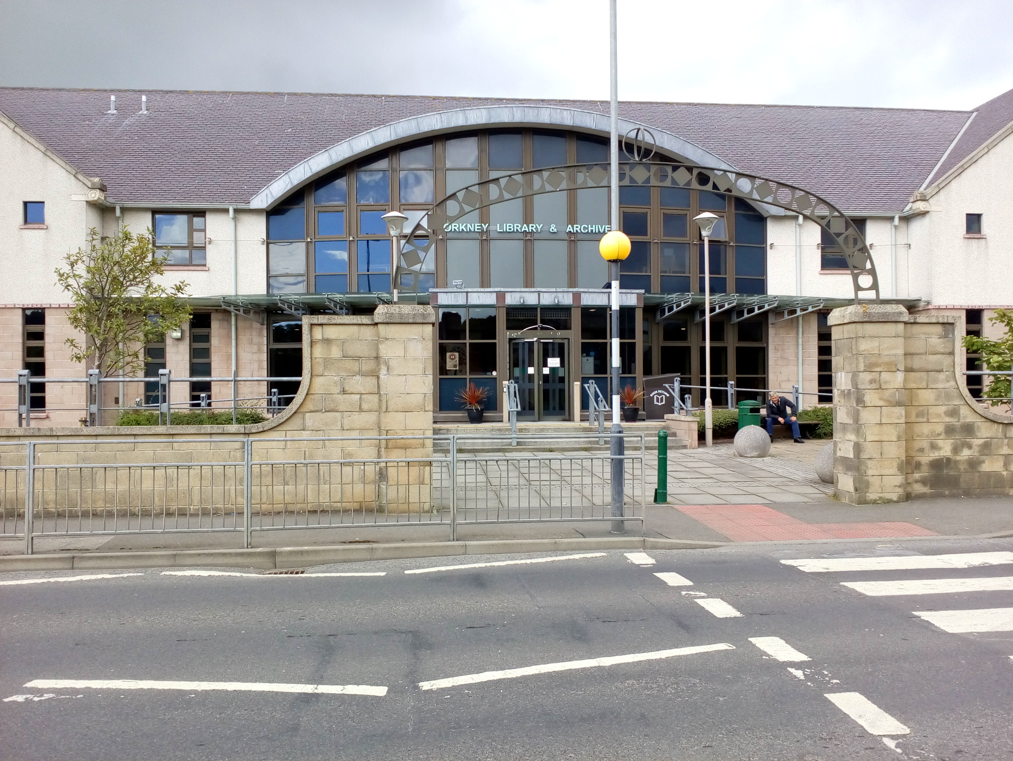
The Orkney Library and Archive is in Kirkwall. Kirkwall also has the most northerly of the world's Carnegie libraries, which was opened by Andrew Carnegie and his wife in 1909. The building survives, although the library has since moved to a larger building on Junction Road which opened in August 2003.[20]
The town has two museums, the larger being The Orkney Museum in Tankerness House, which contains items of local historical interest within one of Scotland's best-preserved 16th-century town-houses.[21] It is a Category A listed building Scotland. The prehistoric, Pictish and Viking collections are of international importance. The other museum is the Orkney Wireless Museum, dealing with the history of radio and recorded sound.[22]
There is a Royal National Lifeboat Institution lifeboat station.[23]
One of the major annual events in the town is the Ba Game, held each Christmas Day and New Year's Day between the Uppies and the Doonies, each team representing one half of the town.[24]
Media and the arts
The composer Peter Maxwell Davies was among a group which founded the annual St Magnus International Festival which is centred on Kirkwall each midsummer.[25]
Orkney Theatre, a 384-seat venue, was opened in 2014 next to Kirkwall Grammar School in The Meadows. It has an orchestra pit which can be made available for use by removing two rows of seats.[26]
Kirkwall Harbour can be seen in The Highlands and Islands – A Royal Tour, a 1973 documentary about Prince Charles' visit to the Highlands and Islands, directed by Oscar Marzaroli.[27] Scottish film-maker Margaret Tait was born in Kirkwall, and many of her films (in particular the Aspects of Kirkwall series) are set there.[28]
Long-running The Simpsons character Groundskeeper Willie was born in Kirkwall.[29]
Landmarks


Kirkwall has many 17th–18th-century houses and other structures in the local vernacular style. Kirkwall Town Hall was completed in 1884.[30]
Transport
Kirkwall is a port with ferry services to Aberdeen and Lerwick, as well as the principal north islands in the group. Hatson pier, the main ferry terminal, is some 2 mi (3 km) outside the town centre.[31]
The Aberdeen, Leith, Clyde & Tay Shipping Company operated steamer services to Kirkwall from 1836, with successor companies operating until 2002.[32]
Kirkwall Airport, the main airport for Orkney, is 2+1⁄2 mi (4 km) southeast of the town. There are no passenger rail services in Kirkwall, the nearby railways having been industrial or military.[33][34]
Education
Nursery schools
- Glaitness Nursery
- Papdale Nursery
- Peedie Breeks Nursery (closed 2020)
- Strynd Nursery
- Willow Tree Nursery
Primary schools
- Aurrida School
- Glaitness Primary School
- Papdale Primary School
Secondary schools
- Kirkwall Grammar School
Colleges and universities
- Orkney College UHI
- Institute of Northern Studies
The oldest school in Kirkwall, Kirkwall Grammar School, has been established since circa 1200.[35] The current school building was opened in 2014.[36]
The Orkney College main campus is situated in Kirkwall, in a purpose-built building that opened in 2000.[37]
Religious sites

The 'Kirk' of Kirkwall was not the Cathedral (which was originally at Birsay), but the 11th-century church of Saint Olaf of Norway. One late medieval doorway survives from this church, and an aumbry from the original church survives within the late 19th-century structure of the present-day Saint Olaf's Church (Episcopal) in the town's Dundas Crescent. At the heart of the town stands St Magnus Cathedral, which was founded in memory of Saint Magnus Erlendsson, Earl of Orkney 1108–1117 by Earl (later Saint) Rögnvald Kali.[38] Next to the Cathedral are the ruins of the former Bishop's Palace[39] and Earl's Palace.[40]
Sport
The Pickaquoy Centre, Orkney's largest leisure centre, is located in Kirkwall, which opened in 1999.[41]
Kirkwall Grammar School Sports Centre has indoor sports facilities, and grass and synthetic pitches, available to the public.[42]
Twin town – sister city
Kirkwall is twinned with:
Notable people
- Conran of Orkney, 7th-century Bishop of the Orkneys[44]
- Stanley Cursiter, Painter and Limner, was born in East Road[45]
- Ola Gorie, jewellery designer[46]
- Peter Marshall was educated in Kirkwall[47]
- Clara Anne Williams (née Rendall), born Kirkwall 24 July 1887,[48] missionary, teacher, and wife of Rev. Aeneas Francon Williams was awarded the Kaisar-i-Hind medal in 1946 for her work during WWII being in-charge of Red Cross work in Dooars, Bengal, India.[49]
- Groundskeeper Willie from The Simspons
Notes
References
- "Scotslanguage.com – Names in Scots – Places in Scotland". Archived from the original on 8 August 2017. Retrieved 19 August 2018.
- "Kirkwall profile" (PDF). Highlands and Islands Enterprise. May 2014. Archived from the original (PDF) on 27 October 2021.
- "A Guide to Scotland's Main Islands 22 July 2020". Archived from the original on 4 April 2021. Retrieved 28 February 2021.
- Historic Environment Scotland. "Rennibister, souterrain (SM90245)". Retrieved 22 February 2019.
- "About us". NHS Orkney. Retrieved 28 September 2022.
- Mackintosh, William R. (1887). Glimpses of Kirkwall and its people in the olden time. J. Anderson. p. 2.
- The Municipal Year Book 1972
- Mackintosh 1887, p. 318.
- "Kirkwall: the bustling capital of the Orkneys". British Heritage Travel. 19 August 2022. Retrieved 28 September 2022.
- M. C. Peel, B. L. Finlayson, T. A. Mcmahon (2007). "Updated world map of the Köppen-Geiger climate classification". Hydrology and Earth System Sciences Discussions, European Geosciences Union 4 (2). pp. 439–473. Archived from the original on 10 July 2019.
{{cite web}}: CS1 maint: multiple names: authors list (link) - "Kirkwall 1981–2010 averages". UKMO. Archived from the original on 7 October 2012. Retrieved 13 September 2012.
- "Kirkwall Extremes". KNMI. Archived from the original on 22 February 2013. Retrieved 3 November 2011.
- Valor, G. Ballester. "Synop report summary". www.ogimet.com. Archived from the original on 13 December 2019. Retrieved 1 July 2018.
- "Key Facts and Figures 2017-2018" (PDF). Orkney Islands Council. Archived from the original (PDF) on 14 August 2018. Retrieved 13 August 2018.[page needed]
- "Mid-2020 Population Estimates for Settlements and Localities in Scotland". National Records of Scotland. 31 March 2022. Retrieved 31 March 2022.
- "Kirkwall Port". Orkney Islands Council Harbour Authority. Archived from the original on 10 August 2018. Retrieved 9 August 2018.
- "Cruise Ships". Orkney Islands Council Harbour Authority. Archived from the original on 12 September 2017. Retrieved 12 September 2017.
- "Archived copy" (PDF). Scottish Industrial History. 4. 1981. Archived (PDF) from the original on 11 August 2018. Retrieved 10 August 2018.
{{cite journal}}: CS1 maint: archived copy as title (link)[page needed] - Henderson, Michelle (6 February 2018). "Orkney tweed? Harris had no production monopoly in the islands as academics find history of weaving the distinctive cloth in Orkney". Press and Journal. Archived from the original on 2 February 2020. Retrieved 2 February 2020.
- "Orkney Library and Archive". Orkney Islands Council. Retrieved 9 April 2022.
- "The Orkney Museum". Orkney Islands Council. Archived from the original on 7 August 2021. Retrieved 6 August 2021.
- "Orkney Wireless Museum". Orkney Wireless Museum. Retrieved 22 August 2009.
- "Kirkwall Lifeboat called out to fishing vessel – The Orcadian Online". 2 March 2017. Archived from the original on 4 August 2018. Retrieved 4 August 2018.
- Saslow, Eli (30 December 2007). "Tradition: The Old Ba' Game". The Washington Post. Archived from the original on 23 May 2011.
- "About". St Magnus International Festival, Orkney, Scotland. Archived from the original on 2 February 2020. Retrieved 2 February 2020.
- "HOME". Orkney Theatre. Archived from the original on 11 August 2018. Retrieved 10 August 2018.
- "Full record for 'Highlands and Islands – A Royal Tour'" Archived 25 July 2011 at the Wayback Machine Scottish Screen Archive. Retrieved 21 June 2010.
- "Margaret Tait (1918 - 1999)". Scottish Poetry Library. Retrieved 25 August 2018.
- "Groundskeeper Willie is from Orkney ... and he was 'torn apart' by Uppies and Doonies". 3 February 2012. Archived from the original on 21 January 2021. Retrieved 19 August 2020.
- Historic Environment Scotland. "Broad Street, Town Hall (LB45980)". Retrieved 28 September 2022.
- "Kirkwall (Hatston) Ferry Terminal – NorthLink Ferries". www.northlinkferries.co.uk. Archived from the original on 10 August 2018. Retrieved 9 August 2018.
- "P&O Scottish Ferries". Ships of the North. Retrieved 8 August 2009.
- "Trains to & from Orkney and Shetland – ScotRail". www.scotrail.co.uk. Archived from the original on 19 August 2018. Retrieved 19 August 2018.
- "ORCADIAN RAILWAYS". www.irsociety.co.uk. Archived from the original on 7 May 2019. Retrieved 19 August 2018.
- "About KGS". Kirkwall Grammar School. Archived from the original on 31 July 2018. Retrieved 30 July 2018.
- "Kirkwall Grammar School officially opened – The Orcadian Online". 17 June 2014. Archived from the original on 26 July 2018. Retrieved 25 July 2018.
- "The History of Kirkwall Grammar School" (PDF). p. 12. Retrieved 28 September 2022.
- Historic Environment Scotland. "Broad Street, St Magnus Cathedral (LB36668)". Retrieved 12 October 2021.
- Historic Environment Scotland. "Bishop's Palace, Kirkwall (SM90193)". Retrieved 22 February 2019.
- Historic Environment Scotland. "Earl's Palace, Kirkwall (SM90194)". Retrieved 22 February 2019.
- "Celebrating 20 years of the Pickaquoy Centre". The Orcadian. 17 April 2019. Retrieved 28 September 2022.
- "KGS Sports Centre". www.orkney.gov.uk. Archived from the original on 26 July 2018. Retrieved 25 July 2018.
- 'The Churchillian Paradigmand the "Other British Isles": An Examination of Second World WarRemembrance in Man, Orkney, and Jersey' Archived 4 November 2019 at the Wayback Machine, p.146
- Butler, Alban (1821), The lives of the fathers, martyrs, and other principal saints, vol. 2, London: John Murphy, p. 155, retrieved 19 August 2021
- "Biographical Index of Former Fellows of The Royal Society of Edinburgh, 1783–2002" (PDF). The Royal Society of Edinburgh. July 2006. Archived (PDF) from the original on 24 January 2013. Retrieved 19 August 2018.
- "Shopping directory: Jewellery: Scotland | Life and style". The Guardian. 8 December 2007. Retrieved 4 February 2016.
- "Professor Peter Marshall". Department of History. University of Warwick. Retrieved 15 November 2018.
- Clara Anne Rendall birth details:https://www.bayanne.info/Shetland/getperson.php?personID=I390219&tree=ID1 Archived 1 October 2021 at the Wayback Machine
- "Medical News". The Indian Medical Gazette. 80 (12): 629–632. December 1945. PMC 5218119. PMID 29015760.
External links
Authority control | |
|---|---|
| General | |
| National libraries | |
| Other |
|
На других языках
[de] Kirkwall
Kirkwall (inselschottisch: Kirkwaa; altnordisch: Kirkjuvágr) ist Hauptort der Insel Mainland, der größten der schottischen Orkneys, und hat 7045 Einwohner.[1] Die Stadt liegt auf einer Landenge zwischen Ost- und West-Mainland. Von hier führen Fährverbindungen zu den meisten Inseln der nördlichen Orkney sowie nach Aberdeen.- [en] Kirkwall
[ru] Керкуолл
Ке́ркуолл (англ. Kirkwall, скотс. Kirkwaa, гэльск. Baile na h-Eaglais) — самый крупный город на Оркнейских островах в Шотландии. Административный центр области Оркни. Население города составляет около 7 тыс. жителей. Расположен на востоке острова Мейнленд. Недалеко от города расположен одноимённый аэропорт.Другой контент может иметь иную лицензию. Перед использованием материалов сайта WikiSort.org внимательно изучите правила лицензирования конкретных элементов наполнения сайта.
WikiSort.org - проект по пересортировке и дополнению контента Википедии